Enable Location

We need your location to show you interesting places around you

Discover nearby places

Find interesting locations and hidden gems around you

Precise directions

Get accurate directions and distances to places

Your location is never shared with other users. It's only used when you tap the location button.

Henry Clay Furnace

Log in to your account

Start exploring — it's free

Trusted by 62,832 travelers worldwide

Continue with Google
Continue with Apple
or

We will send you a code to connect

By continuing, you accept our Terms and Conditions and our Privacy Policy

Check your inbox

We've sent a pincode in your inbox. Please enter the code below.

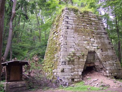
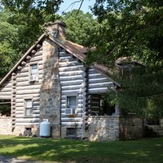
Henry Clay Furnace, 19th century iron furnace in Monongalia County, West Virginia, US.

Henry Clay Furnace is a stone structure in Cooper's Rock State Forest shaped like a truncated pyramid with a square footprint. The building demonstrates the engineering design typical of blast furnaces from this industrial era.

The furnace was built in the mid-1830s and was one of the first installations of its kind in the region. Its operational period ended in the 1840s, reflecting broader economic shifts of that time.

The site once served as the center of a small community that provided essential services to people living in the area during its working years. Today visitors can explore the remains of this settlement and understand how people existed together in this remote location.

The site is reachable via a marked hiking trail that includes steep sections and requires sturdy footwear. Visitors should be prepared for wooded terrain and check weather conditions before heading out.

The operation relied on a transportation network that moved materials from scattered mining sites across the surrounding hills. This logistical effort reveals how challenging it was to source raw materials in this remote mountain setting.

The community of curious travelers

AroundUs brings together thousands of curated places, local tips, and hidden gems, enriched daily by 60,000 contributors worldwide.

Start exploring
Location
GPS coordinates
39.64890,-79.81860
Latest update
December 12, 2025 17:44
Around this place
Mountaineer Field at Milan Puskar Stadium
United States of America

Mountaineer Field at Milan Puskar Stadium

11.7 km
Cheat Lake
United States of America

Cheat Lake

8.5 km
United States of America

Mountaineer Field

11.8 km
Mountainlair
United States of America

Mountainlair

11.7 km
Mont Chateau State Park
United States of America

Mont Chateau State Park

2.8 km
Boreman Hall
United States of America

Boreman Hall

11.6 km
Oglebay Hall
United States of America

Oglebay Hall

11.7 km
Stewart Hall
United States of America

Stewart Hall

11.8 km
Elizabeth Moore Hall
United States of America

Elizabeth Moore Hall

11.8 km
Elkins Coal and Coke Company Historic District
United States of America

Elkins Coal and Coke Company Historic District

11.6 km
Walters House
United States of America

Walters House

11.7 km
Point Marion Lock and Dam
United States of America

Point Marion Lock and Dam

11.8 km
Vance Farmhouse
United States of America

Vance Farmhouse

10.2 km
Purinton House
United States of America

Purinton House

11.8 km
South Park Historic District
United States of America

South Park Historic District

11.8 km
Kern's Fort
United States of America

Kern's Fort

11.5 km
Men's Hall
United States of America

Men's Hall

11.6 km
Harner Homestead
United States of America

Harner Homestead

9.2 km
Rogers House
United States of America

Rogers House

11.6 km
Greenmont Historic District
United States of America

Greenmont Historic District

11.6 km
Hackney House
United States of America

Hackney House

11.7 km
Cooper's Rock State Forest Superintendent's House and Garage
United States of America

Cooper's Rock State Forest Superintendent's House and Garage

3.4 km
Brown Building
United States of America

Brown Building

12 km
Women's Christian Temperance Union Community Building
United States of America

Women's Christian Temperance Union Community Building

12 km
Camp Rhododendron
United States of America

Camp Rhododendron

1.4 km
Ralphsnyder Decagonal Barn
United States of America

Ralphsnyder Decagonal Barn

11.7 km
Metropolitan Theatre
United States of America

Metropolitan Theatre

11.9 km
Second Ward Negro Elementary School
United States of America

Second Ward Negro Elementary School

11.6 km
Show the full map
« Henry Clay Furnace - 19th century iron furnace in Monongalia County, West Virginia, US » is provided by Around Us (aroundus.com). Images and texts are derived from Wikimedia project under a Creative Commons license. You are allowed to copy, distribute, and modify copies of this page, under the conditions set by the license, as long as this note is clearly visible.

Discover hidden gems everywhere you go!

From secret cafés to breathtaking viewpoints, skip the crowded tourist spots and find places that match your style. Our app makes it easy with voice search, smart filtering, route optimization, and insider tips from travelers worldwide. Download now for the complete mobile experience.

Around Us App Screenshot

A unique approach to discovering new places

Le Figaro

All the places worth exploring

France Info

A tailor-made excursion in just a few clicks

20 Minutes

Around Us
Travel Guide & Maps
Download

Send to your phone

QR Code
1

Open the camera app on your mobile.

2

Point at the QR code with your camera. A notification will appear.

3

Tap the notification to open the link.