Chest opened
+${chestReward.xp} XP
Explorer
NOUVEAU ×${chestReward.collectible.quantity}
tapez pour fermer
Chest locked

Open chests in the app

Around Us is built for your phone — chests unlock when you walk, explore and capture nearby places.

Enable Location

We need your location to show you interesting places around you

Discover nearby places

Find interesting locations and hidden gems around you

Precise directions

Get accurate directions and distances to places

Your location is never shared with other users. It's only used when you tap the location button.

Log in to your account

Start exploring — it's free

Trusted by 72,881 travelers worldwide

Continue with Google
Continue with Apple
or

We will send you a code to connect

By continuing, you accept our Terms and Conditions and our Privacy Policy

Check your inbox

We've sent a pincode in your inbox. Please enter the code below.

Illini State Park
Discussion Reviews Photo
2.3k Popularity

Illini State Park, State park along Illinois River in LaSalle County, US

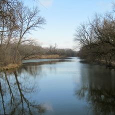
Illini State Park is a roughly 500-acre natural area with thick forests of hickory, ash, walnut, elm, cottonwood, oak, and maple trees along the Illinois River. Multiple picnic areas, shelters with fireplaces, playgrounds, and campsites with electrical hookups and sanitation facilities are spread throughout the grounds.

The park was officially dedicated in 1935 with buildings constructed by the Civilian Conservation Corps during the Great Depression. These structures built by that work program remain visible throughout the grounds today.

The name comes from the Native American tribes who lived on this land before European arrival. Today, the park preserves the connection between people and the river landscape they once knew.

The park sits right along the river with easy access and plenty of parking near the main areas. Trails and grounds vary in condition depending on the season and weather, so visitors should come prepared for muddy or uneven terrain.

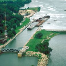
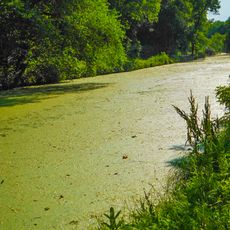
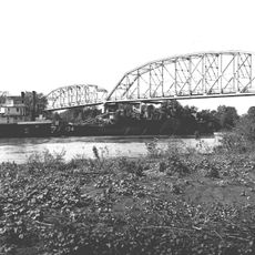
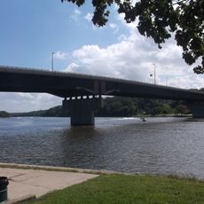
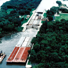
The grounds border a barge canal from the 1920s where large cargo vessels pass through the Marseilles Locks. Visitors can watch these big ships navigate through from various spots in the park.

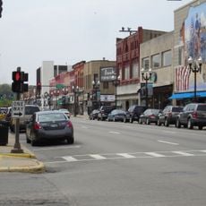
The community of curious travelers

AroundUs brings together thousands of curated places, local tips, and hidden gems, enriched daily by 60,000 contributors worldwide.

Start exploring
Location
Inception
1934
GPS coordinates
41.32170,-88.71580
Latest update
December 13, 2025 12:25
Around this place
Starved Rock State Park
United States of America

Starved Rock State Park

22.9 km
Matthiessen State Park
United States of America

Matthiessen State Park

26 km
Grand Village of the Illinois
United States of America

Grand Village of the Illinois

21.1 km
Abraham Lincoln Memorial Bridge
United States of America

Abraham Lincoln Memorial Bridge

30.2 km
Starved Rock Lock and Dam
United States of America

Starved Rock Lock and Dam

22.6 km
Washington Park Historic District
United States of America

Washington Park Historic District

11 km
John Hossack House
United States of America

John Hossack House

10.7 km
Gebhard Woods State Park
United States of America

Gebhard Woods State Park

23.8 km
Armour's Warehouse
United States of America

Armour's Warehouse

8.8 km
Marseilles Hydro Plant
United States of America

Marseilles Hydro Plant

538 m
Silas Williams House
United States of America

Silas Williams House

23.8 km
Ottawa Rail Bridge
United States of America

Ottawa Rail Bridge

11.2 km
Jeremiah Strawn House
United States of America

Jeremiah Strawn House

10.2 km
Andrew J. O'Conor III House
United States of America

Andrew J. O'Conor III House

9.9 km
Morris Bridge
United States of America

Morris Bridge

24.9 km
Hauge Lutheran Church
United States of America

Hauge Lutheran Church

16.5 km
Ruffin Drew Fletcher House
United States of America

Ruffin Drew Fletcher House

23.8 km
Veterans Memorial Bridge
United States of America

Veterans Memorial Bridge

10.7 km
Fisher-Nash-Griggs House
United States of America

Fisher-Nash-Griggs House

12.1 km
Ottawa East Side Historic District
United States of America

Ottawa East Side Historic District

10.1 km
Ransom Water Tower
United States of America

Ransom Water Tower

19.2 km
Streator Public Library
United States of America

Streator Public Library

24.6 km
Ottawa Commercial Historic District
United States of America

Ottawa Commercial Historic District

11 km
Morris Wide Water Canal Boat Site
United States of America

Morris Wide Water Canal Boat Site

26.6 km
Marseilles Lock and Dam Historic District
United States of America

Marseilles Lock and Dam Historic District

3.2 km
Ottawa Historical and Scouting Heritage Museum
United States of America

Ottawa Historical and Scouting Heritage Museum

11.3 km
Roxy Cinemas
United States of America

Roxy Cinemas

11 km
Majestic Theatre
United States of America

Majestic Theatre

24.3 km
Show the full map
Reviews
Share your experience

No review yet

Discussions
Start a discussion...

No discussion yet

« Illini State Park - State park along Illinois River in LaSalle County, US » is provided by Around Us (aroundus.com). Images and texts are derived from Wikimedia project under a Creative Commons license. You are allowed to copy, distribute, and modify copies of this page, under the conditions set by the license, as long as this note is clearly visible.

Discover hidden gems everywhere you go!

From secret cafés to breathtaking viewpoints, skip the crowded tourist spots and find places that match your style. Our app makes it easy with voice search, smart filtering, route optimization, and insider tips from travelers worldwide. Download now for the complete mobile experience.

Around Us App Screenshot

A unique approach to discovering new places

Le Figaro

All the places worth exploring

France Info

A tailor-made excursion in just a few clicks

20 Minutes

Around Us
Travel Guide & Maps
Download

Send to your phone

QR Code
1

Open the camera app on your mobile.

2

Point at the QR code with your camera. A notification will appear.

3

Tap the notification to open the link.