Enable Location

We need your location to show you interesting places around you

Discover nearby places

Find interesting locations and hidden gems around you

Precise directions

Get accurate directions and distances to places

Your location is never shared with other users. It's only used when you tap the location button.

Ida Street Viaduct

Log in to your account

Start exploring — it's free

Trusted by 61,867 travelers worldwide

Continue with Google
Continue with Apple
or

We will send you a code to connect

By continuing, you accept our Terms and Conditions and our Privacy Policy

Check your inbox

We've sent a pincode in your inbox. Please enter the code below.

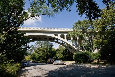
Ida Street Viaduct, Art Deco road bridge in Cincinnati, Ohio, United States

Ida Street Viaduct is a concrete bridge in Cincinnati featuring characteristic Art Deco geometric patterns on its surfaces. The structure spans across the Mount Adams area using reinforced construction techniques common to its era.

The bridge was built in 1931 to replace an earlier wooden streetcar line serving the area. It was added to the National Register of Historic Places in 1980 for its architectural value.

The structure carries a name rooted in local history and reflects the community's past. The Art Deco forms are visibly expressed through geometric details that show the era's taste for patterned surfaces.

The structure is passable for vehicles and remains in active use as a transportation route. Visitors can walk across or drive over it to view the architecture from different vantage points.

The structure retains its original concrete surfaces and Art Deco details largely unaltered since completion. This preservation lets visitors see firsthand the engineering approach and design preferences of the 1930s without modern modifications.

The community of curious travelers

AroundUs brings together thousands of curated places, local tips, and hidden gems, enriched daily by 60,000 contributors worldwide.

Start exploring
Location
Architectural style
Art Deco
GPS coordinates
39.10890,-84.49920
Latest update
December 14, 2025 15:02
Around this place
Miami and Erie Canal
United States of America

Miami and Erie Canal

919 m
Cincinnati Art Museum
United States of America

Cincinnati Art Museum

590 m
Hard Rock Casino Cincinnati
United States of America

Hard Rock Casino Cincinnati

646 m
Hard Rock Casino Cincinnati
United States of America

Hard Rock Casino Cincinnati

754 m
Taft Museum of Art
United States of America

Taft Museum of Art

797 m
Cincinnati Playhouse in the Park
United States of America

Cincinnati Playhouse in the Park

287 m
Krohn Conservatory
United States of America

Krohn Conservatory

1 km
Daniel Carter Beard Bridge
United States of America

Daniel Carter Beard Bridge

1 km
Spring House Gazebo
United States of America

Spring House Gazebo

777 m
Elsinore Arch
United States of America

Elsinore Arch

470 m
Cincinnati Times-Star Building
United States of America

Cincinnati Times-Star Building

792 m
St. Paul Church
United States of America

St. Paul Church

795 m
Hamilton County Courthouse
United States of America

Hamilton County Courthouse

980 m
Holy Cross Monastery and Chapel
United States of America

Holy Cross Monastery and Chapel

174 m
Statue of Abraham Lincoln
United States of America

Statue of Abraham Lincoln

967 m
Prospect Hill Historic District
United States of America

Prospect Hill Historic District

967 m
Alms and Doepke Dry Goods Company
United States of America

Alms and Doepke Dry Goods Company

961 m
Cincinnati Street Gas Lamps
United States of America

Cincinnati Street Gas Lamps

993 m
Krippendorf-Dittman Company
United States of America

Krippendorf-Dittman Company

986 m
George Hunt Pendleton House
United States of America

George Hunt Pendleton House

566 m
Pilgrim Presbyterian Church
United States of America

Pilgrim Presbyterian Church

125 m
Theodore Krumberg Building
United States of America

Theodore Krumberg Building

1.1 km
Sycamore-13th Street Grouping
United States of America

Sycamore-13th Street Grouping

913 m
Bernard Ratterman House
United States of America

Bernard Ratterman House

902 m
Nathaniel Ropes Building
United States of America

Nathaniel Ropes Building

1.1 km
Samuel Burdsal House
United States of America

Samuel Burdsal House

826 m
Lytle Park
United States of America

Lytle Park

962 m
Lytle Park Historic District
United States of America

Lytle Park Historic District

1 km
Show the full map
« Ida Street Viaduct - Art Deco road bridge in Cincinnati, Ohio, United States » is provided by Around Us (aroundus.com). Images and texts are derived from Wikimedia project under a Creative Commons license. You are allowed to copy, distribute, and modify copies of this page, under the conditions set by the license, as long as this note is clearly visible.

Discover hidden gems everywhere you go!

From secret cafés to breathtaking viewpoints, skip the crowded tourist spots and find places that match your style. Our app makes it easy with voice search, smart filtering, route optimization, and insider tips from travelers worldwide. Download now for the complete mobile experience.

Around Us App Screenshot

A unique approach to discovering new places

Le Figaro

All the places worth exploring

France Info

A tailor-made excursion in just a few clicks

20 Minutes

Around Us
Travel Guide & Maps
Download

Send to your phone

QR Code
1

Open the camera app on your mobile.

2

Point at the QR code with your camera. A notification will appear.

3

Tap the notification to open the link.