Enable Location

We need your location to show you interesting places around you

Discover nearby places

Find interesting locations and hidden gems around you

Precise directions

Get accurate directions and distances to places

Your location is never shared with other users. It's only used when you tap the location button.

Jayne's Hill

Log in to your account

Start exploring — it's free

Trusted by 61,564 travelers worldwide

Continue with Google
Continue with Apple
or

We will send you a code to connect

By continuing, you accept our Terms and Conditions and our Privacy Policy

Check your inbox

We've sent a pincode in your inbox. Please enter the code below.

Jayne's Hill

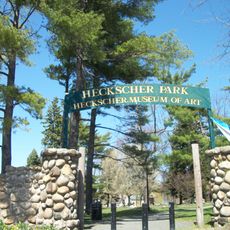
Jayne's Hill, Summit and mountain in West Hills County Park, Suffolk County, United States.

Description

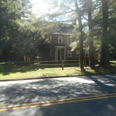
Jayne's Hill is a mountain summit in West Hills County Park on Long Island, reaching an elevation of approximately 400 feet (120 meters) above sea level. It stands as the highest natural point on the island, with established trails and a viewpoint where visitors can see across the surrounding landscape.

History

The hill was originally known as Oakley's High Hill Field, a name dating back to the early 19th century when it was first documented by local historians. Over time, the location became tied to efforts to protect it from development, shaping its role in the community's story.

Culture

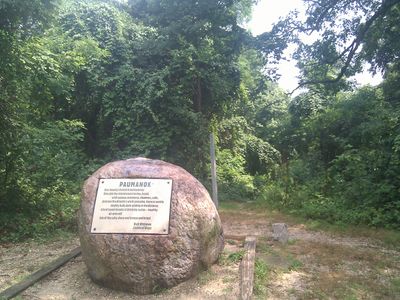
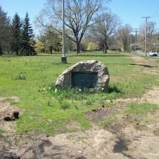
A stone marker at the summit displays a poem by Walt Whitman, honoring his ties to this location and the surrounding region. The marker draws visitors who come to read the verse and connect with the literary history embedded in the landscape.

Practical

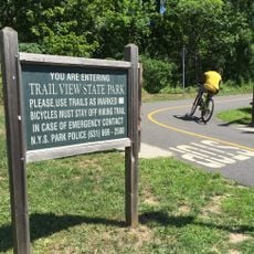
The summit is accessible via the Walt Whitman trail, a well-marked white-blazed path that leads through the park and is easy to follow. Parking is available nearby, making it convenient for visitors of varying hiking experience.

Did you know?

In the 1980s, activists and local residents rallied to stop construction of a radio tower on the summit, physically blocking equipment to protect the site. This overlooked chapter in the hill's story shows how the community has defended this place against unwanted development.

Location
GPS coordinates
40.81511,-73.42510
Latest update
December 7, 2025 19:24

AroundUs brings together thousands of curated places, local tips, and hidden gems, enriched daily by 60,000 contributors worldwide. Discover all places nearby (New York).

Around this place
Old Bethpage Village Restoration
United States of America

Old Bethpage Village Restoration

5.3 km
United States of America

Usdan Center for the Creative and Performing Arts

6.6 km
Walt Whitman Birthplace State Historic Site
United States of America

Walt Whitman Birthplace State Historic Site

1.1 km
Trail View State Park
United States of America

Trail View State Park

3.8 km
Heckscher Park
United States of America

Heckscher Park

6.7 km
Prime House
United States of America

Prime House

6.5 km
St. Abraam Coptic Orthodox Church
United States of America

St. Abraam Coptic Orthodox Church

3.2 km
Ezra Carll Homestead
United States of America

Ezra Carll Homestead

2.8 km
David Conklin House
United States of America

David Conklin House

5.6 km
Chichester's Inn
United States of America

Chichester's Inn

514 m
Old Town Hall Historic District
United States of America

Old Town Hall Historic District

6.3 km
Jacob Smith House
United States of America

Jacob Smith House

1.1 km
Henry Smith Farmstead
United States of America

Henry Smith Farmstead

5.5 km
Prime-Octagon House
United States of America

Prime-Octagon House

6.6 km
Charles Woodhull House
United States of America

Charles Woodhull House

6.6 km
Old Town Green Historic District
United States of America

Old Town Green Historic District

6.7 km
Eliphas Buffett House
United States of America

Eliphas Buffett House

3 km
Carll House
United States of America

Carll House

6.4 km
Rogers House
United States of America

Rogers House

5.7 km
West Neck Road Historic District
United States of America

West Neck Road Historic District

6.5 km
John Everit House
United States of America

John Everit House

2.5 km
Harbor Road Historic District
United States of America

Harbor Road Historic District

5.8 km
Dowden Tannery
United States of America

Dowden Tannery

3.3 km
Joseph Buffett House
United States of America

Joseph Buffett House

3 km
Museum of American Armor
United States of America

Museum of American Armor

4.8 km
The Great Jack O'Lantern Blaze: Long Island
United States of America

The Great Jack O'Lantern Blaze: Long Island

5.2 km
Heckscher Museum of Art
United States of America

Heckscher Museum of Art

6.7 km
Paramount
United States of America

Paramount

6.1 km
Show the full map
« Jayne's Hill - Summit and mountain in West Hills County Park, Suffolk County, United States » is provided by Around Us (aroundus.com). Images and texts are derived from Wikimedia project under a Creative Commons license. You are allowed to copy, distribute, and modify copies of this page, under the conditions set by the license, as long as this note is clearly visible.

Discover hidden gems everywhere you go!

From secret cafés to breathtaking viewpoints, skip the crowded tourist spots and find places that match your style. Our app makes it easy with voice search, smart filtering, route optimization, and insider tips from travelers worldwide. Download now for the complete mobile experience.

Around Us App Screenshot

A unique approach to discovering new places

Le Figaro

All the places worth exploring

France Info

A tailor-made excursion in just a few clicks

20 Minutes

Around Us
Travel Guide & Maps
Download

Send to your phone

QR Code
1

Open the camera app on your mobile.

2

Point at the QR code with your camera. A notification will appear.

3

Tap the notification to open the link.