Enable Location

We need your location to show you interesting places around you

Discover nearby places

Find interesting locations and hidden gems around you

Precise directions

Get accurate directions and distances to places

Your location is never shared with other users. It's only used when you tap the location button.

La Crosse West Channel Bridge

Log in to your account

Start exploring — it's free

Trusted by 62,410 travelers worldwide

Continue with Google
Continue with Apple
or

We will send you a code to connect

By continuing, you accept our Terms and Conditions and our Privacy Policy

Check your inbox

We've sent a pincode in your inbox. Please enter the code below.

La Crosse West Channel Bridge

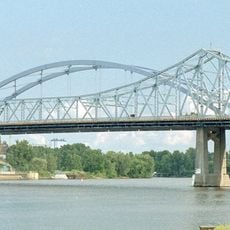
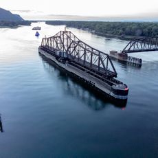
La Crosse West Channel Bridge, Road bridge connecting Barron Island in La Crosse County, United States

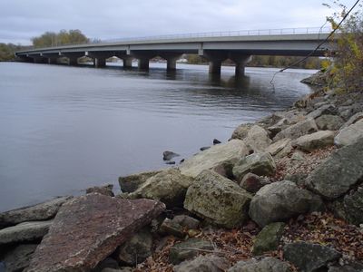
La Crosse West Channel Bridge is a four-lane road crossing that spans the Mississippi River connecting Wisconsin and Minnesota. The structure uses a steel plate girder design with truss elements supporting the main traffic deck.

Built in 1940 by engineering firms Klug and Smith Company and Minneapolis Bridge Company, the structure showcases mid-century bridge design. The original steel framework remains largely unchanged and continues to carry traffic daily.

The bridge links two communities separated by water, making daily travel between them possible and practical. It shapes how people from both sides interact and move through the region.

The bridge is open to traffic at all times and provides a straightforward crossing between the two states. During peak hours you may experience congestion, so allow extra time if you are crossing during busy periods.

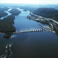
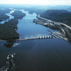
The bridge functions as part of an unusual transportation arrangement where a newer bridge was constructed alongside it rather than replacing it. This side-by-side existence of old and new infrastructure is something many travelers overlook when crossing.

The community of curious travelers

AroundUs brings together thousands of curated places, local tips, and hidden gems, enriched daily by 60,000 contributors worldwide.

Start exploring
Location
Location
GPS coordinates
43.81870,-91.27290
Latest update
December 14, 2025 18:11
Around this place
Shrine of Our Lady of Guadalupe
United States of America

Shrine of Our Lady of Guadalupe

10.5 km
Great River Bluffs State Park
United States of America

Great River Bluffs State Park

17.5 km
I-90 Mississippi River Bridge
United States of America

I-90 Mississippi River Bridge

4.8 km
Lock and Dam No. 7
United States of America

Lock and Dam No. 7

6 km
Mississippi River Bridge
United States of America

Mississippi River Bridge

1.5 km
St. Rose of Viterbo Convent
United States of America

St. Rose of Viterbo Convent

2.9 km
La Crosse Rail Bridge
United States of America

La Crosse Rail Bridge

1.9 km
Statue of Hiawatha
United States of America

Statue of Hiawatha

1.3 km
United States of America

Riverside Park

1.5 km
Hamlin Garland House
United States of America

Hamlin Garland House

17.8 km
Freight House
United States of America

Freight House

1.6 km
Mons Anderson House
United States of America

Mons Anderson House

2.1 km
Christ Episcopal Church
United States of America

Christ Episcopal Church

2.4 km
Gideon C. Hixon House
United States of America

Gideon C. Hixon House

2.1 km
Our Lady of Sorrows Chapel
United States of America

Our Lady of Sorrows Chapel

4.7 km
Church of the Holy Comforter
United States of America

Church of the Holy Comforter

13.8 km
La Crosse Commercial Historic District
United States of America

La Crosse Commercial Historic District

1.8 km
La Crosse Armory
United States of America

La Crosse Armory

3.9 km
Wittich Hall
United States of America

Wittich Hall

3.5 km
10th and Cass Streets Neighborhood Historic District
United States of America

10th and Cass Streets Neighborhood Historic District

2.6 km
La Crescent Public Library
United States of America

La Crescent Public Library

2.9 km
Gund Brewing Company Bottling Works
United States of America

Gund Brewing Company Bottling Works

3.7 km
Frank Eugene Nichols House
United States of America

Frank Eugene Nichols House

8.1 km
John L. Callahan House
United States of America

John L. Callahan House

2.9 km
23rd and 24th Streets Historic District
United States of America

23rd and 24th Streets Historic District

4.2 km
Rivoli Theatre
United States of America

Rivoli Theatre

1.9 km
LaCrosse State Teachers College Training School Building
United States of America

LaCrosse State Teachers College Training School Building

3.3 km
Lake Onalaska
United States of America

Lake Onalaska

6 km
Show the full map
« La Crosse West Channel Bridge - Road bridge connecting Barron Island in La Crosse County, United States » is provided by Around Us (aroundus.com). Images and texts are derived from Wikimedia project under a Creative Commons license. You are allowed to copy, distribute, and modify copies of this page, under the conditions set by the license, as long as this note is clearly visible.

Discover hidden gems everywhere you go!

From secret cafés to breathtaking viewpoints, skip the crowded tourist spots and find places that match your style. Our app makes it easy with voice search, smart filtering, route optimization, and insider tips from travelers worldwide. Download now for the complete mobile experience.

Around Us App Screenshot

A unique approach to discovering new places

Le Figaro

All the places worth exploring

France Info

A tailor-made excursion in just a few clicks

20 Minutes

Around Us
Travel Guide & Maps
Download

Send to your phone

QR Code
1

Open the camera app on your mobile.

2

Point at the QR code with your camera. A notification will appear.

3

Tap the notification to open the link.