·

Enable Location

We need your location to show you interesting places around you

Discover nearby places

Find interesting locations and hidden gems around you

Precise directions

Get accurate directions and distances to places

Your location is never shared with other users. It's only used when you tap the location button.

Lake Barkley

Log in to your account

Start exploring — it's free

Trusted by 62,751 travelers worldwide

Continue with Google
Continue with Apple
or

We will send you a code to connect

By continuing, you accept our Terms and Conditions and our Privacy Policy

Check your inbox

We've sent a pincode in your inbox. Please enter the code below.

Lake Barkley, Reservoir in Kentucky, United States.

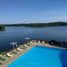
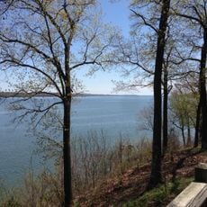
Lake Barkley is a reservoir in Kentucky that stretches across several counties and touches part of Tennessee, with roughly 1,000 miles of shoreline. The water extends from the dam in the north down to the Tennessee border in the south, offering coves, wooded banks, and shallow sections for boats and anglers.

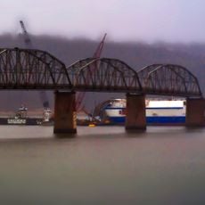
The Corps of Engineers built the dam in the early 1960s to control flooding and generate hydropower, with filling beginning in the mid-1960s. The reservoir bears the name of Alben Barkley, a Kentucky senator and vice president who championed such infrastructure projects.

The reservoir's creation erased several small towns and forced hundreds of families to move, with homes, churches, and cemeteries relocated before the flooding began. The old roads and foundations remain submerged, drawing divers who search for traces of the vanished communities.

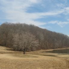
Water levels shift throughout the year depending on rainfall and management, with higher levels in spring than in fall. Anglers and boaters should check current conditions before heading out, as some coves become shallow when the water drops.

A narrow canal links the reservoir to neighboring Kentucky Lake, creating the longest artificial waterway of its kind in the eastern United States. Boats can traverse both bodies of water, using a system that extends far beyond the original river boundaries.

The community of curious travelers

AroundUs brings together thousands of curated places, local tips, and hidden gems, enriched daily by 60,000 contributors worldwide.

Start exploring
Location
Inception
January 1, 1966
GPS coordinates
37.02083,-88.22278
Latest update
December 22, 2025 14:06
Around this place
Land Between the Lakes National Recreation Area
United States of America

Land Between the Lakes National Recreation Area

22.5 km
Lake Barkley State Resort Park
United States of America

Lake Barkley State Resort Park

33.1 km
Kenlake State Resort Park
United States of America

Kenlake State Resort Park

29.8 km
Eggner's Ferry Bridge
United States of America

Eggner's Ferry Bridge

29.1 km
Cherokee State Park
United States of America

Cherokee State Park

30 km
United States of America

Lake Barkley Bridge

32.8 km
Old Eddyville Historic District
United States of America

Old Eddyville Historic District

13.4 km
Confederate Monument of Cadiz
United States of America

Confederate Monument of Cadiz

38.6 km
Cadiz Downtown Historic District
United States of America

Cadiz Downtown Historic District

38.6 km
Cadiz Main Street Residential District
United States of America

Cadiz Main Street Residential District

38.8 km
Cadiz Masonic Lodge No. 121 F. and A.M.
United States of America

Cadiz Masonic Lodge No. 121 F. and A.M.

38.5 km
United States of America

Mineral Mound State Park

13.8 km
United States of America

Cedar Bluff

42.8 km
United States of America

Pine Bluff

49 km
United States of America

Taylor Bluff

51.1 km
United States of America

Devils Pulpit

52.7 km
United States of America

Hillman Bluff

27.8 km
United States of America

Silver Cliffs

10.6 km
United States of America

Money Cliff

7.2 km
Brick Inn
United States of America

Brick Inn

33.3 km
United States of America

Mineral Mound State Park Golf Course

12.7 km
United States of America

Kerry Landing Clubhouse

15.7 km
United States of America

Hilltop Chimney

28.8 km
United States of America

Homeplace 1850s Working Farm at Land Between The Lakes

46.4 km
United States of America

Bison Range Overlook

47.2 km
United States of America

Scenic viewpoint

21.2 km
United States of America

Scenic viewpoint

9.4 km
United States of America

Cannon

21.4 km
Show the full map
« Lake Barkley - Reservoir in Kentucky, United States » is provided by Around Us (aroundus.com). Images and texts are derived from Wikimedia project under a Creative Commons license. You are allowed to copy, distribute, and modify copies of this page, under the conditions set by the license, as long as this note is clearly visible.

Discover hidden gems everywhere you go!

From secret cafés to breathtaking viewpoints, skip the crowded tourist spots and find places that match your style. Our app makes it easy with voice search, smart filtering, route optimization, and insider tips from travelers worldwide. Download now for the complete mobile experience.

Around Us App Screenshot

A unique approach to discovering new places

Le Figaro

All the places worth exploring

France Info

A tailor-made excursion in just a few clicks

20 Minutes

Around Us
Travel Guide & Maps
Download

Send to your phone

QR Code
1

Open the camera app on your mobile.

2

Point at the QR code with your camera. A notification will appear.

3

Tap the notification to open the link.