Enable Location

We need your location to show you interesting places around you

Discover nearby places

Find interesting locations and hidden gems around you

Precise directions

Get accurate directions and distances to places

Your location is never shared with other users. It's only used when you tap the location button.

Eggner's Ferry Bridge

Log in to your account

Start exploring — it's free

Trusted by travelers worldwide

Continue with Google
Continue with Apple
or

We will send you a code to connect

By continuing, you accept our Terms and Conditions and our Privacy Policy

Check your inbox

We've sent a pincode in your inbox. Please enter the code below.

Eggner's Ferry Bridge, Former Parker truss bridge in Marshall County and Trigg County, United States.

Description

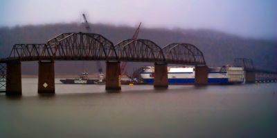
Eggner's Ferry Bridge was a steel structure stretching over 1020 meters across Kentucky Lake, featuring four Parker through truss spans supported by two Pratt truss end sections. The bridge provided two lanes of traffic and connected US Route 68 and Kentucky Route 80 across the water.

History

The structure opened in 1932 as a new crossing over Kentucky Lake, serving the region for nearly 84 years. Its design required modification in 1943 when the Kentucky Dam raised water levels, necessitating adjustment to the bridge's vertical clearance.

Culture

The bridge connected communities separated by Kentucky Lake, serving as a vital link that shaped how residents accessed jobs, schools, and recreation areas on opposite shores. People relied on this crossing as part of their everyday routines for decades.

Practical

The old bridge is no longer in use after being replaced in 2016, but remnants of the structure remain visible from the new bridge or from viewing areas along the lake shore. The site is accessible for viewing the historical crossing without needing to travel across it.

Did you know?

The structure endured for more than 80 years despite being exposed to harsh lake conditions and heavy traffic from two major routes. A cargo ship collision in 2012 caused significant damage to a large section, requiring emergency repairs that became one of the largest bridge restoration projects in the state.

Location
Location
Inception
1932
Official opening
March 25, 1932
Length
1,020.5 m
Longest Span
97.8 m
GPS coordinates
36.77218,-88.12046
Latest update
December 11, 2025 11:07

AroundUs brings together thousands of curated places, local tips, and hidden gems, enriched daily by 60,000 contributors worldwide. Discover all places nearby (Trigg County).

Around this place
Land Between the Lakes National Recreation Area
United States of America

Land Between the Lakes National Recreation Area

10.3 km
Kentucky Lake
United States of America

Kentucky Lake

29.9 km
Kentucky State Penitentiary
United States of America

Kentucky State Penitentiary

31 km
Lake Barkley
United States of America

Lake Barkley

29.1 km
Fort Donelson
United States of America

Fort Donelson

39 km
Kentucky Dam
United States of America

Kentucky Dam

29.9 km
CFSB Center
United States of America

CFSB Center

24.4 km
Lake Barkley State Resort Park
United States of America

Lake Barkley State Resort Park

19.4 km
Kenlake State Resort Park
United States of America

Kenlake State Resort Park

2.3 km
Confederate Monument in Murray
United States of America

Confederate Monument in Murray

24.2 km
Roy Stewart Stadium
United States of America

Roy Stewart Stadium

24.3 km
Kentucky Dam Village State Resort Park
United States of America

Kentucky Dam Village State Resort Park

30.3 km
Clarks River National Wildlife Refuge
United States of America

Clarks River National Wildlife Refuge

25.1 km
Cherokee State Park
United States of America

Cherokee State Park

2.1 km
First Baptist Church
United States of America

First Baptist Church

24.3 km
First Christian Church
United States of America

First Christian Church

24.2 km
Oak Hill
United States of America

Oak Hill

35.2 km
Old Eddyville Historic District
United States of America

Old Eddyville Historic District

30.9 km
Confederate Monument of Cadiz
United States of America

Confederate Monument of Cadiz

27.2 km
Cadiz Downtown Historic District
United States of America

Cadiz Downtown Historic District

27.2 km
Edwin S. Diuguid House
United States of America

Edwin S. Diuguid House

24.3 km
Thomas Lawson House
United States of America

Thomas Lawson House

27.8 km
Calloway County Courthouse
United States of America

Calloway County Courthouse

24.3 km
Cadiz Main Street Residential District
United States of America

Cadiz Main Street Residential District

27.6 km
Pete Lyles House
United States of America

Pete Lyles House

38.7 km
Cadiz Masonic Lodge No. 121 F. and A.M.
United States of America

Cadiz Masonic Lodge No. 121 F. and A.M.

27.1 km
L.B. Overby House
United States of America

L.B. Overby House

42.6 km
Lafayette Methodist Church
United States of America

Lafayette Methodist Church

43 km
Show the full map
« Eggner's Ferry Bridge - Former Parker truss bridge in Marshall County and Trigg County, United States » is provided by Around Us (aroundus.com). Images and texts are derived from Wikimedia project under a Creative Commons license. You are allowed to copy, distribute, and modify copies of this page, under the conditions set by the license, as long as this note is clearly visible.

Discover hidden gems everywhere you go!

From secret cafés to breathtaking viewpoints, skip the crowded tourist spots and find places that match your style. Our app makes it easy with voice search, smart filtering, route optimization, and insider tips from travelers worldwide. Download now for the complete mobile experience.

Around Us App Screenshot

A unique approach to discovering new places

Le Figaro

All the places worth exploring

France Info

A tailor-made excursion in just a few clicks

20 Minutes

Around Us
Travel Guide & Maps
Download

Send to your phone

QR Code
1

Open the camera app on your mobile.

2

Point at the QR code with your camera. A notification will appear.

3

Tap the notification to open the link.