Enable Location

We need your location to show you interesting places around you

Discover nearby places

Find interesting locations and hidden gems around you

Precise directions

Get accurate directions and distances to places

Your location is never shared with other users. It's only used when you tap the location button.

Fort Donelson

Log in to your account

Start exploring — it's free

Trusted by 63,015 travelers worldwide

Continue with Google
Continue with Apple
or

We will send you a code to connect

By continuing, you accept our Terms and Conditions and our Privacy Policy

Check your inbox

We've sent a pincode in your inbox. Please enter the code below.

Fort Donelson
Discussion Reviews 1 Photos
15.8k Popularity

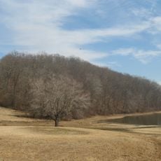
Fort Donelson, Civil War fort near Dover, Tennessee

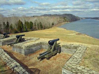
Fort Donelson is a former Confederate fortress on a hillside overlooking the Cumberland River, with earthwork walls, gun emplacements, and trenches laid out across the grounds. The site preserves the actual layout that commanders used to defend this crucial water passage.

The fortress was the site of one of the Confederacy's first major defeats in 1862 when General Grant captured it from Southern forces. This victory gave the Union control of a network of rivers that ran deep into enemy territory.

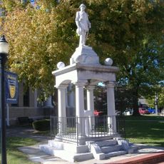
The cemetery here honors fallen soldiers from multiple wars, showing how this site remained important to the nation across generations. Visitors walking through the grounds sense the weight of sacrifice that extends far beyond a single conflict.

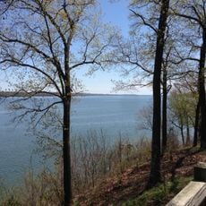
The cemetery and fortifications are spread across sloped terrain, so wear comfortable shoes and allow time to explore the various positions. A visitor center helps you understand the battlefield layout and what you are seeing as you walk the grounds.

During the February battle, temperatures dropped so severely that soldiers from both sides froze to death in their positions, making winter itself a deadly force. This deadly cold is often overlooked today but is documented through markers placed around the grounds.

The community of curious travelers

AroundUs brings together thousands of curated places, local tips, and hidden gems, enriched daily by 60,000 contributors worldwide.

Start exploring
Location
Inception
1862
GPS coordinates
36.49381,-87.85601
Latest update
December 7, 2025 19:29
Around this place
Land Between the Lakes National Recreation Area
United States of America

Land Between the Lakes National Recreation Area

44.9 km
CFSB Center
United States of America

CFSB Center

43.9 km
Lake Barkley State Resort Park
United States of America

Lake Barkley State Resort Park

39.5 km
Kenlake State Resort Park
United States of America

Kenlake State Resort Park

39.2 km
Confederate Monument in Murray
United States of America

Confederate Monument in Murray

42 km
Roy Stewart Stadium
United States of America

Roy Stewart Stadium

43.6 km
Eggner's Ferry Bridge
United States of America

Eggner's Ferry Bridge

39 km
Winfield Dunn Center
United States of America

Winfield Dunn Center

44.9 km
Cherokee State Park
United States of America

Cherokee State Park

38.9 km
Customs House Museum and Cultural Center
United States of America

Customs House Museum and Cultural Center

44.6 km
Mt. Zion Church and Cemetery
United States of America

Mt. Zion Church and Cemetery

21.5 km
First Baptist Church
United States of America

First Baptist Church

41.8 km
First Christian Church
United States of America

First Christian Church

42.1 km
Emerald Hill
United States of America

Emerald Hill

44.4 km
Confederate Monument of Cadiz
United States of America

Confederate Monument of Cadiz

41 km
Cadiz Downtown Historic District
United States of America

Cadiz Downtown Historic District

41 km
Quarry Limekiln
United States of America

Quarry Limekiln

23.5 km
Clarksville Methodist Church
United States of America

Clarksville Methodist Church

44.9 km
V.R. Harris House
United States of America

V.R. Harris House

24.1 km
First Presbyterian Church Manse
United States of America

First Presbyterian Church Manse

44.8 km
Edwin S. Diuguid House
United States of America

Edwin S. Diuguid House

42.1 km
Calloway County Courthouse
United States of America

Calloway County Courthouse

42 km
Forbes-Mabry House
United States of America

Forbes-Mabry House

44.6 km
Cadiz Main Street Residential District
United States of America

Cadiz Main Street Residential District

41.3 km
Alfred A. Robb House
United States of America

Alfred A. Robb House

44.7 km
Cadiz Masonic Lodge No. 121 F. and A.M.
United States of America

Cadiz Masonic Lodge No. 121 F. and A.M.

41.1 km
Northington-Beach House
United States of America

Northington-Beach House

45 km
Lafayette Methodist Church
United States of America

Lafayette Methodist Church

25.5 km
Show the full map
Reviews
Share your experience

No review yet

Discussions
Start a discussion...

No discussion yet

« Fort Donelson - Civil War fort near Dover, Tennessee » is provided by Around Us (aroundus.com). Images and texts are derived from Wikimedia project under a Creative Commons license. You are allowed to copy, distribute, and modify copies of this page, under the conditions set by the license, as long as this note is clearly visible.

Discover hidden gems everywhere you go!

From secret cafés to breathtaking viewpoints, skip the crowded tourist spots and find places that match your style. Our app makes it easy with voice search, smart filtering, route optimization, and insider tips from travelers worldwide. Download now for the complete mobile experience.

Around Us App Screenshot

A unique approach to discovering new places

Le Figaro

All the places worth exploring

France Info

A tailor-made excursion in just a few clicks

20 Minutes

Around Us
Travel Guide & Maps
Download

Send to your phone

QR Code
1

Open the camera app on your mobile.

2

Point at the QR code with your camera. A notification will appear.

3

Tap the notification to open the link.