Enable Location

We need your location to show you interesting places around you

Discover nearby places

Find interesting locations and hidden gems around you

Precise directions

Get accurate directions and distances to places

Your location is never shared with other users. It's only used when you tap the location button.

Clarks River National Wildlife Refuge

Log in to your account

Start exploring — it's free

Trusted by 61,951 travelers worldwide

Continue with Google
Continue with Apple
or

We will send you a code to connect

By continuing, you accept our Terms and Conditions and our Privacy Policy

Check your inbox

We've sent a pincode in your inbox. Please enter the code below.

Clarks River National Wildlife Refuge

Clarks River National Wildlife Refuge, National wildlife refuge in western Kentucky, United States.

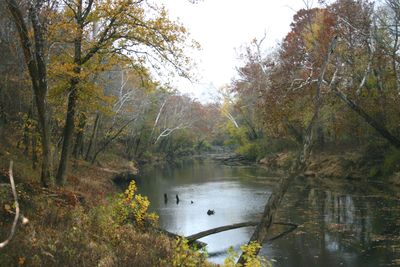
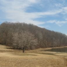
Clarks River National Wildlife Refuge is a protected area in western Kentucky featuring bottomland hardwood forests, wetlands, and open fields along the Clarks River. The landscape contains diverse habitats and zones that support numerous animal species throughout the year.

The refuge was established in 1997 following extensive environmental evaluations and became the 549th National Wildlife Refuge in the United States. Its creation resulted from efforts to protect the river ecosystem and wildlife habitats over the long term.

The refuge takes its name from William Clark of the Lewis and Clark Expedition or his brother George Rogers Clark, connecting the site to early American exploration. Locals see this place as part of the region's identity and natural heritage.

Multiple trails with interpretive signs lead through the area for wildlife watching, photography, hunting, and fishing activities. Visitors should come prepared for the season and check local guidelines for the specific activities they want to enjoy.

The refuge maintains six managed waterfowl areas totaling over 200 acres that provide vital resting stops for migratory birds along the Mississippi Flyway. These carefully maintained wetlands support thousands of birds during their seasonal journeys.

The community of curious travelers

AroundUs brings together thousands of curated places, local tips, and hidden gems, enriched daily by 60,000 contributors worldwide.

Start exploring
Location
Inception
1997
GPS coordinates
36.88900,-88.36120
Latest update
December 13, 2025 12:22
Around this place
Land Between the Lakes National Recreation Area
United States of America

Land Between the Lakes National Recreation Area

25.8 km
Kentucky Lake
United States of America

Kentucky Lake

16 km
Lake Barkley
United States of America

Lake Barkley

19.2 km
Kincaid Mounds State Historic Site
United States of America

Kincaid Mounds State Historic Site

24.3 km
Kentucky Dam
United States of America

Kentucky Dam

16.1 km
CFSB Center
United States of America

CFSB Center

29.9 km
Kenlake State Resort Park
United States of America

Kenlake State Resort Park

24.1 km
Roy Stewart Stadium
United States of America

Roy Stewart Stadium

30.1 km
Eggner's Ferry Bridge
United States of America

Eggner's Ferry Bridge

25.1 km
Kentucky Dam Village State Resort Park
United States of America

Kentucky Dam Village State Resort Park

14.3 km
Wooldridge Monuments
United States of America

Wooldridge Monuments

29 km
Fort Anderson
United States of America

Fort Anderson

31.2 km
Lloyd Tilghman House
United States of America

Lloyd Tilghman House

30.5 km
Cherokee State Park
United States of America

Cherokee State Park

24.5 km
Lloyd Tilghman Memorial
United States of America

Lloyd Tilghman Memorial

31.4 km
David Yeiser House
United States of America

David Yeiser House

30.9 km
Confederate Memorial in Mayfield
United States of America

Confederate Memorial in Mayfield

29.4 km
Confederate Memorial Gates in Mayfield
United States of America

Confederate Memorial Gates in Mayfield

29 km
Mayfield Downtown Commercial District
United States of America

Mayfield Downtown Commercial District

29.5 km
First Christian Church
United States of America

First Christian Church

31.3 km
Oak Hill
United States of America

Oak Hill

15.8 km
Old Eddyville Historic District
United States of America

Old Eddyville Historic District

30.9 km
Masonic Temple
United States of America

Masonic Temple

30.1 km
Edwin S. Diuguid House
United States of America

Edwin S. Diuguid House

31.4 km
Thomas Lawson House
United States of America

Thomas Lawson House

16.9 km
Richard Olive House
United States of America

Richard Olive House

28.1 km
Pete Lyles House
United States of America

Pete Lyles House

14.1 km
Masonic Hall-Federal Commissary Building
United States of America

Masonic Hall-Federal Commissary Building

28.3 km
Show the full map
« Clarks River National Wildlife Refuge - National wildlife refuge in western Kentucky, United States » is provided by Around Us (aroundus.com). Images and texts are derived from Wikimedia project under a Creative Commons license. You are allowed to copy, distribute, and modify copies of this page, under the conditions set by the license, as long as this note is clearly visible.

Discover hidden gems everywhere you go!

From secret cafés to breathtaking viewpoints, skip the crowded tourist spots and find places that match your style. Our app makes it easy with voice search, smart filtering, route optimization, and insider tips from travelers worldwide. Download now for the complete mobile experience.

Around Us App Screenshot

A unique approach to discovering new places

Le Figaro

All the places worth exploring

France Info

A tailor-made excursion in just a few clicks

20 Minutes

Around Us
Travel Guide & Maps
Download

Send to your phone

QR Code
1

Open the camera app on your mobile.

2

Point at the QR code with your camera. A notification will appear.

3

Tap the notification to open the link.