Enable Location

We need your location to show you interesting places around you

Discover nearby places

Find interesting locations and hidden gems around you

Precise directions

Get accurate directions and distances to places

Your location is never shared with other users. It's only used when you tap the location button.

Kincaid Mounds State Historic Site

Log in to your account

Start exploring — it's free

Trusted by 62,170 travelers worldwide

Continue with Google
Continue with Apple
or

We will send you a code to connect

By continuing, you accept our Terms and Conditions and our Privacy Policy

Check your inbox

We've sent a pincode in your inbox. Please enter the code below.

Kincaid Mounds State Historic Site, Archaeological complex with platform mounds in Massac and Pope Counties, United States.

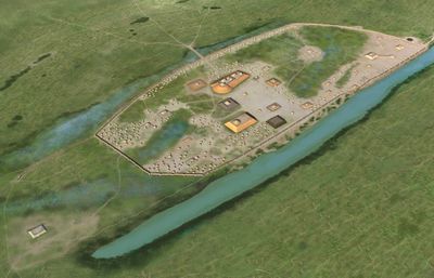
Kincaid Mounds State Historic Site contains eleven platform mounds and eight other earthworks that stretch along the Ohio River across 105 acres (42 hectares). The site features a central courtyard ringed by raised structures, with the tallest mound positioned at the southwest corner.

The settlement arose around 1050 and remained active until roughly 1400, during the height of Mississippian society in the middle river valley. Excavations by the University of Chicago from 1934 to 1944 revealed how the community was organized and how residents went about their daily routines.

The central plaza served as a gathering space where Native Americans conducted ceremonies, celebrated harvests, and maintained social hierarchies through organized activities.

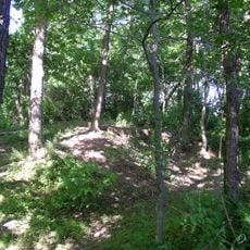
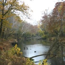
Visitors reach an observation platform on Kincaid Mounds Road, where signs explain each structure and the role it played in the community. Walking paths across the site are unpaved, so sturdy footwear helps when the ground becomes soft after rain.

During excavation work, researchers developed new methods for dating pottery fragments that later became standard at other sites across the region. The digging also helped clarify how maize cultivation and food storage practices evolved in the middle Ohio Valley.

The community of curious travelers

AroundUs brings together thousands of curated places, local tips, and hidden gems, enriched daily by 60,000 contributors worldwide.

Start exploring
Location
Location
GPS coordinates
37.08056,-88.49167
Latest update
December 6, 2025 11:00
Around this place
Kentucky Lake
United States of America

Kentucky Lake

21.1 km
Lake Barkley
United States of America

Lake Barkley

24.8 km
Kentucky Dam
United States of America

Kentucky Dam

21.1 km
Fort Massac
United States of America

Fort Massac

18.7 km
Irvin S. Cobb Bridge
United States of America

Irvin S. Cobb Bridge

12.8 km
Metropolis Bridge
United States of America

Metropolis Bridge

23.3 km
United States of America

Honeywell Uranium Hexafluoride Processing Facility

25.6 km
Whitehaven
United States of America

Whitehaven

14.7 km
Kentucky Dam Village State Resort Park
United States of America

Kentucky Dam Village State Resort Park

19.3 km
Lock and Dam Number 52
United States of America

Lock and Dam Number 52

15.3 km
Smithland Lock and Dam
United States of America

Smithland Lock and Dam

11.1 km
Rowlandton Mound Site
United States of America

Rowlandton Mound Site

13 km
Clarks River National Wildlife Refuge
United States of America

Clarks River National Wildlife Refuge

24.3 km
Fort Anderson
United States of America

Fort Anderson

9.9 km
Lloyd Tilghman House
United States of America

Lloyd Tilghman House

9.7 km
Lloyd Tilghman Memorial
United States of America

Lloyd Tilghman Memorial

11.3 km
David Yeiser House
United States of America

David Yeiser House

9.9 km
Confederate Monument in Paducah
United States of America

Confederate Monument in Paducah

11.7 km
Elijah P. Curtis House
United States of America

Elijah P. Curtis House

22.9 km
Oak Hill
United States of America

Oak Hill

13.9 km
Masonic Temple
United States of America

Masonic Temple

9.6 km
Thomas Lawson House
United States of America

Thomas Lawson House

24.2 km
Kenmil Place
United States of America

Kenmil Place

14.2 km
Richard Olive House
United States of America

Richard Olive House

10.2 km
Pete Lyles House
United States of America

Pete Lyles House

18.1 km
Masonic Hall-Federal Commissary Building
United States of America

Masonic Hall-Federal Commissary Building

10.1 km
Massac Theatre
United States of America

Massac Theatre

22.8 km
Fort Massac State Park
United States of America

Fort Massac State Park

18.7 km
Show the full map
« Kincaid Mounds State Historic Site - Archaeological complex with platform mounds in Massac and Pope Counties, United States » is provided by Around Us (aroundus.com). Images and texts are derived from Wikimedia project under a Creative Commons license. You are allowed to copy, distribute, and modify copies of this page, under the conditions set by the license, as long as this note is clearly visible.

Discover hidden gems everywhere you go!

From secret cafés to breathtaking viewpoints, skip the crowded tourist spots and find places that match your style. Our app makes it easy with voice search, smart filtering, route optimization, and insider tips from travelers worldwide. Download now for the complete mobile experience.

Around Us App Screenshot

A unique approach to discovering new places

Le Figaro

All the places worth exploring

France Info

A tailor-made excursion in just a few clicks

20 Minutes

Around Us
Travel Guide & Maps
Download

Send to your phone

QR Code
1

Open the camera app on your mobile.

2

Point at the QR code with your camera. A notification will appear.

3

Tap the notification to open the link.