Enable Location

We need your location to show you interesting places around you

Discover nearby places

Find interesting locations and hidden gems around you

Precise directions

Get accurate directions and distances to places

Your location is never shared with other users. It's only used when you tap the location button.

Lock and Dam Number 52

Log in to your account

Start exploring — it's free

Trusted by 65,821 travelers worldwide

Continue with Google
Continue with Apple
or

We will send you a code to connect

By continuing, you accept our Terms and Conditions and our Privacy Policy

Check your inbox

We've sent a pincode in your inbox. Please enter the code below.

Lock and Dam Number 52
Discussion Reviews 1 Photos
3.4k Popularity

Lock and Dam Number 52, Navigation complex on Ohio River, United States

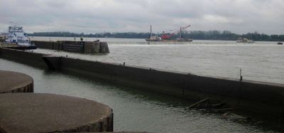
Lock and Dam Number 52 was a navigation complex on the Ohio River, located near Olmsted, Illinois, close to the Kentucky border. It had two separate locks of different widths to accommodate the range of commercial vessels using the river.

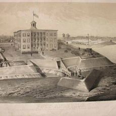
The U.S. Army Corps of Engineers built the complex in 1929 as part of a broader effort to make the Ohio River reliably navigable for commercial traffic. After nearly a century of use, it was torn down between 2019 and 2020 once a replacement facility had come into service.

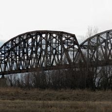
The Ohio River has long been a working river, and communities along its banks grew around the movement of coal, grain, and other goods by barge. A facility like this one was part of the daily rhythm of river towns that depended on steady water traffic.

Since the complex has been demolished, there are no standing structures to see at the site today. Visitors interested in the history of river navigation in the area can still view the Ohio River from the surrounding banks to get a sense of the waterway's scale and importance.

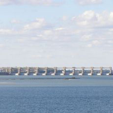
The replacement facility, Olmsted Lock and Dam, took over 25 years to complete, making it one of the longest infrastructure projects in the history of the U.S. Army Corps of Engineers. During that entire period, Lock and Dam Number 52 continued to operate and handle river freight without interruption.

The community of curious travelers

AroundUs brings together thousands of curated places, local tips, and hidden gems, enriched daily by 60,000 contributors worldwide.

Start exploring
GPS coordinates
37.12210,-88.65600
Latest update
March 3, 2026 13:59
Around this place
Kincaid Mounds State Historic Site
United States of America

Kincaid Mounds State Historic Site

15.3 km
Fort Massac
United States of America

Fort Massac

3.7 km
Irvin S. Cobb Bridge
United States of America

Irvin S. Cobb Bridge

2.5 km
Metropolis Bridge
United States of America

Metropolis Bridge

8 km
United States of America

Honeywell Uranium Hexafluoride Processing Facility

10.5 km
Whitehaven
United States of America

Whitehaven

7.9 km
Dixon Springs State Park
United States of America

Dixon Springs State Park

29 km
Smithland Lock and Dam
United States of America

Smithland Lock and Dam

20.8 km
Mermet Lake State Fish and Wildlife Area
United States of America

Mermet Lake State Fish and Wildlife Area

23.3 km
Rowlandton Mound Site
United States of America

Rowlandton Mound Site

3.5 km
Fort Anderson
United States of America

Fort Anderson

5.8 km
Lloyd Tilghman House
United States of America

Lloyd Tilghman House

6.4 km
Lloyd Tilghman Memorial
United States of America

Lloyd Tilghman Memorial

5.5 km
Mantle Rock Archeological District
United States of America

Mantle Rock Archeological District

32.7 km
David Yeiser House
United States of America

David Yeiser House

6 km
Confederate Monument in Paducah
United States of America

Confederate Monument in Paducah

4.9 km
Elijah P. Curtis House
United States of America

Elijah P. Curtis House

7.6 km
Golconda Historic District
United States of America

Golconda Historic District

31.1 km
United States of America

Lusk's Ferry, Illinois

31.3 km
Oak Hill
United States of America

Oak Hill

29.2 km
Masonic Temple
United States of America

Masonic Temple

6.8 km
Kenmil Place
United States of America

Kenmil Place

7.1 km
Richard Olive House
United States of America

Richard Olive House

22.5 km
Pete Lyles House
United States of America

Pete Lyles House

25.9 km
Masonic Hall-Federal Commissary Building
United States of America

Masonic Hall-Federal Commissary Building

22.2 km
Massac Theatre
United States of America

Massac Theatre

7.5 km
Fort Massac State Park
United States of America

Fort Massac State Park

3.7 km
Superman statue
United States of America

Superman statue

7.6 km
Show the full map
Reviews
Share your experience

No review yet

Discussions
Start a discussion...

No discussion yet

« Lock and Dam Number 52 - Navigation complex on Ohio River, United States » is provided by Around Us (aroundus.com). Images and texts are derived from Wikimedia project under a Creative Commons license. You are allowed to copy, distribute, and modify copies of this page, under the conditions set by the license, as long as this note is clearly visible.

Discover hidden gems everywhere you go!

From secret cafés to breathtaking viewpoints, skip the crowded tourist spots and find places that match your style. Our app makes it easy with voice search, smart filtering, route optimization, and insider tips from travelers worldwide. Download now for the complete mobile experience.

Around Us App Screenshot

A unique approach to discovering new places

Le Figaro

All the places worth exploring

France Info

A tailor-made excursion in just a few clicks

20 Minutes

Around Us
Travel Guide & Maps
Download

Send to your phone

QR Code
1

Open the camera app on your mobile.

2

Point at the QR code with your camera. A notification will appear.

3

Tap the notification to open the link.