Smithland Lock and Dam

Log in to your account

AroundUs is a community-driven map of interesting places, built by curious explorers like you. It grows with every review, story, and photo you share.
Connect to save your favorite spots, contribute locations, and create personalized routes.
Continue with Google
Continue with Apple
Continue with X
Continue with Facebook
Continue with email
By continuing, you accept our Terms and Conditions and our Privacy Policy
Create an account

Smithland Lock and Dam

Add to collection
Map
Suggest a change
Share

Smithland Lock and Dam, Navigation infrastructure on the Ohio River at Brookport, United States.

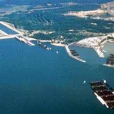
Smithland Lock and Dam is a navigation facility that spans across the Ohio River where Kentucky and Illinois meet. It includes two locks that allow barges to pass through while maintaining consistent water levels downstream.

The facility was built between 1971 and 1980, replacing two older lock systems that previously served this stretch of the Ohio River. This newer construction improved river traffic by offering more efficient operations and greater capacity.

The Louisville District of the United States Army Corps of Engineers maintains this structure as part of the Ohio River navigation system.

The site offers viewpoints from nearby roads where you can watch barges pass through the locks. Visit during shipping season to see the facility in active operation with regular barge traffic.

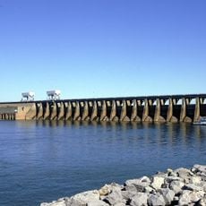
The facility operates using eleven specialized Tainter gates that control water flow and river levels. These gates are the key mechanism behind the dam's ability to manage the Ohio River's dynamics.

GPS coordinates: 37.16640,-88.42840

Latest update: December 12, 2025 17:45

Photos
Around this place
Kentucky Lake
United States of America

Kentucky Lake

22.2 km
Lake Barkley
United States of America

Lake Barkley

24.4 km
Kincaid Mounds State Historic Site
United States of America

Kincaid Mounds State Historic Site

11.1 km
Kentucky Dam
United States of America

Kentucky Dam

22.2 km
Fort Massac
United States of America

Fort Massac

23.1 km
Irvin S. Cobb Bridge
United States of America

Irvin S. Cobb Bridge

18.7 km
Whitehaven
United States of America

Whitehaven

23.7 km
Kentucky Dam Village State Resort Park
United States of America

Kentucky Dam Village State Resort Park

21.4 km
Lock and Dam Number 52
United States of America

Lock and Dam Number 52

20.8 km
Rowlandton Mound Site
United States of America

Rowlandton Mound Site

20.1 km
Fort Anderson
United States of America

Fort Anderson

17.4 km
Lloyd Tilghman House
United States of America

Lloyd Tilghman House

17.8 km
Lloyd Tilghman Memorial
United States of America

Lloyd Tilghman Memorial

19.4 km
Mantle Rock Archeological District
United States of America

Mantle Rock Archeological District

20.7 km
David Yeiser House
United States of America

David Yeiser House

17.7 km
Confederate Monument in Paducah
United States of America

Confederate Monument in Paducah

19.5 km
Elijah P. Curtis House
United States of America

Elijah P. Curtis House

27.2 km
Golconda Historic District
United States of America

Golconda Historic District

22.9 km
United States of America

Lusk's Ferry, Illinois

22.8 km
Oak Hill
United States of America

Oak Hill

16.7 km
Masonic Temple
United States of America

Masonic Temple

17.9 km
Thomas Lawson House
United States of America

Thomas Lawson House

24.9 km
Kenmil Place
United States of America

Kenmil Place

23 km
Richard Olive House
United States of America

Richard Olive House

3.7 km
Masonic Hall-Federal Commissary Building
United States of America

Masonic Hall-Federal Commissary Building

3.5 km
Massac Theatre
United States of America

Massac Theatre

27 km
Fort Massac State Park
United States of America

Fort Massac State Park

23.1 km
Superman statue
United States of America

Superman statue

27 km
Show the full map
Reviews

Visited this place? Tap the stars to rate it and share your experience / photos with the community! Try now! You can cancel it anytime.

« Smithland Lock and Dam - Navigation infrastructure on the Ohio River at Brookport, United States » is provided by Around Us (aroundus.com). Images and texts are derived from Wikimedia project under a Creative Commons license. You are allowed to copy, distribute, and modify copies of this page, under the conditions set by the license, as long as this note is clearly visible.

Discover hidden gems everywhere you go!

From secret cafés to breathtaking viewpoints, skip the crowded tourist spots and find places that match your style. Our app makes it easy with voice search, smart filtering, route optimization, and insider tips from travelers worldwide. Download now for the complete mobile experience.

Around Us App Screenshot

A unique approach to discovering new places

Le Figaro

All the places worth exploring

France Info

A tailor-made excursion in just a few clicks

20 Minutes