·

Enable Location

We need your location to show you interesting places around you

Discover nearby places

Find interesting locations and hidden gems around you

Precise directions

Get accurate directions and distances to places

Your location is never shared with other users. It's only used when you tap the location button.

Kentucky Dam

Log in to your account

Start exploring — it's free

Trusted by 62,754 travelers worldwide

Continue with Google
Continue with Apple
or

We will send you a code to connect

By continuing, you accept our Terms and Conditions and our Privacy Policy

Check your inbox

We've sent a pincode in your inbox. Please enter the code below.

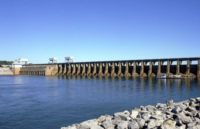
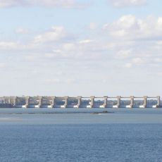
Kentucky Dam, Hydroelectric power station and dam at Tennessee River, Kentucky.

Kentucky Dam is a 2,567-meter-long structure spanning the Tennessee River between Livingston and Marshall counties. Two navigation locks allow commercial vessels to pass through while the facility generates electricity from the water flow.

Construction started in 1938 by the Tennessee Valley Authority and was completed in 1944 during World War II. The project was part of a broader effort to develop and manage river resources across the region.

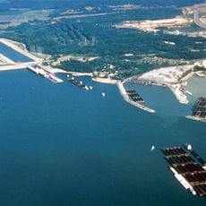
The dam transformed how local communities relate to water, creating Kentucky Lake and opening new possibilities for fishing, boating, and outdoor recreation. People gather here regularly for these water-based activities.

Visitors can view the structure from above and watch ships passing through the navigation locks on the river. A nearby visitor center provides information about how the facility operates and its role in the area.

The structure was specially engineered to withstand earthquakes because it sits near the New Madrid Seismic Zone. This made construction more challenging than typical dam projects in other regions.

The community of curious travelers

AroundUs brings together thousands of curated places, local tips, and hidden gems, enriched daily by 60,000 contributors worldwide.

Start exploring
Location
Inception
1938
Length
2,567 m
GPS coordinates
37.01310,-88.26920
Latest update
December 7, 2025 20:20
Around this place
Land Between the Lakes National Recreation Area
United States of America

Land Between the Lakes National Recreation Area

24.5 km
Kentucky Lake
United States of America

Kentucky Lake

95 m
Lake Barkley
United States of America

Lake Barkley

4.2 km
Kincaid Mounds State Historic Site
United States of America

Kincaid Mounds State Historic Site

21.1 km
Irvin S. Cobb Bridge
United States of America

Irvin S. Cobb Bridge

33.9 km
Kenlake State Resort Park
United States of America

Kenlake State Resort Park

30.2 km
Whitehaven
United States of America

Whitehaven

34.3 km
Eggner's Ferry Bridge
United States of America

Eggner's Ferry Bridge

29.9 km
Kentucky Dam Village State Resort Park
United States of America

Kentucky Dam Village State Resort Park

2.4 km
Smithland Lock and Dam
United States of America

Smithland Lock and Dam

22.2 km
Rowlandton Mound Site
United States of America

Rowlandton Mound Site

33.9 km
Clarks River National Wildlife Refuge
United States of America

Clarks River National Wildlife Refuge

16.1 km
Fort Anderson
United States of America

Fort Anderson

30.9 km
Lloyd Tilghman House
United States of America

Lloyd Tilghman House

30.5 km
Cherokee State Park
United States of America

Cherokee State Park

30.5 km
Lloyd Tilghman Memorial
United States of America

Lloyd Tilghman Memorial

32 km
Venture River
United States of America

Venture River

17.7 km
David Yeiser House
United States of America

David Yeiser House

30.8 km
Confederate Monument in Paducah
United States of America

Confederate Monument in Paducah

32.5 km
Oak Hill
United States of America

Oak Hill

7.2 km
Old Eddyville Historic District
United States of America

Old Eddyville Historic District

17.6 km
Fredonia Cumberland Presbyterian Church
United States of America

Fredonia Cumberland Presbyterian Church

28.8 km
Masonic Temple
United States of America

Masonic Temple

30.3 km
Thomas Lawson House
United States of America

Thomas Lawson House

3.1 km
Kenmil Place
United States of America

Kenmil Place

34.2 km
Richard Olive House
United States of America

Richard Olive House

18.5 km
Pete Lyles House
United States of America

Pete Lyles House

24.3 km
L.B. Overby House
United States of America

L.B. Overby House

35.7 km
Show the full map
« Kentucky Dam - Hydroelectric power station and dam at Tennessee River, Kentucky » is provided by Around Us (aroundus.com). Images and texts are derived from Wikimedia project under a Creative Commons license. You are allowed to copy, distribute, and modify copies of this page, under the conditions set by the license, as long as this note is clearly visible.

Discover hidden gems everywhere you go!

From secret cafés to breathtaking viewpoints, skip the crowded tourist spots and find places that match your style. Our app makes it easy with voice search, smart filtering, route optimization, and insider tips from travelers worldwide. Download now for the complete mobile experience.

Around Us App Screenshot

A unique approach to discovering new places

Le Figaro

All the places worth exploring

France Info

A tailor-made excursion in just a few clicks

20 Minutes

Around Us
Travel Guide & Maps
Download

Send to your phone

QR Code
1

Open the camera app on your mobile.

2

Point at the QR code with your camera. A notification will appear.

3

Tap the notification to open the link.