Enable Location

We need your location to show you interesting places around you

Discover nearby places

Find interesting locations and hidden gems around you

Precise directions

Get accurate directions and distances to places

Your location is never shared with other users. It's only used when you tap the location button.

Metropolis Bridge

Log in to your account

Start exploring — it's free

Trusted by 62,978 travelers worldwide

Continue with Google
Continue with Apple
or

We will send you a code to connect

By continuing, you accept our Terms and Conditions and our Privacy Policy

Check your inbox

We've sent a pincode in your inbox. Please enter the code below.

Metropolis Bridge
Discussion Reviews 1 Photos
7.1k Popularity

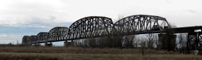
Metropolis Bridge, Railway truss bridge in McCracken County, Kentucky, United States

Metropolis Bridge is a railway structure crossing the Ohio River that joins Metropolis, Illinois to McCracken County, Kentucky. The steel frame rises above the water in a truss design, stretching roughly 2 kilometers (1.2 miles) to link the two regions.

Construction started in 1914 under engineer Ralph Modjeski and the bridge opened for traffic in 1917. This railway project was an important engineering achievement that first linked the two river banks by rail at this location.

The bridge represents early 20th-century industrial development, connecting communities and supporting regional economic growth through railway transportation.

You can view and photograph the bridge from both sides of the Ohio River, especially from the riverside areas where the structure is most visible. The best vantage points are from the access areas along the shore, where you can see the steel framework clearly.

The bridge uses a special pin-connected truss system that was cutting-edge technology when built, allowing the main span to cross the river without any supporting columns in the middle. This engineering approach was an innovation for its time and made the long span possible.

The community of curious travelers

AroundUs brings together thousands of curated places, local tips, and hidden gems, enriched daily by 60,000 contributors worldwide.

Start exploring
Location
Official opening
1917
Length
1,958 m
GPS coordinates
37.14460,-88.74200
Latest update
December 9, 2025 18:40
Around this place
Kincaid Mounds State Historic Site
United States of America

Kincaid Mounds State Historic Site

23.3 km
Olmsted Locks and Dam
United States of America

Olmsted Locks and Dam

28.9 km
Fort Massac
United States of America

Fort Massac

4.9 km
Irvin S. Cobb Bridge
United States of America

Irvin S. Cobb Bridge

10.6 km
United States of America

Honeywell Uranium Hexafluoride Processing Facility

3.3 km
Whitehaven
United States of America

Whitehaven

13.1 km
Dixon Springs State Park
United States of America

Dixon Springs State Park

27.3 km
Lock and Dam Number 52
United States of America

Lock and Dam Number 52

8 km
Cache River State Natural Area
United States of America

Cache River State Natural Area

30.7 km
Smithland Lock and Dam
United States of America

Smithland Lock and Dam

27.9 km
Mermet Lake State Fish and Wildlife Area
United States of America

Mermet Lake State Fish and Wildlife Area

16.3 km
Rowlandton Mound Site
United States of America

Rowlandton Mound Site

10.9 km
Lock and Dam Number 53
United States of America

Lock and Dam Number 53

26.9 km
Heron Pond – Little Black Slough Nature Preserve
United States of America

Heron Pond – Little Black Slough Nature Preserve

30.9 km
Fort Anderson
United States of America

Fort Anderson

13.7 km
Lloyd Tilghman House
United States of America

Lloyd Tilghman House

14.2 km
Lloyd Tilghman Memorial
United States of America

Lloyd Tilghman Memorial

12.9 km
David Yeiser House
United States of America

David Yeiser House

13.9 km
Confederate Monument in Paducah
United States of America

Confederate Monument in Paducah

12.4 km
Elijah P. Curtis House
United States of America

Elijah P. Curtis House

1 km
Masonic Temple
United States of America

Masonic Temple

14.5 km
Kenmil Place
United States of America

Kenmil Place

12.6 km
Richard Olive House
United States of America

Richard Olive House

30 km
Pete Lyles House
United States of America

Pete Lyles House

32.2 km
Barlow House
United States of America

Barlow House

28.9 km
Masonic Hall-Federal Commissary Building
United States of America

Masonic Hall-Federal Commissary Building

29.8 km
Massac Theatre
United States of America

Massac Theatre

1.1 km
Fort Massac State Park
United States of America

Fort Massac State Park

4.9 km
Show the full map
Reviews
Share your experience

No review yet

Discussions
Start a discussion...

No discussion yet

« Metropolis Bridge - Railway truss bridge in McCracken County, Kentucky, United States » is provided by Around Us (aroundus.com). Images and texts are derived from Wikimedia project under a Creative Commons license. You are allowed to copy, distribute, and modify copies of this page, under the conditions set by the license, as long as this note is clearly visible.

Discover hidden gems everywhere you go!

From secret cafés to breathtaking viewpoints, skip the crowded tourist spots and find places that match your style. Our app makes it easy with voice search, smart filtering, route optimization, and insider tips from travelers worldwide. Download now for the complete mobile experience.

Around Us App Screenshot

A unique approach to discovering new places

Le Figaro

All the places worth exploring

France Info

A tailor-made excursion in just a few clicks

20 Minutes

Around Us
Travel Guide & Maps
Download

Send to your phone

QR Code
1

Open the camera app on your mobile.

2

Point at the QR code with your camera. A notification will appear.

3

Tap the notification to open the link.