Olmsted Locks and Dam

Log in to your account

AroundUs is a community-driven map of interesting places, built by curious explorers like you. It grows with every review, story, and photo you share.
Connect to save your favorite spots, contribute locations, and create personalized routes.
By continuing, you accept our Terms and Conditions and our Privacy Policy

Olmsted Locks and Dam

Add to collection
Map
Suggest a change
Share

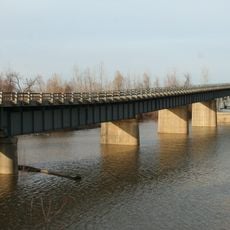
Olmsted Locks and Dam, Lock and dam complex on the Ohio River, Kentucky.

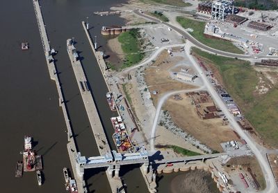
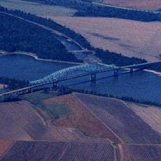
Olmsted Locks and Dam is a lock and dam complex on the Ohio River, near the Kentucky-Illinois border. The two parallel lock chambers each measure around 1,200 feet in length, while the dam stretches roughly 3,575 feet downstream to control water levels.

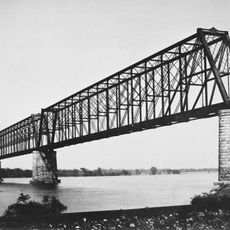
Construction began in the mid-1990s to replace two older locks that were increasingly slowing commercial traffic. The project extended over more than two decades, as technical challenges and funding shifts repeatedly altered the timeline.

The name honors Frederick Law Olmsted, a 19th-century landscape architect who designed Central Park and was later chosen by the Army Corps of Engineers as a tribute. During construction, the facility became a symbol of engineering determination, as navigation never stopped and each phase had to be carefully coordinated with river traffic.

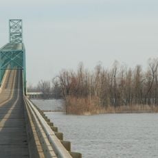
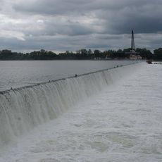
Visitors can observe the facility from nearby vantage points, with the best views of the chambers and dam available on clear days. Since it is an active navigation structure, watch for passing freight barges, which may transit several times each day.

During assembly, massive concrete segments were lowered directly into the flowing water using specialized heavy-lift cranes, without damming the river. This method allowed construction crews to continue work while vessels passed between the emerging structures.

Location: Kentucky

Location: Pulaski County

Part of: locks and dams of the Ohio River

GPS coordinates: 37.18380,-89.06350

Latest update: December 6, 2025 11:00

Photos
Around this place
Cairo Mississippi River Bridge
United States of America

Cairo Mississippi River Bridge

24 km
Metropolis Bridge
United States of America

Metropolis Bridge

28.9 km
Honeywell Uranium Hexafluoride Processing Facility
United States of America

Honeywell Uranium Hexafluoride Processing Facility

27.2 km
Wickliffe Mounds
United States of America

Wickliffe Mounds

23.8 km
Magnolia Manor
United States of America

Magnolia Manor

22.1 km
Cache River
United States of America

Cache River

16.2 km
Cairo Ohio River Bridge
United States of America

Cairo Ohio River Bridge

22.4 km
Cairo Rail Bridge
United States of America

Cairo Rail Bridge

20.5 km
Cache River State Natural Area
United States of America

Cache River State Natural Area

22 km
Cairo I-57 Bridge
United States of America

Cairo I-57 Bridge

22.2 km
Mermet Lake State Fish and Wildlife Area
United States of America

Mermet Lake State Fish and Wildlife Area

20.8 km
Cairo Historic District
United States of America

Cairo Historic District

22.1 km
Lock and Dam Number 53
United States of America

Lock and Dam Number 53

2.9 km
Dogtooth Bend Mounds and Village Site
United States of America

Dogtooth Bend Mounds and Village Site

27.5 km
Heron Pond – Little Black Slough Nature Preserve
United States of America

Heron Pond – Little Black Slough Nature Preserve

22.7 km
Mound City National Cemetery
United States of America

Mound City National Cemetery

14.1 km
Horseshoe Lake
United States of America

Horseshoe Lake

26.1 km
Mound City Civil War Naval Hospital
United States of America

Mound City Civil War Naval Hospital

14.1 km
Elijah P. Curtis House
United States of America

Elijah P. Curtis House

29.5 km
John Bridges Tavern and Store Site
United States of America

John Bridges Tavern and Store Site

28.3 km
Johnson County Courthouse
United States of America

Johnson County Courthouse

29.6 km
Pulaski County Courthouse
United States of America

Pulaski County Courthouse

13.7 km
Ballard County Courthouse
United States of America

Ballard County Courthouse

24.5 km
Barlow House
United States of America

Barlow House

14.8 km
Trimble House
United States of America

Trimble House

23.8 km
Bass Hill Lookout Tower
United States of America

Bass Hill Lookout Tower

27.3 km
Massac Theatre
United States of America

Massac Theatre

29.6 km
Superman statue
United States of America

Superman statue

29.6 km
Show the full map
Reviews

Visited this place? Tap the stars to rate it and share your experience / photos with the community! Try now! You can cancel it anytime.

« Olmsted Locks and Dam - Lock and dam complex on the Ohio River, Kentucky » is provided by Around Us (aroundus.com). Images and texts are derived from Wikimedia project under a Creative Commons license. You are allowed to copy, distribute, and modify copies of this page, under the conditions set by the license, as long as this note is clearly visible.

Discover hidden gems everywhere you go!

From secret cafés to breathtaking viewpoints, skip the crowded tourist spots and find places that match your style. Our app makes it easy with voice search, smart filtering, route optimization, and insider tips from travelers worldwide. Download now for the complete mobile experience.

Around Us App Screenshot

A unique approach to discovering new places

Le Figaro

All the places worth exploring

France Info

A tailor-made excursion in just a few clicks

20 Minutes