Enable Location

We need your location to show you interesting places around you

Discover nearby places

Find interesting locations and hidden gems around you

Precise directions

Get accurate directions and distances to places

Your location is never shared with other users. It's only used when you tap the location button.

Mound City National Cemetery

Log in to your account

Start exploring — it's free

Trusted by 61,916 travelers worldwide

Continue with Google
Continue with Apple
or

We will send you a code to connect

By continuing, you accept our Terms and Conditions and our Privacy Policy

Check your inbox

We've sent a pincode in your inbox. Please enter the code below.

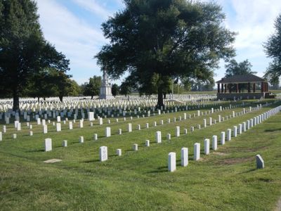
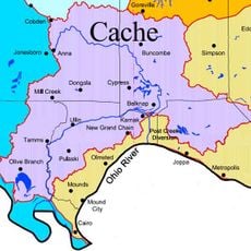
Mound City National Cemetery, Military cemetery in Pulaski County, Illinois, United States

Mound City National Cemetery is a military burial ground located on about 10.5 acres (4 hectares) in southernmost Illinois where over 9,600 soldiers rest. The site sits at the junction of two historic roads and was established to honor those who died serving in the Civil War.

The cemetery was established in 1864 near a naval hospital to serve Union soldiers who died during Civil War campaigns. It became an important repository for the war's fallen as the conflict continued.

The grounds hold the Illinois State Soldiers and Sailors Monument from 1874, which stands as a focal point for remembering fallen troops from the Civil War. This memorial draws visitors seeking to pay respects and understand the site's role as a place of remembrance.

The cemetery grounds are open to visitors from sunrise to sunset daily and are managed by the Jefferson Barracks National Cemetery staff. Visitors should explore respectfully and stay on marked pathways throughout the site.

The burial ground holds the remains of John Basil Turchin, a Russian-born brigadier general who commanded Union forces during the Civil War. His presence reflects the international connections of America's military leadership during that era.

The community of curious travelers

AroundUs brings together thousands of curated places, local tips, and hidden gems, enriched daily by 60,000 contributors worldwide.

Start exploring
Location
Architectural style
Queen Anne style architecture
Phone
GPS coordinates
37.08556,-89.16306
Latest update
December 14, 2025 09:45
Around this place
Olmsted Locks and Dam
United States of America

Olmsted Locks and Dam

14.1 km
Cairo Mississippi River Bridge
United States of America

Cairo Mississippi River Bridge

12 km
Wickliffe Mounds
United States of America

Wickliffe Mounds

14.2 km
Magnolia Manor
United States of America

Magnolia Manor

8.6 km
Cache River
United States of America

Cache River

2.3 km
Cairo Ohio River Bridge
United States of America

Cairo Ohio River Bridge

10.4 km
Cairo Rail Bridge
United States of America

Cairo Rail Bridge

7 km
Cairo I-57 Bridge
United States of America

Cairo I-57 Bridge

8.2 km
Thebes Bridge
United States of America

Thebes Bridge

30.7 km
Turk Site
United States of America

Turk Site

22.3 km
Cairo Historic District
United States of America

Cairo Historic District

9 km
Lock and Dam Number 53
United States of America

Lock and Dam Number 53

16.9 km
Dogtooth Bend Mounds and Village Site
United States of America

Dogtooth Bend Mounds and Village Site

15.4 km
Marshall Site
United States of America

Marshall Site

22 km
Horseshoe Lake
United States of America

Horseshoe Lake

18.4 km
Thebes Courthouse
United States of America

Thebes Courthouse

30.2 km
Thomas J. and Caroline McClure House
United States of America

Thomas J. and Caroline McClure House

35.1 km
Pulaski County Courthouse
United States of America

Pulaski County Courthouse

470 m
Ballard County Courthouse
United States of America

Ballard County Courthouse

15 km
Charles Isaac and Lizzie Hunter Moore Anderson House
United States of America

Charles Isaac and Lizzie Hunter Moore Anderson House

27.3 km
Jacob Swank House
United States of America

Jacob Swank House

25.9 km
Scott County Courthouse
United States of America

Scott County Courthouse

35.6 km
Moore House
United States of America

Moore House

24.6 km
Barlow House
United States of America

Barlow House

11.1 km
Commerce City Hall
United States of America

Commerce City Hall

26.3 km
Trimble House
United States of America

Trimble House

14.4 km
Bass Hill Lookout Tower
United States of America

Bass Hill Lookout Tower

29.7 km
Honey School Lookout Tower
United States of America

Honey School Lookout Tower

23.3 km
Show the full map
« Mound City National Cemetery - Military cemetery in Pulaski County, Illinois, United States » is provided by Around Us (aroundus.com). Images and texts are derived from Wikimedia project under a Creative Commons license. You are allowed to copy, distribute, and modify copies of this page, under the conditions set by the license, as long as this note is clearly visible.

Discover hidden gems everywhere you go!

From secret cafés to breathtaking viewpoints, skip the crowded tourist spots and find places that match your style. Our app makes it easy with voice search, smart filtering, route optimization, and insider tips from travelers worldwide. Download now for the complete mobile experience.

Around Us App Screenshot

A unique approach to discovering new places

Le Figaro

All the places worth exploring

France Info

A tailor-made excursion in just a few clicks

20 Minutes

Around Us
Travel Guide & Maps
Download

Send to your phone

QR Code
1

Open the camera app on your mobile.

2

Point at the QR code with your camera. A notification will appear.

3

Tap the notification to open the link.