Enable Location

We need your location to show you interesting places around you

Discover nearby places

Find interesting locations and hidden gems around you

Precise directions

Get accurate directions and distances to places

Your location is never shared with other users. It's only used when you tap the location button.

Cairo Mississippi River Bridge

Log in to your account

Start exploring — it's free

Trusted by 63,012 travelers worldwide

Continue with Google
Continue with Apple
or

We will send you a code to connect

By continuing, you accept our Terms and Conditions and our Privacy Policy

Check your inbox

We've sent a pincode in your inbox. Please enter the code below.

Cairo Mississippi River Bridge
Discussion Reviews 1 Photos
7.9k Popularity

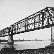
Cairo Mississippi River Bridge, Cantilever bridge across Mississippi River between Missouri and Illinois, United States

The Cairo Mississippi River Bridge is a steel structure spanning approximately 1.8 kilometers across the water, featuring two traffic lanes with a main opening of about 213 meters. The construction rests on foundations built using advanced engineering techniques.

The bridge was built in 1929 by the American Bridge Company of New York, marking a step forward in engineering of that era. The structure was an important addition to regional infrastructure during the years following the Great Depression.

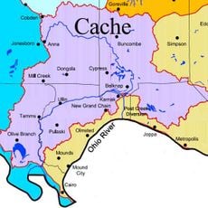
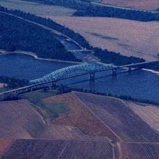
The bridge links communities at the confluence of the Mississippi and Ohio rivers, serving as a vital regional crossing point. It shapes daily life for residents as a central passage between the two river banks.

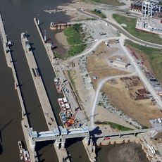
The crossing requires patience with regular maintenance and renovation work that frequently causes closures. Drivers should check the status in advance and know alternative routes to avoid delays.

The crossing is supported by two massive stone piers founded deep into the river, representing a technical achievement of its time. These foundations made the bridge an example of innovative construction methods used in modern infrastructure.

The community of curious travelers

AroundUs brings together thousands of curated places, local tips, and hidden gems, enriched daily by 60,000 contributors worldwide.

Start exploring
Location
Location
Inception
1929
Official opening
1929
GPS coordinates
36.97860,-89.14780
Latest update
December 8, 2025 20:00
Around this place
Olmsted Locks and Dam
United States of America

Olmsted Locks and Dam

24 km
Wickliffe Mounds
United States of America

Wickliffe Mounds

5 km
Magnolia Manor
United States of America

Magnolia Manor

4.6 km
Cache River
United States of America

Cache River

10.1 km
Columbus-Belmont State Park
United States of America

Columbus-Belmont State Park

24 km
Cairo Ohio River Bridge
United States of America

Cairo Ohio River Bridge

1.7 km
Cairo Rail Bridge
United States of America

Cairo Rail Bridge

5.5 km
Towosahgy State Historic Site
United States of America

Towosahgy State Historic Site

32.7 km
Cairo I-57 Bridge
United States of America

Cairo I-57 Bridge

7.5 km
Turk Site
United States of America

Turk Site

10.9 km
Cairo Historic District
United States of America

Cairo Historic District

3.8 km
Lock and Dam Number 53
United States of America

Lock and Dam Number 53

26.5 km
Dogtooth Bend Mounds and Village Site
United States of America

Dogtooth Bend Mounds and Village Site

19.1 km
Mound City National Cemetery
United States of America

Mound City National Cemetery

12 km
Marshall Site
United States of America

Marshall Site

10.6 km
Horseshoe Lake
United States of America

Horseshoe Lake

26.4 km
Marvin College Boys Dormitory and President's House
United States of America

Marvin College Boys Dormitory and President's House

36.8 km
Mound City Civil War Naval Hospital
United States of America

Mound City Civil War Naval Hospital

12 km
Thebes Courthouse
United States of America

Thebes Courthouse

38.5 km
George W. Stone House
United States of America

George W. Stone House

30 km
Pulaski County Courthouse
United States of America

Pulaski County Courthouse

12.4 km
Ballard County Courthouse
United States of America

Ballard County Courthouse

5.5 km
Charles Isaac and Lizzie Hunter Moore Anderson House
United States of America

Charles Isaac and Lizzie Hunter Moore Anderson House

34.2 km
Jacob Swank House
United States of America

Jacob Swank House

20.8 km
Moore House
United States of America

Moore House

19 km
Barlow House
United States of America

Barlow House

12.2 km
Commerce City Hall
United States of America

Commerce City Hall

33.1 km
Trimble House
United States of America

Trimble House

5.3 km
Show the full map
Reviews
Share your experience

No review yet

Discussions
Start a discussion...

No discussion yet

« Cairo Mississippi River Bridge - Cantilever bridge across Mississippi River between Missouri and Illinois, United States » is provided by Around Us (aroundus.com). Images and texts are derived from Wikimedia project under a Creative Commons license. You are allowed to copy, distribute, and modify copies of this page, under the conditions set by the license, as long as this note is clearly visible.

Discover hidden gems everywhere you go!

From secret cafés to breathtaking viewpoints, skip the crowded tourist spots and find places that match your style. Our app makes it easy with voice search, smart filtering, route optimization, and insider tips from travelers worldwide. Download now for the complete mobile experience.

Around Us App Screenshot

A unique approach to discovering new places

Le Figaro

All the places worth exploring

France Info

A tailor-made excursion in just a few clicks

20 Minutes

Around Us
Travel Guide & Maps
Download

Send to your phone

QR Code
1

Open the camera app on your mobile.

2

Point at the QR code with your camera. A notification will appear.

3

Tap the notification to open the link.