Enable Location

We need your location to show you interesting places around you

Discover nearby places

Find interesting locations and hidden gems around you

Precise directions

Get accurate directions and distances to places

Your location is never shared with other users. It's only used when you tap the location button.

Mermet Lake State Fish and Wildlife Area

Log in to your account

Start exploring — it's free

Trusted by 61,931 travelers worldwide

Continue with Google
Continue with Apple
or

We will send you a code to connect

By continuing, you accept our Terms and Conditions and our Privacy Policy

Check your inbox

We've sent a pincode in your inbox. Please enter the code below.

Mermet Lake State Fish and Wildlife Area

Mermet Lake State Fish and Wildlife Area, Protected wetland and wildlife area in Massac County, Illinois.

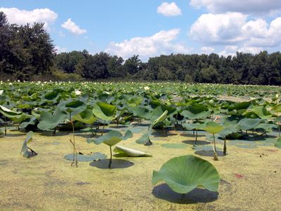
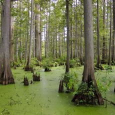
Mermet Lake State Fish and Wildlife Area is a conservation area in Illinois spanning about 2,630 acres of land and 690 acres of water, with old cypress swamps, waterfowl, and fish populations. The location includes four boat launches for fishing access and more than 30 permanent hunting blinds for waterfowl, deer, and small game pursuits.

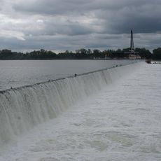
The Illinois Department of Natural Resources acquired this land in 1949 to establish it as a conservation area. In 1962, officials constructed levees that reshaped the landscape and created the lake configuration seen today.

This site hosts one of the largest archery competitions in the nation, the Pro/Am National Archery Tournament, held annually in late June. The competition draws visitors from across the country and transforms the area into a gathering place for archers and sports enthusiasts.

The area is best accessed by bringing your own boat or visiting by car, as multiple entry points provide convenient access. Most activities require permits and follow specific seasonal schedules, so checking current regulations before your visit helps you plan accordingly.

The area maintains a well and pump system to regulate water levels after duck season ends. This system helps sustain both aquatic habitats and recreational opportunities throughout the year.

The community of curious travelers

AroundUs brings together thousands of curated places, local tips, and hidden gems, enriched daily by 60,000 contributors worldwide.

Start exploring
Location
GPS coordinates
37.26220,-88.85060
Latest update
December 13, 2025 11:46
Around this place
Olmsted Locks and Dam
United States of America

Olmsted Locks and Dam

20.8 km
Fort Massac
United States of America

Fort Massac

19.6 km
Irvin S. Cobb Bridge
United States of America

Irvin S. Cobb Bridge

25.6 km
Metropolis Bridge
United States of America

Metropolis Bridge

16.3 km
United States of America

Honeywell Uranium Hexafluoride Processing Facility

13 km
Whitehaven
United States of America

Whitehaven

29.4 km
Ferne Clyffe State Park
United States of America

Ferne Clyffe State Park

32 km
Dixon Springs State Park
United States of America

Dixon Springs State Park

21.2 km
Lock and Dam Number 52
United States of America

Lock and Dam Number 52

23.3 km
Cache River State Natural Area
United States of America

Cache River State Natural Area

14.5 km
Rowlandton Mound Site
United States of America

Rowlandton Mound Site

26.6 km
Lock and Dam Number 53
United States of America

Lock and Dam Number 53

18 km
Heron Pond – Little Black Slough Nature Preserve
United States of America

Heron Pond – Little Black Slough Nature Preserve

14.6 km
Fort Anderson
United States of America

Fort Anderson

29 km
Lloyd Tilghman House
United States of America

Lloyd Tilghman House

29.7 km
Lloyd Tilghman Memorial
United States of America

Lloyd Tilghman Memorial

28.7 km
David Yeiser House
United States of America

David Yeiser House

29.3 km
Vienna Public Library
United States of America

Vienna Public Library

17.6 km
Confederate Monument in Paducah
United States of America

Confederate Monument in Paducah

28.1 km
Elijah P. Curtis House
United States of America

Elijah P. Curtis House

16.1 km
John Bridges Tavern and Store Site
United States of America

John Bridges Tavern and Store Site

24.1 km
Johnson County Courthouse
United States of America

Johnson County Courthouse

17.4 km
Masonic Temple
United States of America

Masonic Temple

30.1 km
Kenmil Place
United States of America

Kenmil Place

28.9 km
Barlow House
United States of America

Barlow House

29.2 km
Massac Theatre
United States of America

Massac Theatre

16.2 km
Fort Massac State Park
United States of America

Fort Massac State Park

19.6 km
Superman statue
United States of America

Superman statue

16.1 km
Show the full map
« Mermet Lake State Fish and Wildlife Area - Protected wetland and wildlife area in Massac County, Illinois » is provided by Around Us (aroundus.com). Images and texts are derived from Wikimedia project under a Creative Commons license. You are allowed to copy, distribute, and modify copies of this page, under the conditions set by the license, as long as this note is clearly visible.

Discover hidden gems everywhere you go!

From secret cafés to breathtaking viewpoints, skip the crowded tourist spots and find places that match your style. Our app makes it easy with voice search, smart filtering, route optimization, and insider tips from travelers worldwide. Download now for the complete mobile experience.

Around Us App Screenshot

A unique approach to discovering new places

Le Figaro

All the places worth exploring

France Info

A tailor-made excursion in just a few clicks

20 Minutes

Around Us
Travel Guide & Maps
Download

Send to your phone

QR Code
1

Open the camera app on your mobile.

2

Point at the QR code with your camera. A notification will appear.

3

Tap the notification to open the link.