Lake McConaughy, Reservoir in Ogallala, United States
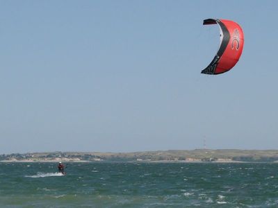
Lake McConaughy is a large reservoir near Ogallala in western Nebraska, covering more than 14,000 hectares with a shoreline stretching over 120 kilometers. At its deepest point near Kingsley Dam, the water reaches a depth of about 43 meters (142 feet).
Construction of the reservoir began in 1936 during the Great Depression and was completed five years later, funded through a large federal program for irrigation and power generation. The dam and water basin became part of a wider project to supply water to farming lands in Nebraska.
The reservoir takes its name from a grain merchant who once served as mayor of Holdrege and worked to expand irrigation farming in the region. Today locals use the water for fishing, swimming and water sports, while many visitors set up tents along the shore.
Anyone planning to camp should book early, especially during summer months between May and September when most visitors gather along the shore. Overnight stays directly on the beach require shorter lead times, while established campgrounds often fill up months in advance.
A tower-shaped spillway called Morning Glory channels water from the lake into a hydroelectric plant and then onward to a smaller lake downstream. This design allows controlled water release even when water levels shift considerably.
The community of curious travelers
AroundUs brings together thousands of curated places, local tips, and hidden gems, enriched daily by 60,000 contributors worldwide.