O'Fallons Bluff, Historic site near Sutherland, Nebraska.
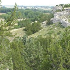
O'Fallons Bluff is a historic site in Nebraska with cliffs extending roughly 20 miles along the south side of the Platte River. The bluffs display visible wagon ruts carved into the landscape by pioneers during their westward migration.
This site became a critical point on the Oregon Trail route in 1846 when the Donner Party passed through on their difficult journey to California. The location marks a key segment of 19th-century westward expansion.
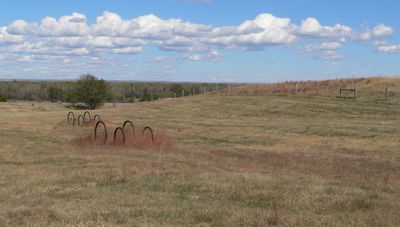
Iron hoops at the Sutherland Rest Area mark where wagon wheels once carved paths across the land during 19th-century westward migration. These markers help visitors understand the routes that settlers followed.
The site is accessible via the eastbound lanes of Interstate 80 at the Sutherland Rest Area, which features interpretive panels, restrooms, and basic facilities. Visitors should use marked areas and watch for uneven ground when exploring the terrain.
Archaeological excavations in 1966 searched for military fortifications from the 1860s but uncovered mainly animal bones in the surrounding area. This discovery shows the site has been studied for longer than many visitors realize.
Location: Nebraska
GPS coordinates: 41.13640,-101.09500
Latest update: December 14, 2025 11:00
Lake McConaughy
53 km
Ash Hollow State Historical Park
87.7 km
Buffalo Bill Ranch
25.3 km
Fort McPherson
50.2 km
Fort McPherson National Cemetery
49.3 km
Pilgrim Holiness Church
69.3 km
First Arthur County Courthouse and Jail
69.3 km
Wallace W. Waterman Sod House
82.2 km
Golden Spike Tower and Visitor Center
22.3 km
St. John's Evangelical Lutheran German Church and Cemetery
66.7 km
Grant City Park
61.8 km
Lewellen State Aid Bridge
90 km
Texas Trail Stone Corral
75.3 km
Neville Center for the Performing Arts
28 km
Leonidas A. Brandhoefer Mansion
52.4 km
Grant Commercial Historic District
62.3 km
Lincoln County Courthouse
27.9 km
Perkins County Courthouse
62.4 km
Ernest A. Calling House
81.7 km
Dr. Burdette and Myrna Gainsforth House
52.3 km
Johnston Memorial Building
33.6 km
Chase County Courthouse
82.6 km
Sutherland State Aid Bridge
11.7 km
Gothenburg Carnegie Library
81.8 km
Diamond Springs Stage Station Site
68.3 kmHighland Precinct
85.6 km
Union Pacific 6922
28.7 km
Union Pacific 3977
28.7 kmVisited this place? Tap the stars to rate it and share your experience / photos with the community! Try now! You can cancel it anytime.
Discover hidden gems everywhere you go!
From secret cafés to breathtaking viewpoints, skip the crowded tourist spots and find places that match your style. Our app makes it easy with voice search, smart filtering, route optimization, and insider tips from travelers worldwide. Download now for the complete mobile experience.
A unique approach to discovering new places❞
— Le Figaro
All the places worth exploring❞
— France Info
A tailor-made excursion in just a few clicks❞
— 20 Minutes