Enable Location

We need your location to show you interesting places around you

Discover nearby places

Find interesting locations and hidden gems around you

Precise directions

Get accurate directions and distances to places

Your location is never shared with other users. It's only used when you tap the location button.

Fort McPherson National Cemetery

Log in to your account

Start exploring — it's free

Trusted by 65,448 travelers worldwide

Continue with Google
Continue with Apple
or

We will send you a code to connect

By continuing, you accept our Terms and Conditions and our Privacy Policy

Check your inbox

We've sent a pincode in your inbox. Please enter the code below.

Discussion Reviews 1 Photos
3.3k Popularity

Fort McPherson National Cemetery, Military cemetery in Lincoln County, Nebraska

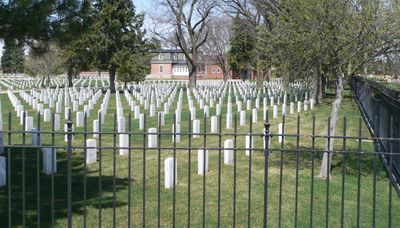
Fort McPherson National Cemetery is a federal military burial ground in Lincoln County, Nebraska, located near the town of Maxwell. The grounds are laid out in rows of white headstones on open land, with a small number of monuments and an administration building near the entrance.

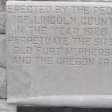
The cemetery was established in 1863 to bury soldiers who died along the Oregon and California Trails. Over the following decades, remains from more than 20 deactivated frontier forts across the region were moved here.

The cemetery holds graves of Buffalo Soldiers from the 9th and 10th Cavalry, African American men who served on the western frontier after the Civil War. Their white headstones stand in the same rows as all the others, with no visible distinction from the rest.

The cemetery is open daily from sunrise to sunset, and signs throughout the grounds help with orientation. Visiting on a weekday outside summer tends to be quieter and allows more time to walk the rows at your own pace.

A marble monument on the grounds marks the graves of soldiers who died in the Grattan Fight of 1854, a clash between a small US Army detachment and Lakota warriors. It is one of the earliest armed confrontations of its kind in the region and remains largely unknown outside specialist circles.

The community of curious travelers

AroundUs brings together thousands of curated places, local tips, and hidden gems, enriched daily by 60,000 contributors worldwide.

Start exploring
Location
Inception
1863
GPS coordinates
41.02495,-100.52578
Latest update
March 3, 2026 13:58
Around this place
Buffalo Bill Ranch
United States of America

Buffalo Bill Ranch

27.3 km
Fort McPherson
United States of America

Fort McPherson

1.2 km
Heartland Museum of Military Vehicles
United States of America

Heartland Museum of Military Vehicles

73.4 km
O'Fallons Bluff
United States of America

O'Fallons Bluff

49.3 km
St. Anselm's Catholic Church, Rectory and Parish Hall
United States of America

St. Anselm's Catholic Church, Rectory and Parish Hall

85.8 km
Golden Spike Tower and Visitor Center
United States of America

Golden Spike Tower and Visitor Center

28.7 km
St. John's Evangelical Lutheran German Church and Cemetery
United States of America

St. John's Evangelical Lutheran German Church and Cemetery

57.2 km
W. H. Faling House
United States of America

W. H. Faling House

88 km
Mowry Bluff Archeological Site
United States of America

Mowry Bluff Archeological Site

77 km
Neville Center for the Performing Arts
United States of America

Neville Center for the Performing Arts

23.3 km
Dawson County Courthouse
United States of America

Dawson County Courthouse

71.5 km
Gosper County Courthouse
United States of America

Gosper County Courthouse

74.2 km
Allen's Opera House
United States of America

Allen's Opera House

49 km
Lincoln County Courthouse
United States of America

Lincoln County Courthouse

23.4 km
Ernest A. Calling House
United States of America

Ernest A. Calling House

32.4 km
Ira Webster Olive House
United States of America

Ira Webster Olive House

71.5 km
Johnston Memorial Building
United States of America

Johnston Memorial Building

57.5 km
Custer County Courthouse
United States of America

Custer County Courthouse

58.7 km
Sutherland State Aid Bridge
United States of America

Sutherland State Aid Bridge

44.7 km
Gothenburg Carnegie Library
United States of America

Gothenburg Carnegie Library

32.5 km
Custer County Courthouse
United States of America

Custer County Courthouse

85.1 km
Brenizer Library
United States of America

Brenizer Library

81.9 km
Broken Bow Carnegie Library
United States of America

Broken Bow Carnegie Library

85.2 km
United States of America

Highland Precinct

75.1 km
Union Pacific 6922
United States of America

Union Pacific 6922

23.4 km
Union Pacific 3977
United States of America

Union Pacific 3977

23.5 km
Tiffany Theater
United States of America

Tiffany Theater

85.2 km
Harry V. Temple House
United States of America

Harry V. Temple House

71.4 km
Show the full map
Reviews
Share your experience

No review yet

Discussions
Start a discussion...

No discussion yet

« Fort McPherson National Cemetery - Military cemetery in Lincoln County, Nebraska » is provided by Around Us (aroundus.com). Images and texts are derived from Wikimedia project under a Creative Commons license. You are allowed to copy, distribute, and modify copies of this page, under the conditions set by the license, as long as this note is clearly visible.

Discover hidden gems everywhere you go!

From secret cafés to breathtaking viewpoints, skip the crowded tourist spots and find places that match your style. Our app makes it easy with voice search, smart filtering, route optimization, and insider tips from travelers worldwide. Download now for the complete mobile experience.

Around Us App Screenshot

A unique approach to discovering new places

Le Figaro

All the places worth exploring

France Info

A tailor-made excursion in just a few clicks

20 Minutes

Around Us
Travel Guide & Maps
Download

Send to your phone

QR Code
1

Open the camera app on your mobile.

2

Point at the QR code with your camera. A notification will appear.

3

Tap the notification to open the link.