Enable Location

We need your location to show you interesting places around you

Discover nearby places

Find interesting locations and hidden gems around you

Precise directions

Get accurate directions and distances to places

Your location is never shared with other users. It's only used when you tap the location button.

St. John's Evangelical Lutheran German Church and Cemetery

Log in to your account

Start exploring — it's free

Trusted by 61,516 travelers worldwide

Continue with Google
Continue with Apple
or

We will send you a code to connect

By continuing, you accept our Terms and Conditions and our Privacy Policy

Check your inbox

We've sent a pincode in your inbox. Please enter the code below.

St. John's Evangelical Lutheran German Church and Cemetery

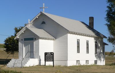
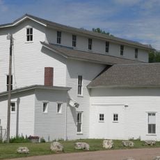
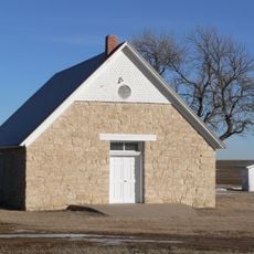
St. John's Evangelical Lutheran German Church and Cemetery, Lutheran church and cemetery near Hayes Center, Nebraska.

Description

St. John's Evangelical Lutheran German Church is a white wooden building in Nebraska standing beside a cemetery that spans about 10 acres. The church structure was built in 1925 and features stained glass windows that were added later.

History

The congregation started in 1886 with a sod building before the current wooden church was built in 1925. This structure became an important gathering place for the German-speaking settlers who had moved to the area.

Culture

The gravestones in the cemetery display names and stories of generations from German-speaking families who settled across this rural region. Visitors can trace through the inscriptions how this community grew and maintained its heritage over the decades.

Practical

The building sits in a rural setting and is easy to spot from a distance, though it is located in an out-of-the-way location. Visitors should be aware that the site is now managed by the Nebraska State Historical Society and access may be limited.

Did you know?

The building was designed by Bill Miller and shows the distinctive architecture of rural churches on the Great Plains, with clean lines and practical design. This type of structure was directly adapted to the living conditions of the farmers who established the community.

Location
Made from material
wood
GPS coordinates
40.56947,-100.83970
Latest update
December 14, 2025 18:15

AroundUs brings together thousands of curated places, local tips, and hidden gems, enriched daily by 60,000 contributors worldwide. Discover all places nearby (Nebraska).

Around this place
Buffalo Bill Ranch
United States of America

Buffalo Bill Ranch

66.2 km
Harvey P. Sutton House
United States of America

Harvey P. Sutton House

44.6 km
Fort McPherson
United States of America

Fort McPherson

56.7 km
Fort McPherson National Cemetery
United States of America

Fort McPherson National Cemetery

57.2 km
O'Fallons Bluff
United States of America

O'Fallons Bluff

66.7 km
Golden Spike Tower and Visitor Center
United States of America

Golden Spike Tower and Visitor Center

64 km
George W. Norris House
United States of America

George W. Norris House

44.5 km
Massacre Canyon Historical Monument
United States of America

Massacre Canyon Historical Monument

41.8 km
Champion Mill
United States of America

Champion Mill

77.9 km
St. Paul's Methodist Protestant Church
United States of America

St. Paul's Methodist Protestant Church

50.7 km
W. H. Faling House
United States of America

W. H. Faling House

65.2 km
Texas Trail Stone Corral
United States of America

Texas Trail Stone Corral

66.6 km
Mowry Bluff Archeological Site
United States of America

Mowry Bluff Archeological Site

56.6 km
Neville Center for the Performing Arts
United States of America

Neville Center for the Performing Arts

63.5 km
Ideal Cement bridge (Stratton, Nebraska)
United States of America

Ideal Cement bridge (Stratton, Nebraska)

55.2 km
McCook Public-Carnegie Library
United States of America

McCook Public-Carnegie Library

44.8 km
Lincoln County Courthouse
United States of America

Lincoln County Courthouse

63.4 km
Allen's Opera House
United States of America

Allen's Opera House

79 km
Ernest A. Calling House
United States of America

Ernest A. Calling House

70.2 km
Red Willow County Courthouse
United States of America

Red Willow County Courthouse

44.8 km
Johnston Memorial Building
United States of America

Johnston Memorial Building

40.6 km
McCook YMCA
United States of America

McCook YMCA

44.8 km
Chase County Courthouse
United States of America

Chase County Courthouse

68.2 km
Sutherland State Aid Bridge
United States of America

Sutherland State Aid Bridge

72.7 km
Gothenburg Carnegie Library
United States of America

Gothenburg Carnegie Library

69.9 km
United States of America

Highland Precinct

19.7 km
Union Pacific 6922
United States of America

Union Pacific 6922

64.8 km
Union Pacific 3977
United States of America

Union Pacific 3977

64.8 km
Show the full map
« St. John's Evangelical Lutheran German Church and Cemetery - Lutheran church and cemetery near Hayes Center, Nebraska » is provided by Around Us (aroundus.com). Images and texts are derived from Wikimedia project under a Creative Commons license. You are allowed to copy, distribute, and modify copies of this page, under the conditions set by the license, as long as this note is clearly visible.

Discover hidden gems everywhere you go!

From secret cafés to breathtaking viewpoints, skip the crowded tourist spots and find places that match your style. Our app makes it easy with voice search, smart filtering, route optimization, and insider tips from travelers worldwide. Download now for the complete mobile experience.

Around Us App Screenshot

A unique approach to discovering new places

Le Figaro

All the places worth exploring

France Info

A tailor-made excursion in just a few clicks

20 Minutes

Around Us
Travel Guide & Maps
Download

Send to your phone

QR Code
1

Open the camera app on your mobile.

2

Point at the QR code with your camera. A notification will appear.

3

Tap the notification to open the link.