Enable Location

We need your location to show you interesting places around you

Discover nearby places

Find interesting locations and hidden gems around you

Precise directions

Get accurate directions and distances to places

Your location is never shared with other users. It's only used when you tap the location button.

Lane Bane Bridge

Log in to your account

Start exploring — it's free

Trusted by 61,365 travelers worldwide

Continue with Google
Continue with Apple
or

We will send you a code to connect

By continuing, you accept our Terms and Conditions and our Privacy Policy

Check your inbox

We've sent a pincode in your inbox. Please enter the code below.

Lane Bane Bridge

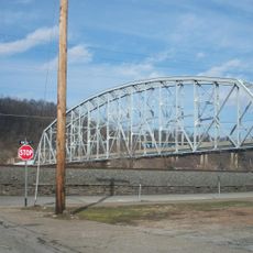
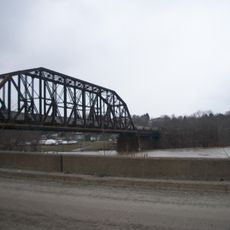
Lane Bane Bridge, Truss bridge across Monongahela River in Brownsville, Pennsylvania

Description

Lane Bane Bridge is a steel truss structure that crosses the Monongahela River and connects Brownsville with West Brownsville. It carries US Route 40 with four divided lanes for traffic passing through the region.

History

The bridge was completed in 1960 as part of the Mon-Fayette Expressway infrastructure development. This construction was a key step in modernizing transportation connections in the Fayette County region.

Culture

The Lane Bane Bridge functions as a central connector between communities in Fayette County, enabling daily commutes and strengthening regional connections.

Practical

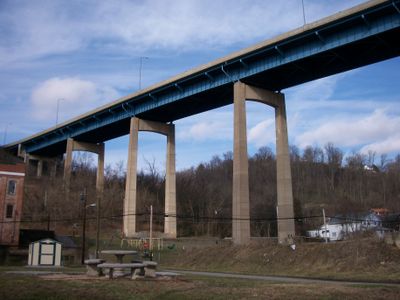
The bridge sits elevated above the valley floor, allowing it to cross the terrain without major deviations. A 3-mile freeway segment extends from its western bank, providing continuous road connections.

Did you know?

The bridge structure maintains a specific elevation to avoid entering the deep valley of the region while spanning 518 feet across its longest section.

Location
Inception
1960
Official opening
1960
GPS coordinates
40.02500,-79.88510
Latest update
December 14, 2025 11:00

AroundUs brings together thousands of curated places, local tips, and hidden gems, enriched daily by 60,000 contributors worldwide. Discover all places nearby (Pennsylvania).

Around this place
Bowman's Castle
United States of America

Bowman's Castle

297 m
Dunlap's Creek Bridge
United States of America

Dunlap's Creek Bridge

449 m
Brownsville Bridge
United States of America

Brownsville Bridge

502 m
Penn-Craft Historic District
United States of America

Penn-Craft Historic District

7.7 km
Francis Farm Petroglyphs
United States of America

Francis Farm Petroglyphs

8.4 km
Peter Colley Tavern and Barn
United States of America

Peter Colley Tavern and Barn

6.8 km
Oak Hill Estate
United States of America

Oak Hill Estate

5.9 km
Wallace-Baily Tavern
United States of America

Wallace-Baily Tavern

4.5 km
Old Main
United States of America

Old Main

4.5 km
Brownsville Northside Historic District
United States of America

Brownsville Northside Historic District

503 m
Brier Hill
United States of America

Brier Hill

6.9 km
Molly Fleming House
United States of America

Molly Fleming House

4.3 km
California Area Public Library
United States of America

California Area Public Library

4.8 km
Centerville Historic District
United States of America

Centerville Historic District

8.1 km
Thomas H. Thompson House
United States of America

Thomas H. Thompson House

1.9 km
Jennings-Gallagher House
United States of America

Jennings-Gallagher House

4.4 km
Joseph Dorsey House
United States of America

Joseph Dorsey House

3.3 km
West Brownsville Junction Bridge
United States of America

West Brownsville Junction Bridge

1.2 km
Brownsville Commercial Historic District
United States of America

Brownsville Commercial Historic District

432 m
Harrison House
United States of America

Harrison House

6 km
Springer Farm
United States of America

Springer Farm

5.9 km
Hugh Laughlin House
United States of America

Hugh Laughlin House

4.8 km
Johnson-Hatfield Tavern
United States of America

Johnson-Hatfield Tavern

7.8 km
Brown-Moore Blacksmith Shop
United States of America

Brown-Moore Blacksmith Shop

5.9 km
Arboreto de la universidad de California en Pensilvania
United States of America

Arboreto de la universidad de California en Pensilvania

4.7 km
National Pike Steam Gas and Horse Association
United States of America

National Pike Steam Gas and Horse Association

4.6 km
Hepner–Bailey Field at Adamson Stadium
United States of America

Hepner–Bailey Field at Adamson Stadium

2.9 km
Maxwell Lock & Dam
United States of America

Maxwell Lock & Dam

6.9 km
Show the full map
« Lane Bane Bridge - Truss bridge across Monongahela River in Brownsville, Pennsylvania » is provided by Around Us (aroundus.com). Images and texts are derived from Wikimedia project under a Creative Commons license. You are allowed to copy, distribute, and modify copies of this page, under the conditions set by the license, as long as this note is clearly visible.

Discover hidden gems everywhere you go!

From secret cafés to breathtaking viewpoints, skip the crowded tourist spots and find places that match your style. Our app makes it easy with voice search, smart filtering, route optimization, and insider tips from travelers worldwide. Download now for the complete mobile experience.

Around Us App Screenshot

A unique approach to discovering new places

Le Figaro

All the places worth exploring

France Info

A tailor-made excursion in just a few clicks

20 Minutes

Around Us
Travel Guide & Maps
Download

Send to your phone

QR Code
1

Open the camera app on your mobile.

2

Point at the QR code with your camera. A notification will appear.

3

Tap the notification to open the link.