Enable Location

We need your location to show you interesting places around you

Discover nearby places

Find interesting locations and hidden gems around you

Precise directions

Get accurate directions and distances to places

Your location is never shared with other users. It's only used when you tap the location button.

Log in to your account

Start exploring — it's free

Trusted by 61,976 travelers worldwide

Continue with Google
Continue with Apple
or

We will send you a code to connect

By continuing, you accept our Terms and Conditions and our Privacy Policy

Check your inbox

We've sent a pincode in your inbox. Please enter the code below.

Lower Hatchie National Wildlife Refuge

Lower Hatchie National Wildlife Refuge, National wildlife refuge at Mississippi River confluence in Lauderdale County, US

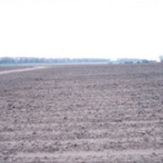
Lower Hatchie National Wildlife Refuge is a protected area where the Hatchie River approaches the Mississippi in western Tennessee, comprising bottomland forests, wetlands, and open fields. The refuge spans more than 11000 acres and supports multiple habitats that attract migratory waterfowl and other wildlife throughout the year.

The refuge was established in 1980 as a protected space for migratory birds along the natural Hatchie River in the Mississippi region. Its creation was part of a national effort to safeguard critical wetland habitats and support bird populations that depend on these ecosystems.

The Junior Duck Stamp Art Contest at Lower Hatchie National Wildlife Refuge connects students from kindergarten through high school with nature through artistic expression.

The observation tower works best in winter months for viewing waterfowl in flooded fields, while kayaking on Champion Lake is more pleasant during warmer seasons. Plan your visit based on which activity interests you most, since conditions and access change throughout the year.

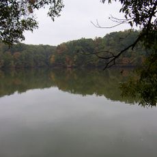
The Hatchie River within this refuge follows its original unaltered course, offering a rare look at natural river flow that remains largely unchanged by human intervention. This natural movement of water creates a living example of how rivers work without dams or major modifications.

The community of curious travelers

AroundUs brings together thousands of curated places, local tips, and hidden gems, enriched daily by 60,000 contributors worldwide.

Start exploring
Inception
1980
GPS coordinates
35.58330,-89.86670
Latest update
December 14, 2025 11:20
Around this place
Memphis International Raceway
United States of America

Memphis International Raceway

34.2 km
Farm No. 266—Johnny Cash Boyhood Home
United States of America

Farm No. 266—Johnny Cash Boyhood Home

34.3 km
Fort Pillow State Park
United States of America

Fort Pillow State Park

6.3 km
Meeman-Shelby Forest State Park
United States of America

Meeman-Shelby Forest State Park

31.9 km
Nodena Site
United States of America

Nodena Site

8.3 km
Davies Manor
United States of America

Davies Manor

41.2 km
Alex Haley House and Museum
United States of America

Alex Haley House and Museum

28.1 km
Memphis Tennessee Temple
United States of America

Memphis Tennessee Temple

38.2 km
Hampson Archeological Museum State Park
United States of America

Hampson Archeological Museum State Park

15.8 km
Nicholas Gotten House
United States of America

Nicholas Gotten House

42 km
Mississippi County Courthouse
United States of America

Mississippi County Courthouse

16.2 km
Mississippi County Courthouse
United States of America

Mississippi County Courthouse

38.6 km
Kress Building
United States of America

Kress Building

38.4 km
Hotel Lindo
United States of America

Hotel Lindo

20 km
Bank of Osceola
United States of America

Bank of Osceola

16.1 km
City Hall
United States of America

City Hall

16.3 km
Lauderdale County Courthouse
United States of America

Lauderdale County Courthouse

35.4 km
Osceola Times Building
United States of America

Osceola Times Building

16.2 km
Keiser Water Tower
United States of America

Keiser Water Tower

23.3 km
Keiser School
United States of America

Keiser School

23 km
Hale Avenue Historic District
United States of America

Hale Avenue Historic District

16.2 km
West Main Street Residential Historic District
United States of America

West Main Street Residential Historic District

38.5 km
Wilson Residential Historic District
United States of America

Wilson Residential Historic District

15.1 km
Florida Brothers Building
United States of America

Florida Brothers Building

16.3 km
Wilson Community House
United States of America

Wilson Community House

15.9 km
Chris Tompkins House
United States of America

Chris Tompkins House

26.7 km
Johnny Cash Boyhood Home
United States of America

Johnny Cash Boyhood Home

34.3 km
Fort Pillow State Historic Park
United States of America

Fort Pillow State Historic Park

5.7 km
Show the full map
« Lower Hatchie National Wildlife Refuge - National wildlife refuge at Mississippi River confluence in Lauderdale County, US » is provided by Around Us (aroundus.com). Images and texts are derived from Wikimedia project under a Creative Commons license. You are allowed to copy, distribute, and modify copies of this page, under the conditions set by the license, as long as this note is clearly visible.

Discover hidden gems everywhere you go!

From secret cafés to breathtaking viewpoints, skip the crowded tourist spots and find places that match your style. Our app makes it easy with voice search, smart filtering, route optimization, and insider tips from travelers worldwide. Download now for the complete mobile experience.

Around Us App Screenshot

A unique approach to discovering new places

Le Figaro

All the places worth exploring

France Info

A tailor-made excursion in just a few clicks

20 Minutes

Around Us
Travel Guide & Maps
Download

Send to your phone

QR Code
1

Open the camera app on your mobile.

2

Point at the QR code with your camera. A notification will appear.

3

Tap the notification to open the link.