Farm No. 266—Johnny Cash Boyhood Home
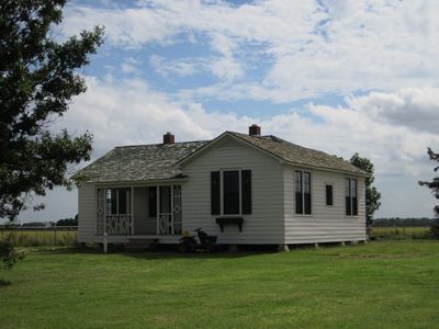
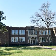
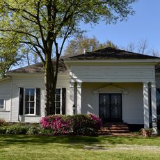
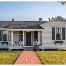
Farm No. 266—Johnny Cash Boyhood Home, Historic farmhouse in Dyess, Arkansas.
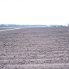
The five-room farmhouse at 110 Center Drive features white wooden siding, original furnishings, and cotton fields that extend across the surrounding landscape.
The Federal Emergency Relief Administration constructed Farm No. 266 in 1934 as part of a New Deal initiative to support struggling farmers during the Great Depression.
Johnny Cash spent his formative years from ages three to eighteen in this house, where daily experiences of cotton farming influenced his future musical compositions.
Arkansas State University operates guided tours of the restored property, allowing visitors to explore the furnished rooms and learn about agricultural life in the 1930s.
The Mississippi River floods that forced the Cash family to evacuate their home provided direct inspiration for the song 'Five Feet High and Rising'.
Location: Mississippi County
Website: http://dyesscash.astate.edu
GPS coordinates: 35.59739,-90.24499
Latest update: September 23, 2025 14:24
Arkansas sits in the southern United States, where the Ozark and Ouachita mountains meet forested valleys and slow rivers. Away from the main highways, the state holds waterfalls hidden in national forests, abandoned settlements from mining days, and caves filled with limestone formations. Haw Creek Falls drops over a series of ledges in the Ozarks, while Blanchard Springs Caverns opens into chambers where underground streams have carved stone over thousands of years. Rush, once a zinc mining town, now stands empty along the Buffalo River. Boxley Valley offers open fields where elk graze beneath ridges, and the Cossatot River cuts through rocky rapids in the Ouachita range. These places show different chapters of the region's natural and human history. Historical sites and cultural centers add depth to the landscape. Monte Ne preserves the ruins of an early resort built beside Beaver Lake. The Hampson Archeological Museum holds artifacts from indigenous peoples who lived in the Mississippi River floodplain. Jacksonport once served as a river port on the White River, and the Delta Cultural Center documents the agricultural heritage of eastern Arkansas. From Sam's Throne, a rock outcrop with views across the Ozarks, to the old railway bridge in Clarendon, these locations lie off the usual routes and reward those who take the time to seek them out.
Meeman-Shelby Forest State Park
32.8 km
Nodena Site
27 km
Hampson Archeological Museum State Park
18.8 km
Herman Davis State Park
31.5 km
St. Francis River Bridge
30.1 km
Marked Tree Lock and Siphons
16.8 km
Mississippi County Courthouse
27.6 km
Maxie Theatre
25.9 km
Tyronza Water Tower
15.7 km
Judd Hill Cotton Gin
24.8 km
Bank of Osceola
27.8 km
City Hall
27.4 km
Osceola Times Building
27.6 km
Keiser Water Tower
16.1 km
Keiser School
16 km
Hale Avenue Historic District
27.5 km
Lepanto Commercial Historic District
7.8 km
Wilson Residential Historic District
19.2 km
Tyronza Methodist Episcopal Church, South
15.8 km
Florida Brothers Building
27.4 km
First National Bank Building
34 km
Wilson Community House
18.7 km
Old Turrell City Hall
24.4 km
Johnny Cash Boyhood Home
2 m
Fort Pillow State Historic Park
35.8 km
Wilson Commercial Historic District
18.6 km
Monette Water Tower
34 km
Jonesboro, Lake City & Eastern Railroad Steam Locomotive #34 and Associated Rolling Stock
24.6 kmReviews
Visited this place? Tap the stars to rate it and share your experience / photos with the community! Try now! You can cancel it anytime.
Discover hidden gems everywhere you go!
From secret cafés to breathtaking viewpoints, skip the crowded tourist spots and find places that match your style. Our app makes it easy with voice search, smart filtering, route optimization, and insider tips from travelers worldwide. Download now for the complete mobile experience.
A unique approach to discovering new places❞
— Le Figaro
All the places worth exploring❞
— France Info
A tailor-made excursion in just a few clicks❞
— 20 Minutes