Enable Location

We need your location to show you interesting places around you

Discover nearby places

Find interesting locations and hidden gems around you

Precise directions

Get accurate directions and distances to places

Your location is never shared with other users. It's only used when you tap the location button.

St. Francis River Bridge

Log in to your account

Start exploring — it's free

Trusted by 62,061 travelers worldwide

Continue with Google
Continue with Apple
or

We will send you a code to connect

By continuing, you accept our Terms and Conditions and our Privacy Policy

Check your inbox

We've sent a pincode in your inbox. Please enter the code below.

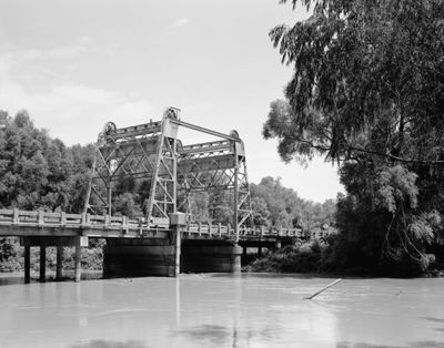
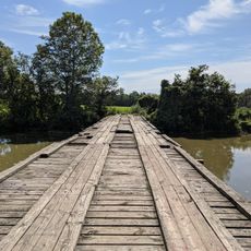
St. Francis River Bridge, Vertical-lift bridge in Lake City, Arkansas

St. Francis River Bridge is a vertical-lift bridge in Lake City, Arkansas, built with a special mechanism that allows the central section to raise and lower. The structure once carried road traffic across the water with a design typical of early 20th century engineering, featuring multiple steel spans.

It was built in 1934 by the Vincennes Bridge Company and served as a key transportation route until 1998. The structure represented the engineering approaches of its era for connecting rural areas separated by waterways.

It served as a vital link for communities on either side of the river and became part of the daily rhythm of local life. Crossing it connected people to jobs, markets, and family across the water in an era when such bridges were gateways between isolated areas.

The main lift structure is accessible from the east bank where you can see the original mechanism. A newer bridge was built beside it to handle modern traffic, so visitors can view the historic structure without interfering with road use.

It earned recognition on the National Register of Historic Places in 1990 as part of a statewide collection of historic bridges. This distinction marks it as a documented example of bridge engineering from the Depression era.

The community of curious travelers

AroundUs brings together thousands of curated places, local tips, and hidden gems, enriched daily by 60,000 contributors worldwide.

Start exploring
Location
GPS coordinates
35.82060,-90.43280
Latest update
December 14, 2025 18:00
Around this place
Farm No. 266—Johnny Cash Boyhood Home
United States of America

Farm No. 266—Johnny Cash Boyhood Home

30.1 km
Big Lake National Wildlife Refuge
United States of America

Big Lake National Wildlife Refuge

30.5 km
Paragould meteorite
United States of America

Paragould meteorite

21.2 km
George Ray's Dragstrip
United States of America

George Ray's Dragstrip

25.2 km
Herman Davis State Park
United States of America

Herman Davis State Park

24.8 km
Craighead County Courthouse
United States of America

Craighead County Courthouse

24.6 km
Bell House
United States of America

Bell House

24.8 km
Marked Tree Lock and Siphons
United States of America

Marked Tree Lock and Siphons

26.1 km
Berger House
United States of America

Berger House

24.6 km
Greene County Courthouse
United States of America

Greene County Courthouse

26.4 km
Mercantile Bank Building
United States of America

Mercantile Bank Building

24.7 km
National Bank of Commerce Building (Paragould, Arkansas)
United States of America

National Bank of Commerce Building (Paragould, Arkansas)

26.6 km
West Washington Avenue Historic District
United States of America

West Washington Avenue Historic District

25.1 km
Maxie Theatre
United States of America

Maxie Theatre

18.3 km
Craighead County Road 513C Bridge
United States of America

Craighead County Road 513C Bridge

11.1 km
Paragould War Memorial
United States of America

Paragould War Memorial

26.7 km
Linwood Mausoleum
United States of America

Linwood Mausoleum

26.4 km
Jackson-Herget House
United States of America

Jackson-Herget House

26.6 km
Judd Hill Cotton Gin
United States of America

Judd Hill Cotton Gin

25.4 km
Frierson House
United States of America

Frierson House

24.6 km
US Sen. Hattie Caraway Gravesite
United States of America

US Sen. Hattie Caraway Gravesite

27.7 km
Beisel-Mitchell House
United States of America

Beisel-Mitchell House

26.7 km
Highfill-McClure House
United States of America

Highfill-McClure House

27 km
Lepanto Commercial Historic District
United States of America

Lepanto Commercial Historic District

25.1 km
First National Bank Building
United States of America

First National Bank Building

11.4 km
Edward L. Westbrooke Building
United States of America

Edward L. Westbrooke Building

24.7 km
Johnny Cash Boyhood Home
United States of America

Johnny Cash Boyhood Home

30.1 km
Centennial Bank Stadium
United States of America

Centennial Bank Stadium

21.4 km
Show the full map
« St. Francis River Bridge - Vertical-lift bridge in Lake City, Arkansas » is provided by Around Us (aroundus.com). Images and texts are derived from Wikimedia project under a Creative Commons license. You are allowed to copy, distribute, and modify copies of this page, under the conditions set by the license, as long as this note is clearly visible.

Discover hidden gems everywhere you go!

From secret cafés to breathtaking viewpoints, skip the crowded tourist spots and find places that match your style. Our app makes it easy with voice search, smart filtering, route optimization, and insider tips from travelers worldwide. Download now for the complete mobile experience.

Around Us App Screenshot

A unique approach to discovering new places

Le Figaro

All the places worth exploring

France Info

A tailor-made excursion in just a few clicks

20 Minutes

Around Us
Travel Guide & Maps
Download

Send to your phone

QR Code
1

Open the camera app on your mobile.

2

Point at the QR code with your camera. A notification will appear.

3

Tap the notification to open the link.