Enable Location

We need your location to show you interesting places around you

Discover nearby places

Find interesting locations and hidden gems around you

Precise directions

Get accurate directions and distances to places

Your location is never shared with other users. It's only used when you tap the location button.

Marked Tree Lock and Siphons

Log in to your account

Start exploring — it's free

Trusted by 62,061 travelers worldwide

Continue with Google
Continue with Apple
or

We will send you a code to connect

By continuing, you accept our Terms and Conditions and our Privacy Policy

Check your inbox

We've sent a pincode in your inbox. Please enter the code below.

Marked Tree Lock and Siphons, Flood control facility in Poinsett County, United States

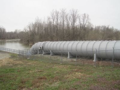
Marked Tree Lock and Siphons is a flood control facility in Poinsett County consisting of a concrete lock and three large steel tubes. The system uses a vacuum pump mechanism that draws water over an earthen levee and returns it directly to the river channel.

The facility was built in 1939 by the Memphis District Corps of Engineers to serve Drainage District Number Seven and protect the region from flooding. This project represented an important step in how communities managed water and defended themselves against seasonal river overflow.

The facility takes its name from the Marked Tree, a historic landmark that guided early settlers in the region. Today the place serves as a reminder of how engineering solutions shaped daily life for people living along the river.

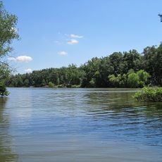
The facility sits along the St. Francis River on a levee and is accessible for visitors to view the engineering structures from different vantage points. Visiting in dry seasons makes it easier to observe how the system works and understand the overall layout.

The vacuum pump system operates without constant energy input by using natural pressure differences to move water over the levee. This clever approach was remarkably efficient for its time and requires only occasional maintenance to keep working properly.

The community of curious travelers

AroundUs brings together thousands of curated places, local tips, and hidden gems, enriched daily by 60,000 contributors worldwide.

Start exploring
Location
GPS coordinates
35.58610,-90.42970
Latest update
December 14, 2025 18:41
Around this place
Parkin Archeological State Park
United States of America

Parkin Archeological State Park

36.3 km
Farm No. 266—Johnny Cash Boyhood Home
United States of America

Farm No. 266—Johnny Cash Boyhood Home

16.8 km
Hampson Archeological Museum State Park
United States of America

Hampson Archeological Museum State Park

35.3 km
Lake Poinsett State Park
United States of America

Lake Poinsett State Park

24.1 km
L'Anguille River
United States of America

L'Anguille River

28 km
Craighead County Courthouse
United States of America

Craighead County Courthouse

37.4 km
Bell House
United States of America

Bell House

37.3 km
St. Francis River Bridge
United States of America

St. Francis River Bridge

26.1 km
Berger House
United States of America

Berger House

37 km
Berry Cemetery
United States of America

Berry Cemetery

32.3 km
Maxie Theatre
United States of America

Maxie Theatre

12.2 km
Poinsett County Courthouse
United States of America

Poinsett County Courthouse

26.2 km
Craighead County Road 513C Bridge
United States of America

Craighead County Road 513C Bridge

37.2 km
Tyronza Water Tower
United States of America

Tyronza Water Tower

12.5 km
Judd Hill Cotton Gin
United States of America

Judd Hill Cotton Gin

8.2 km
Frierson House
United States of America

Frierson House

37 km
Keiser Water Tower
United States of America

Keiser Water Tower

31.8 km
Keiser School
United States of America

Keiser School

31.8 km
Lepanto Commercial Historic District
United States of America

Lepanto Commercial Historic District

9.4 km
Wilson Residential Historic District
United States of America

Wilson Residential Historic District

35.9 km
Tyronza Methodist Episcopal Church, South
United States of America

Tyronza Methodist Episcopal Church, South

12.4 km
First National Bank Building
United States of America

First National Bank Building

34.9 km
Wilson Community House
United States of America

Wilson Community House

35.2 km
Old Turrell City Hall
United States of America

Old Turrell City Hall

28 km
Johnny Cash Boyhood Home
United States of America

Johnny Cash Boyhood Home

16.8 km
Wilson Commercial Historic District
United States of America

Wilson Commercial Historic District

35.1 km
Centennial Bank Stadium
United States of America

Centennial Bank Stadium

36.3 km
Monette Water Tower
United States of America

Monette Water Tower

35 km
Show the full map
« Marked Tree Lock and Siphons - Flood control facility in Poinsett County, United States » is provided by Around Us (aroundus.com). Images and texts are derived from Wikimedia project under a Creative Commons license. You are allowed to copy, distribute, and modify copies of this page, under the conditions set by the license, as long as this note is clearly visible.

Discover hidden gems everywhere you go!

From secret cafés to breathtaking viewpoints, skip the crowded tourist spots and find places that match your style. Our app makes it easy with voice search, smart filtering, route optimization, and insider tips from travelers worldwide. Download now for the complete mobile experience.

Around Us App Screenshot

A unique approach to discovering new places

Le Figaro

All the places worth exploring

France Info

A tailor-made excursion in just a few clicks

20 Minutes

Around Us
Travel Guide & Maps
Download

Send to your phone

QR Code
1

Open the camera app on your mobile.

2

Point at the QR code with your camera. A notification will appear.

3

Tap the notification to open the link.