Parkin Archeological State Park

Log in to your account

AroundUs is a community-driven map of interesting places, built by curious explorers like you. It grows with every review, story, and photo you share.
Connect to save your favorite spots, contribute locations, and create personalized routes.
By continuing, you accept our Terms and Conditions and our Privacy Policy
Add to collection
Map
Suggest a change
Share

Parkin Archeological State Park, Native American archaeological site in Parkin, Arkansas.

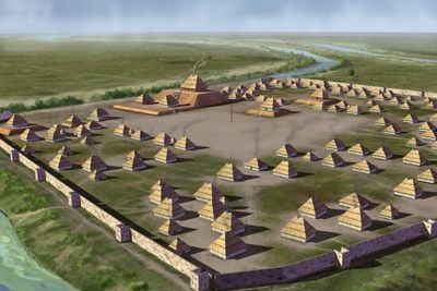
Parkin Archeological State Park is a 17-acre archaeological site along the St. Francis River featuring a central earthen mound and the remains of a palisaded village from the Mississippian Period. The grounds preserve the layout of houses and workspaces from this ancient settlement, with a visitor center offering exhibits and a working archaeological laboratory.

The settlement developed around 1000 CE as a major Mississippian center and continued through roughly 1550. Spanish explorers led by Hernando de Soto encountered this established community, recorded as Casqui in their accounts during their 1541 journey through the region.

The site represents a major center where Mississippian communities organized their daily lives and work around a central mound. Walking through the grounds, visitors can observe how buildings were positioned and what objects reveal about how people lived together.

The park features a visitor center with exhibits open Wednesday through Sunday for guided tours, and self-guided visits are available at no cost. A working archaeological laboratory at the center allows visitors to see how researchers examine and study artifacts discovered at the site.

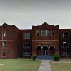
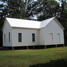
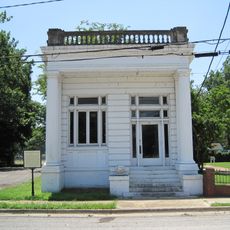
The Northern Ohio School, built in 1910, is the only surviving schoolhouse from that era in Parkin and served children of lumber mill workers. This building demonstrates how education became part of the community structure as the town developed alongside industrial activities.

Location: Arkansas

Website: https://arkansasstateparks.com/parks/parkin-archeological-state-park

GPS coordinates: 35.27714,-90.55741

Latest update: December 7, 2025 20:22

Photos
Around this place
Show the full map
Village Creek State Park
United States of America

Village Creek State Park

19.4 km
Lake Poinsett State Park
United States of America

Lake Poinsett State Park

30.8 km
Earle High School
United States of America

Earle High School

7.8 km
Marked Tree Lock and Siphons
United States of America

Marked Tree Lock and Siphons

36.3 km
Campbell House
United States of America

Campbell House

35.9 km
East Hamilton Avenue Historic District
United States of America

East Hamilton Avenue Historic District

24 km
Crittenden County Courthouse
United States of America

Crittenden County Courthouse

33.6 km
Berry Cemetery
United States of America

Berry Cemetery

8.5 km
St. Francis River Bridge
United States of America

St. Francis River Bridge

30.4 km
Poinsett County Courthouse
United States of America

Poinsett County Courthouse

35 km
First United Methodist Church
United States of America

First United Methodist Church

36.2 km
Hughes Water Tower
United States of America

Hughes Water Tower

37.3 km
Hamilton Apartments
United States of America

Hamilton Apartments

36.7 km
John H. Johnston Cotton Gin Historic District
United States of America

John H. Johnston Cotton Gin Historic District

14.5 km
Tyronza Water Tower
United States of America

Tyronza Water Tower

29.8 km
Judd Hill Cotton Gin
United States of America

Judd Hill Cotton Gin

36.5 km
New Hope School
United States of America

New Hope School

17.6 km
Lawrie House
United States of America

Lawrie House

37.3 km
West Memphis City Hall
United States of America

West Memphis City Hall

36.8 km
Marion Colored High School
United States of America

Marion Colored High School

33 km
Crittenden County Bank and Trust Company
United States of America

Crittenden County Bank and Trust Company

33.6 km
Johnson-Portis House
United States of America

Johnson-Portis House

36 km
Lepanto Commercial Historic District
United States of America

Lepanto Commercial Historic District

42.5 km
Tyronza Methodist Episcopal Church, South
United States of America

Tyronza Methodist Episcopal Church, South

29.7 km
Giboney-Robertson-Stewart House
United States of America

Giboney-Robertson-Stewart House

21.4 km
Wilson Power and Light Company Ice Plant
United States of America

Wilson Power and Light Company Ice Plant

37 km
Old Turrell City Hall
United States of America

Old Turrell City Hall

29.6 km
Wynne Wholesale Commercial Historic District
United States of America

Wynne Wholesale Commercial Historic District

22.3 km
Show the full map
Reviews

Visited this place? Tap the stars to rate it and share your experience / photos with the community! Try now! You can cancel it anytime.

« Parkin Archeological State Park - Native American archaeological site in Parkin, Arkansas » is provided by Around Us (aroundus.com). Images and texts are derived from Wikimedia project under a Creative Commons license. You are allowed to copy, distribute, and modify copies of this page, under the conditions set by the license, as long as this note is clearly visible.

Discover hidden gems everywhere you go!

From secret cafés to breathtaking viewpoints, skip the crowded tourist spots and find places that match your style. Our app makes it easy with voice search, smart filtering, route optimization, and insider tips from travelers worldwide. Download now for the complete mobile experience.

Around Us App Screenshot

A unique approach to discovering new places

Le Figaro

All the places worth exploring

France Info

A tailor-made excursion in just a few clicks

20 Minutes