Enable Location

We need your location to show you interesting places around you

Discover nearby places

Find interesting locations and hidden gems around you

Precise directions

Get accurate directions and distances to places

Your location is never shared with other users. It's only used when you tap the location button.

Earle High School

Log in to your account

Start exploring — it's free

Trusted by 62,806 travelers worldwide

Continue with Google
Continue with Apple
or

We will send you a code to connect

By continuing, you accept our Terms and Conditions and our Privacy Policy

Check your inbox

We've sent a pincode in your inbox. Please enter the code below.

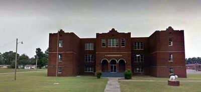
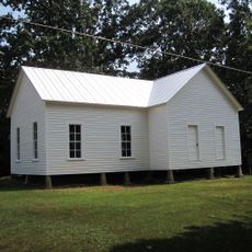
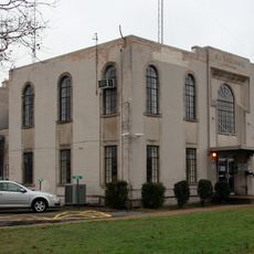
Earle High School, high school in Earle, Crittenden County, Arkansas

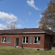
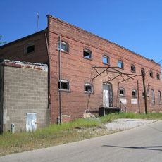
Earle High School is a red brick school building located in the town of Earle in Crittenden County, Arkansas. The structure features simple and sturdy construction with large windows and traditional school design from the early 20th century.

The school was established in 1909 and has served generations of students in the region. The older school building was used from 1919 until 1978 and was listed on the National Register of Historic Places in 2003.

The school displays red and white colors with the Bulldogs as its mascot, symbols that shape local identity in the town. These emblems connect students, teachers, and former graduates through shared traditions that remain part of the community's daily life.

The building is located in the town of Earle and is easy to spot as a distinctive red brick structure. Visitors can view the building from the outside and study its early 20th century architecture.

The school building survived a tornado that swept through the area in 2008 and continued to serve the community afterward. This resilience makes the structure a symbol of the town's endurance through hardship.

The community of curious travelers

AroundUs brings together thousands of curated places, local tips, and hidden gems, enriched daily by 60,000 contributors worldwide.

Start exploring
Location
Inception
1909
GPS coordinates
35.27111,-90.47139
Latest update
February 9, 2026 08:21
Around this place
Chucalissa Indian Village
United States of America

Chucalissa Indian Village

38.9 km
Parkin Archeological State Park
United States of America

Parkin Archeological State Park

7.8 km
Frisco Bridge
United States of America

Frisco Bridge

39.3 km
Meeman-Shelby Forest State Park
United States of America

Meeman-Shelby Forest State Park

38.2 km
T. O. Fuller State Park
United States of America

T. O. Fuller State Park

38.9 km
Village Creek State Park
United States of America

Village Creek State Park

25.5 km
Lake Poinsett State Park
United States of America

Lake Poinsett State Park

35.1 km
Marked Tree Lock and Siphons
United States of America

Marked Tree Lock and Siphons

35.3 km
East Hamilton Avenue Historic District
United States of America

East Hamilton Avenue Historic District

31.6 km
Crittenden County Courthouse
United States of America

Crittenden County Courthouse

25.8 km
Berry Cemetery
United States of America

Berry Cemetery

2.9 km
St. Francis River Bridge
United States of America

St. Francis River Bridge

34.2 km
Hughes Water Tower
United States of America

Hughes Water Tower

35.8 km
Hamilton Apartments
United States of America

Hamilton Apartments

29.3 km
John H. Johnston Cotton Gin Historic District
United States of America

John H. Johnston Cotton Gin Historic District

22.1 km
Tyronza Water Tower
United States of America

Tyronza Water Tower

26.5 km
Judd Hill Cotton Gin
United States of America

Judd Hill Cotton Gin

37.2 km
New Hope School
United States of America

New Hope School

24.7 km
Lawrie House
United States of America

Lawrie House

29.8 km
West Memphis City Hall
United States of America

West Memphis City Hall

29.5 km
Marion Colored High School
United States of America

Marion Colored High School

25.2 km
Crittenden County Bank and Trust Company
United States of America

Crittenden County Bank and Trust Company

25.9 km
Johnson-Portis House
United States of America

Johnson-Portis House

28.6 km
Tyronza Methodist Episcopal Church, South
United States of America

Tyronza Methodist Episcopal Church, South

26.4 km
Giboney-Robertson-Stewart House
United States of America

Giboney-Robertson-Stewart House

28.9 km
Wilson Power and Light Company Ice Plant
United States of America

Wilson Power and Light Company Ice Plant

29.6 km
Old Turrell City Hall
United States of America

Old Turrell City Hall

22.9 km
Wynne Wholesale Commercial Historic District
United States of America

Wynne Wholesale Commercial Historic District

29.8 km
Show the full map
« Earle High School - high school in Earle, Crittenden County, Arkansas » is provided by Around Us (aroundus.com). Images and texts are derived from Wikimedia project under a Creative Commons license. You are allowed to copy, distribute, and modify copies of this page, under the conditions set by the license, as long as this note is clearly visible.

Discover hidden gems everywhere you go!

From secret cafés to breathtaking viewpoints, skip the crowded tourist spots and find places that match your style. Our app makes it easy with voice search, smart filtering, route optimization, and insider tips from travelers worldwide. Download now for the complete mobile experience.

Around Us App Screenshot

A unique approach to discovering new places

Le Figaro

All the places worth exploring

France Info

A tailor-made excursion in just a few clicks

20 Minutes

Around Us
Travel Guide & Maps
Download

Send to your phone

QR Code
1

Open the camera app on your mobile.

2

Point at the QR code with your camera. A notification will appear.

3

Tap the notification to open the link.