Enable Location

We need your location to show you interesting places around you

Discover nearby places

Find interesting locations and hidden gems around you

Precise directions

Get accurate directions and distances to places

Your location is never shared with other users. It's only used when you tap the location button.

George Ray's Dragstrip

Log in to your account

Start exploring — it's free

Trusted by 62,818 travelers worldwide

Continue with Google
Continue with Apple
or

We will send you a code to connect

By continuing, you accept our Terms and Conditions and our Privacy Policy

Check your inbox

We've sent a pincode in your inbox. Please enter the code below.

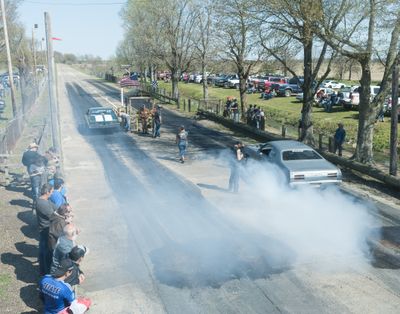
George Ray's Dragstrip, dragstrip in Greene County, Arkansas

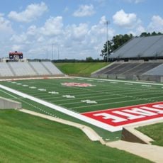
George Ray's Dragstrip is a racing facility in Greene County built in 1961 and designed exclusively for drag racing competitions. The track features a long, straight concrete surface with spectator seating alongside and a catwalk for officials running the length of the course.

The track was established in 1961 and represents one of Arkansas's oldest purpose-built racing venues dedicated solely to drag racing. Its inclusion on the National Register of Historic Places in 2006 recognized its importance as a historical site and legacy of the region's racing culture.

The dragstrip remains a gathering place where local car enthusiasts and racers connect with their shared passion for motorsport. Families and neighbors return repeatedly, treating it as a community space tied to memories and the region's racing heritage.

The site is located south of US 412 near Paragould and is easily accessible from Highway 135. Weekend races typically occur during favorable weather, so visitors should confirm event dates in advance and plan accordingly for viewing or participation.

A distinctive feature is the original catwalk system that has remained in place since George Ray's opening. This early infrastructure allowed officials and announcers to observe races clearly and represents a tangible link to the venue's foundational design.

The community of curious travelers

AroundUs brings together thousands of curated places, local tips, and hidden gems, enriched daily by 60,000 contributors worldwide.

Start exploring
Location
GPS coordinates
36.04722,-90.43444
Latest update
February 9, 2026 08:22
Around this place
Big Lake National Wildlife Refuge
United States of America

Big Lake National Wildlife Refuge

32.1 km
Crowley's Ridge State Park
United States of America

Crowley's Ridge State Park

20.7 km
Paragould meteorite
United States of America

Paragould meteorite

9.7 km
Lake Frierson State Park
United States of America

Lake Frierson State Park

26.7 km
Herman Davis State Park
United States of America

Herman Davis State Park

31 km
Craighead County Courthouse
United States of America

Craighead County Courthouse

33.8 km
Bell House
United States of America

Bell House

34.2 km
St. Francis River Bridge
United States of America

St. Francis River Bridge

25.2 km
Berger House
United States of America

Berger House

34.2 km
Greene County Courthouse
United States of America

Greene County Courthouse

4.8 km
Mercantile Bank Building
United States of America

Mercantile Bank Building

33.5 km
National Bank of Commerce Building (Paragould, Arkansas)
United States of America

National Bank of Commerce Building (Paragould, Arkansas)

4.8 km
West Washington Avenue Historic District
United States of America

West Washington Avenue Historic District

34 km
Craighead County Road 513C Bridge
United States of America

Craighead County Road 513C Bridge

14.2 km
Paragould War Memorial
United States of America

Paragould War Memorial

5 km
Linwood Mausoleum
United States of America

Linwood Mausoleum

6.2 km
Jackson-Herget House
United States of America

Jackson-Herget House

5.1 km
Frierson House
United States of America

Frierson House

34.2 km
Crowley's Ridge State Park-Comfort Station
United States of America

Crowley's Ridge State Park-Comfort Station

20.3 km
Crowley's Ridge State Park-Bathhouse
United States of America

Crowley's Ridge State Park-Bathhouse

20.7 km
Beisel-Mitchell House
United States of America

Beisel-Mitchell House

5.2 km
Highfill-McClure House
United States of America

Highfill-McClure House

5.5 km
Crowley's Ridge State Park-Dining Hall
United States of America

Crowley's Ridge State Park-Dining Hall

20.6 km
Crowley's Ridge State Park-Bridge
United States of America

Crowley's Ridge State Park-Bridge

20.6 km
Knob School
United States of America

Knob School

26.1 km
First National Bank Building
United States of America

First National Bank Building

19.2 km
Edward L. Westbrooke Building
United States of America

Edward L. Westbrooke Building

33.8 km
Centennial Bank Stadium
United States of America

Centennial Bank Stadium

30.5 km
Show the full map
« George Ray's Dragstrip - dragstrip in Greene County, Arkansas » is provided by Around Us (aroundus.com). Images and texts are derived from Wikimedia project under a Creative Commons license. You are allowed to copy, distribute, and modify copies of this page, under the conditions set by the license, as long as this note is clearly visible.

Discover hidden gems everywhere you go!

From secret cafés to breathtaking viewpoints, skip the crowded tourist spots and find places that match your style. Our app makes it easy with voice search, smart filtering, route optimization, and insider tips from travelers worldwide. Download now for the complete mobile experience.

Around Us App Screenshot

A unique approach to discovering new places

Le Figaro

All the places worth exploring

France Info

A tailor-made excursion in just a few clicks

20 Minutes

Around Us
Travel Guide & Maps
Download

Send to your phone

QR Code
1

Open the camera app on your mobile.

2

Point at the QR code with your camera. A notification will appear.

3

Tap the notification to open the link.