Lower North Philadelphia Speculative Housing Historic District

Log in to your account

AroundUs is a community-driven map of interesting places, built by curious explorers like you. It grows with every review, story, and photo you share.
Connect to save your favorite spots, contribute locations, and create personalized routes.
By continuing, you accept our Terms and Conditions and our Privacy Policy

Lower North Philadelphia Speculative Housing Historic District

Add to collection
Map
Suggest a change
Share

Lower North Philadelphia Speculative Housing Historic District, Historic district in North Philadelphia, Pennsylvania.

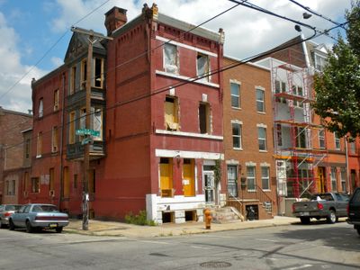
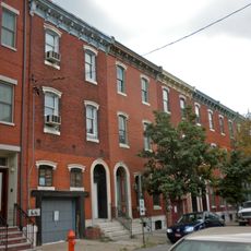
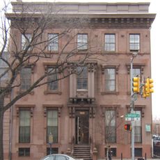
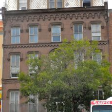
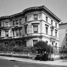
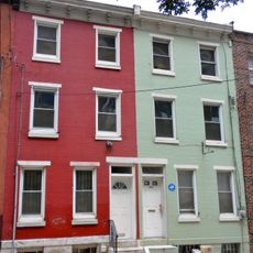
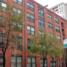
The Lower North Philadelphia Speculative Housing Historic District encompasses approximately 60 acres of predominantly three-story rowhouses built between 1868 and 1875, featuring Italianate and Gothic architectural styles designed by architects including Willis Hale and Thomas Lonsdate.

This district was developed during Philadelphia's rapid urban expansion in the late 19th century to accommodate the city's growing population, particularly immigrant communities seeking affordable housing options outside the city center through speculative construction practices.

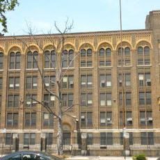
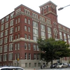
The district includes several religious establishments such as the former Gethsemane Baptist Church, Messiah Lutheran Church, and the Universalist Church of the Restoration, along with educational institutions like the George Meade School and Wagner Free Institute of Science.

Listed on the National Register of Historic Places on March 12, 1999, under reference number 99000325, the district is accessible via public transit and offers walking tours organized by local community groups focusing on its architectural significance.

The district represents one of the most cohesive examples of 19th-century speculative housing development in Philadelphia, where developers constructed uniform rowhouses with 14 to 21-foot widths specifically designed for quick sale and profit rather than architectural distinction.

Location: Pennsylvania

GPS coordinates: 39.96670,-75.16220

Latest update: July 24, 2025 11:36

Photos
Around this place
Show the full map
Eastern State Penitentiary
United States of America

Eastern State Penitentiary

897 m
The Met Philadelphia
United States of America

The Met Philadelphia

422 m
Philadelphia Pennsylvania Temple
United States of America

Philadelphia Pennsylvania Temple

1 km
Inquirer Building
United States of America

Inquirer Building

661 m
Congregation Rodeph Shalom
United States of America

Congregation Rodeph Shalom

338 m
Packard Motor Corporation Building
United States of America

Packard Motor Corporation Building

902 m
Church of the Gesú
United States of America

Church of the Gesú

813 m
Parkway Central Library
United States of America

Parkway Central Library

1.1 km
Cathedral of the Immaculate Conception
United States of America

Cathedral of the Immaculate Conception

1 km
Bergdoll Mansion
United States of America

Bergdoll Mansion

1.1 km
Fairmount Avenue Historic District
United States of America

Fairmount Avenue Historic District

0 m
Thaddeus Stevens School of Observation
United States of America

Thaddeus Stevens School of Observation

533 m
Edwin Forrest House
United States of America

Edwin Forrest House

753 m
Thomas Eakins House
United States of America

Thomas Eakins House

447 m
Terminal Commerce Building
United States of America

Terminal Commerce Building

990 m
Spring Garden School No. 1
United States of America

Spring Garden School No. 1

550 m
Reading Company Grain Elevator
United States of America

Reading Company Grain Elevator

1 km
Matthew Baird Mansion
United States of America

Matthew Baird Mansion

959 m
Pennsylvania State Office Building
United States of America

Pennsylvania State Office Building

523 m
Callowhill Industrial Historic District
United States of America

Callowhill Industrial Historic District

780 m
North Broad Street Mansion District
United States of America

North Broad Street Mansion District

1.1 km
Girard Avenue Historic District
United States of America

Girard Avenue Historic District

672 m
Philadelphia Wholesale Drug Company Building
United States of America

Philadelphia Wholesale Drug Company Building

804 m
Mulford Building
United States of America

Mulford Building

1 km
Graham and Laird, Schober and Mitchell Factories
United States of America

Graham and Laird, Schober and Mitchell Factories

813 m
Harrington Machine Shop
United States of America

Harrington Machine Shop

789 m
Smaltz Building
United States of America

Smaltz Building

847 m
Snellenburg's Clothing Factory
United States of America

Snellenburg's Clothing Factory

173 m
Show the full map
Reviews

Visited this place? Tap the stars to rate it and share your experience / photos with the community! Try now! You can cancel it anytime.

« Lower North Philadelphia Speculative Housing Historic District - Historic district in North Philadelphia, Pennsylvania » is provided by Around Us (aroundus.com). Images and texts are derived from Wikimedia project under a Creative Commons license. You are allowed to copy, distribute, and modify copies of this page, under the conditions set by the license, as long as this note is clearly visible.

Discover hidden gems everywhere you go!

From secret cafés to breathtaking viewpoints, skip the crowded tourist spots and find places that match your style. Our app makes it easy with voice search, smart filtering, route optimization, and insider tips from travelers worldwide. Download now for the complete mobile experience.

Around Us App Screenshot

A unique approach to discovering new places

Le Figaro

All the places worth exploring

France Info

A tailor-made excursion in just a few clicks

20 Minutes