Enable Location

We need your location to show you interesting places around you

Discover nearby places

Find interesting locations and hidden gems around you

Precise directions

Get accurate directions and distances to places

Your location is never shared with other users. It's only used when you tap the location button.

Manning Manse

Log in to your account

Start exploring — it's free

Trusted by 61,937 travelers worldwide

Continue with Google
Continue with Apple
or

We will send you a code to connect

By continuing, you accept our Terms and Conditions and our Privacy Policy

Check your inbox

We've sent a pincode in your inbox. Please enter the code below.

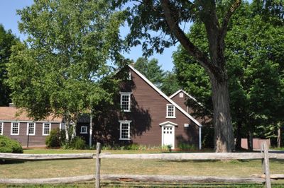
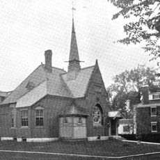
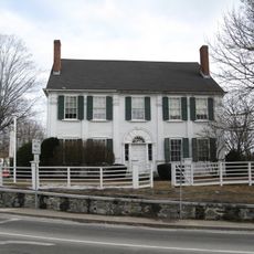
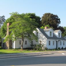
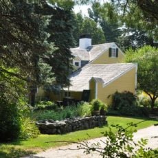
Manning Manse, Historic building in North Billerica, Massachusetts, United States.

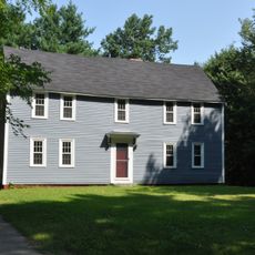
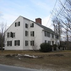
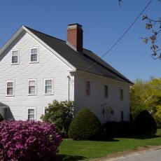
Manning Manse is a wooden-frame house with a gabled roof, central chimney, and clapboard siding situated on four acres of property. The structure displays classic elements of early American residential design with traditional building methods throughout.

Samuel Manning built this house in 1696, making it one of only two buildings from that era still standing in the Billerica area. The structure survived over three centuries of changes and remained a witness to the region's early settlement.

The house served the community for generations as a gathering place where people came together over food and drink. Walking through it today, you can sense how it was woven into the rhythm of local life.

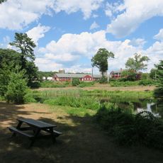
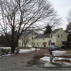
The building sits on Chelmsford Road and currently operates as a restaurant, so visitors can experience it while dining or stopping by. The adjacent state forest on three sides makes the location easy to find and offers a pleasant surrounding environment.

A major fire caused extensive damage to the structure, but careful restoration brought it back to life while keeping its historical character intact. The work revealed how dedicated people were to preserving what the building once was.

The community of curious travelers

AroundUs brings together thousands of curated places, local tips, and hidden gems, enriched daily by 60,000 contributors worldwide.

Start exploring
Location
GPS coordinates
42.58417,-71.30194
Latest update
December 14, 2025 09:47
Around this place
Lowell National Historical Park
United States of America

Lowell National Historical Park

6 km
Middlesex Canal
United States of America

Middlesex Canal

1.7 km
Cross Point Lowell
United States of America

Cross Point Lowell

3.9 km
Great Brook Farm State Park
United States of America

Great Brook Farm State Park

5.3 km
Lowell Cemetery
United States of America

Lowell Cemetery

5 km
Cawley Memorial Stadium
United States of America

Cawley Memorial Stadium

5.9 km
Edson Cemetery
United States of America

Edson Cemetery

3.6 km
Chelmsford Forum
United States of America

Chelmsford Forum

705 m
Shedd Park
United States of America

Shedd Park

5.3 km
Billerica Mills Historic District
United States of America

Billerica Mills Historic District

1.5 km
Belvidere Hill Historic District
United States of America

Belvidere Hill Historic District

6 km
Billerica Public Library
United States of America

Billerica Public Library

3.9 km
Howe School
United States of America

Howe School

3.6 km
Fiske House
United States of America

Fiske House

4.3 km
Colburn School
United States of America

Colburn School

6.2 km
Rogers Fort Hill Park Historic District
United States of America

Rogers Fort Hill Park Historic District

5.7 km
Chelmsford Center Historic District
United States of America

Chelmsford Center Historic District

4.6 km
Wamesit Canal-Whipple Mill Industrial Complex
United States of America

Wamesit Canal-Whipple Mill Industrial Complex

5.4 km
Sabbath Day House
United States of America

Sabbath Day House

3.8 km
Deacon Samuel Hill House
United States of America

Deacon Samuel Hill House

5.4 km
Zeb Spaulding House
United States of America

Zeb Spaulding House

5.2 km
Barrett-Byam Homestead
United States of America

Barrett-Byam Homestead

5.6 km
Dutton-Holden Homestead
United States of America

Dutton-Holden Homestead

3.7 km
South Common Historic District
United States of America

South Common Historic District

5.9 km
Tyler Park Historic District
United States of America

Tyler Park Historic District

6.1 km
Wilder Street Historic District
United States of America

Wilder Street Historic District

6.3 km
George Robbins House
United States of America

George Robbins House

5.3 km
Portuguese Colonial Wars and Carnation Revolution memorial
United States of America

Portuguese Colonial Wars and Carnation Revolution memorial

6.2 km
Show the full map
« Manning Manse - Historic building in North Billerica, Massachusetts, United States » is provided by Around Us (aroundus.com). Images and texts are derived from Wikimedia project under a Creative Commons license. You are allowed to copy, distribute, and modify copies of this page, under the conditions set by the license, as long as this note is clearly visible.

Discover hidden gems everywhere you go!

From secret cafés to breathtaking viewpoints, skip the crowded tourist spots and find places that match your style. Our app makes it easy with voice search, smart filtering, route optimization, and insider tips from travelers worldwide. Download now for the complete mobile experience.

Around Us App Screenshot

A unique approach to discovering new places

Le Figaro

All the places worth exploring

France Info

A tailor-made excursion in just a few clicks

20 Minutes

Around Us
Travel Guide & Maps
Download

Send to your phone

QR Code
1

Open the camera app on your mobile.

2

Point at the QR code with your camera. A notification will appear.

3

Tap the notification to open the link.