Enable Location

We need your location to show you interesting places around you

Discover nearby places

Find interesting locations and hidden gems around you

Precise directions

Get accurate directions and distances to places

Your location is never shared with other users. It's only used when you tap the location button.

Main Street Historic District

Log in to your account

Start exploring — it's free

Trusted by 62,376 travelers worldwide

Continue with Google
Continue with Apple
or

We will send you a code to connect

By continuing, you accept our Terms and Conditions and our Privacy Policy

Check your inbox

We've sent a pincode in your inbox. Please enter the code below.

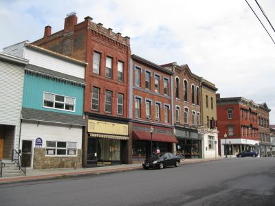
Main Street Historic District, historic district in Whitehall, New York, United States

Main Street Historic District is a historic district in New York that spans roughly two streets and contains about forty buildings made primarily of brick and stone. Most structures are two to three stories tall and served as shops or businesses, many facing the nearby Champlain Canal.

The district was rebuilt after a major fire in 1864 that destroyed many earlier structures. Most buildings were constructed between 1865 and 1900 during a period of growth and renewal, with many designed by local architect Almon Chandler Hopson.

The district reflects the importance of commerce and waterway transportation in shaping the region's growth. The buildings show how this area served as a center for business and community life.

The district is easy to explore on foot since important sites are located close together. There are signs and information available on site to help you understand the history of each building.

The place became an architectural testament to community rebuilding and resilience after a devastating 1864 fire. This disaster led to a unified and cohesive design of buildings that gives the district its distinctive appearance to this day.

The community of curious travelers

AroundUs brings together thousands of curated places, local tips, and hidden gems, enriched daily by 60,000 contributors worldwide.

Start exploring
Location
GPS coordinates
43.55611,-73.40194
Latest update
February 9, 2026 07:40
Around this place
Champlain Canal
United States of America

Champlain Canal

13.2 km
Skene Manor
United States of America

Skene Manor

204 m
Owl's Nest
United States of America

Owl's Nest

23.9 km
Castleton Medical College Building
United States of America

Castleton Medical College Building

19 km
William Miller Chapel and Ascension Rock
United States of America

William Miller Chapel and Ascension Rock

8.4 km
Half Moon Pond State Park
United States of America

Half Moon Pond State Park

21.5 km
Wilgus State Park
United States of America

Wilgus State Park

18 km
Lemuel Haynes House
United States of America

Lemuel Haynes House

22.7 km
South Granville Congregational Church
United States of America

South Granville Congregational Church

22.5 km
Fort Warren
United States of America

Fort Warren

20.1 km
Old Stone House Library
United States of America

Old Stone House Library

17.5 km
Elisha Straight House
United States of America

Elisha Straight House

21.7 km
South Street Bridge
United States of America

South Street Bridge

14.4 km
West Haven Baptist Church
United States of America

West Haven Baptist Church

11.4 km
Dayton-Williams House
United States of America

Dayton-Williams House

16.6 km
Home Farm
United States of America

Home Farm

6.3 km
South Granville Congregational Church and Parsonage
United States of America

South Granville Congregational Church and Parsonage

22.5 km
Asahel Kidder House
United States of America

Asahel Kidder House

11.3 km
Fair Haven Green Historic District
United States of America

Fair Haven Green Historic District

11.7 km
Pember Library and Museum
United States of America

Pember Library and Museum

20.1 km
Hydeville School
United States of America

Hydeville School

14.9 km
East Poultney Historic District
United States of America

East Poultney Historic District

16.1 km
Simeon Smith House
United States of America

Simeon Smith House

12.1 km
Hiram Congdon House
United States of America

Hiram Congdon House

16.1 km
Braintree School
United States of America

Braintree School

24.8 km
Poultney Main Street Historic District
United States of America

Poultney Main Street Historic District

14.2 km
Middletown Springs Historic District
United States of America

Middletown Springs Historic District

24.2 km
William Miller Home
United States of America

William Miller Home

8.6 km
Show the full map
« Main Street Historic District - historic district in Whitehall, New York, United States » is provided by Around Us (aroundus.com). Images and texts are derived from Wikimedia project under a Creative Commons license. You are allowed to copy, distribute, and modify copies of this page, under the conditions set by the license, as long as this note is clearly visible.

Discover hidden gems everywhere you go!

From secret cafés to breathtaking viewpoints, skip the crowded tourist spots and find places that match your style. Our app makes it easy with voice search, smart filtering, route optimization, and insider tips from travelers worldwide. Download now for the complete mobile experience.

Around Us App Screenshot

A unique approach to discovering new places

Le Figaro

All the places worth exploring

France Info

A tailor-made excursion in just a few clicks

20 Minutes

Around Us
Travel Guide & Maps
Download

Send to your phone

QR Code
1

Open the camera app on your mobile.

2

Point at the QR code with your camera. A notification will appear.

3

Tap the notification to open the link.