Enable Location

We need your location to show you interesting places around you

Discover nearby places

Find interesting locations and hidden gems around you

Precise directions

Get accurate directions and distances to places

Your location is never shared with other users. It's only used when you tap the location button.

Meramec Caverns

Log in to your account

Start exploring — it's free

Trusted by 61,906 travelers worldwide

Continue with Google
Continue with Apple
or

We will send you a code to connect

By continuing, you accept our Terms and Conditions and our Privacy Policy

Check your inbox

We've sent a pincode in your inbox. Please enter the code below.

Meramec Caverns

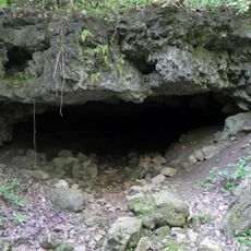
Meramec Caverns, Show cave in Ozarks, Missouri, United States.

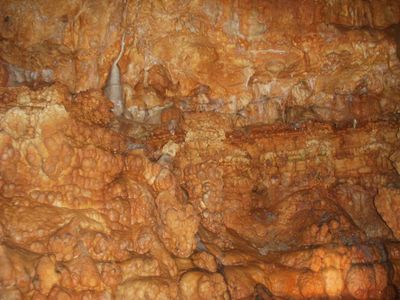
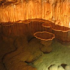
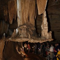
Meramec Caverns is a show cave system along the Meramec River in eastern Missouri with passages that extend through multiple levels and are made accessible through electric lighting. The site includes rooms with limestone deposits that have taken various forms and are explored through guided routes.

Local groups used the caverns as shelter before French explorers mapped them in the early eighteenth century. Later the passages served for saltpeter mining during the Civil War and were developed as a commercial attraction starting in the 1930s.

The ballroom inside takes its name from square dances held there starting in 1890. Musicians still use the room for concerts because the limestone carries sound naturally.

Guided tours follow paved walkways that maintain a temperature near 60 degrees Fahrenheit (15 Celsius) throughout the year. The routes require no special gear and suit visitors with regular walking ability.

The largest chamber is named Stage Curtain because of a limestone wall that looks like a folded drape. This effect formed through water flowing along the same lines for thousands of years.

The community of curious travelers

AroundUs brings together thousands of curated places, local tips, and hidden gems, enriched daily by 60,000 contributors worldwide.

Start exploring
Location
GPS coordinates
38.24127,-91.09237
Latest update
December 20, 2025 03:04
Natural wonders and historic sites of Missouri

Missouri offers a mix of geological formations and historic sites that show the natural resources and industrial past of the state. The landscape includes massive granite boulders, deep limestone caves, and clear springs that bubble up from the ground. Parks and conservation areas preserve forests,...

Around this place
Onondaga Cave State Park
United States of America

Onondaga Cave State Park

23.6 km
Meramec State Park
United States of America

Meramec State Park

4 km
International Shoe Company Building
United States of America

International Shoe Company Building

15.4 km
United States of America

Maj. Gen. William S. Harney Summer Home

7.5 km
Meramec Conservation Area
United States of America

Meramec Conservation Area

2.2 km
United States of America

Moselle Iron Furnace Stack

24.1 km
United States of America

Blue Springs Creek Conservation Area

15.6 km
United States of America

Scotia Iron Furnace Stack

24.4 km
United States of America

Christian and Anna Keller Farmstead

28.9 km
Panhorst Feed Store
United States of America

Panhorst Feed Store

15.2 km
United States of America

Christopher and Johanna Twelker Farm

29.7 km
United States of America

Old Gerald School

27.6 km
United States of America

James North House

30 km
Jesse James Wax Museum
United States of America

Jesse James Wax Museum

3.7 km
United States of America

Meramec State Park Lookout House/Observation Tower

3.2 km
United States of America

Meramec State Park Shelter House

3 km
United States of America

Meramec State Park Pump House

4 km
United States of America

Meramec State Park Beach Area Historic District

3.8 km
United States of America

Meramec Caverns

33 m
United States of America

Meramec Lakes Golf Course

17.8 km
United States of America

Old Bus Stop and Gallery Route 66

15.6 km
United States of America

Franklin County Country Club

29.6 km
United States of America

Meremec Caverns

27 m
United States of America

Benjamin Franklin

23.9 km
United States of America

Scenic viewpoint

16.2 km
United States of America

Scenic viewpoint

16.2 km
United States of America

Scenic viewpoint

4.7 km
United States of America

Waterfall

22.4 km
Show the full map
« Meramec Caverns - Show cave in Ozarks, Missouri, United States » is provided by Around Us (aroundus.com). Images and texts are derived from Wikimedia project under a Creative Commons license. You are allowed to copy, distribute, and modify copies of this page, under the conditions set by the license, as long as this note is clearly visible.

Discover hidden gems everywhere you go!

From secret cafés to breathtaking viewpoints, skip the crowded tourist spots and find places that match your style. Our app makes it easy with voice search, smart filtering, route optimization, and insider tips from travelers worldwide. Download now for the complete mobile experience.

Around Us App Screenshot

A unique approach to discovering new places

Le Figaro

All the places worth exploring

France Info

A tailor-made excursion in just a few clicks

20 Minutes

Around Us
Travel Guide & Maps
Download

Send to your phone

QR Code
1

Open the camera app on your mobile.

2

Point at the QR code with your camera. A notification will appear.

3

Tap the notification to open the link.