Enable Location

We need your location to show you interesting places around you

Discover nearby places

Find interesting locations and hidden gems around you

Precise directions

Get accurate directions and distances to places

Your location is never shared with other users. It's only used when you tap the location button.

Meramec Conservation Area

Log in to your account

Start exploring — it's free

Trusted by 61,324 travelers worldwide

Continue with Google
Continue with Apple
or

We will send you a code to connect

By continuing, you accept our Terms and Conditions and our Privacy Policy

Check your inbox

We've sent a pincode in your inbox. Please enter the code below.

Meramec Conservation Area

Meramec Conservation Area, Conservation area near Sullivan, Missouri

Description

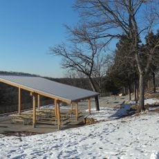
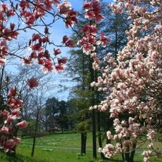
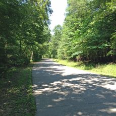
Meramec Conservation Area is a protected forest in Franklin County featuring wooded hills, limestone caves, and riparian habitat along the Meramec River. The site contains a variety of trails ranging from easy walks through the woods to longer routes suitable for hiking, biking, and horseback riding.

History

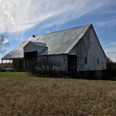
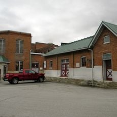
Missouri acquired most of the land between 1925 and 1930, establishing it as a public conservation space during the Depression. The Civilian Conservation Corps developed trails and facilities throughout the 1930s to make the forest accessible to visitors.

Culture

The site houses artifacts and structures from the Civilian Conservation Corps, which built much of what visitors see today during the Depression era. These remnants tell the story of how young workers shaped the land into a public resource.

Practical

The area has trails for different activities, from short woodland walks to longer routes for hikers, bikers, and riders. Visitors should check conditions before arriving since some sections may be closed for maintenance or due to seasonal weather.

Did you know?

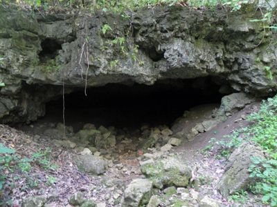
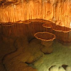
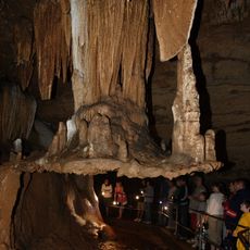
The site contains six caves that remain closed to visitors to protect bats from a fungal disease spread through cave exploration. This conservation measure protects an underground ecosystem while allowing the forest above to stay open for public use.

Location
GPS coordinates
38.23070,-91.07100
Latest update
December 14, 2025 18:43

AroundUs brings together thousands of curated places, local tips, and hidden gems, enriched daily by 60,000 contributors worldwide. Discover all places nearby (Franklin County).

Around this place
Meramec Caverns
United States of America

Meramec Caverns

2.2 km
Onondaga Cave State Park
United States of America

Onondaga Cave State Park

23.6 km
Meramec State Park
United States of America

Meramec State Park

3.8 km
Don Robinson State Park
United States of America

Don Robinson State Park

36.7 km
Shaw Nature Reserve
United States of America

Shaw Nature Reserve

35.3 km
Robertsville State Park
United States of America

Robertsville State Park

31 km
Wilhelm Pelster House-Barn
United States of America

Wilhelm Pelster House-Barn

34.1 km
John B. Busch Brewery Historic District
United States of America

John B. Busch Brewery Historic District

36.2 km
Henry and Elizabeth Ernst House
United States of America

Henry and Elizabeth Ernst House

36.1 km
George B. Hamilton House
United States of America

George B. Hamilton House

34.4 km
Hotel Cuba
United States of America

Hotel Cuba

35.4 km
Cuba City Jail
United States of America

Cuba City Jail

34.8 km
Panhorst Feed Store
United States of America

Panhorst Feed Store

15.1 km
Cuba High School Annex
United States of America

Cuba High School Annex

34.9 km
John Manson Munro House
United States of America

John Manson Munro House

34.8 km
Mark O'Hara House
United States of America

Mark O'Hara House

35.8 km
Dr. H. A. May House
United States of America

Dr. H. A. May House

36.6 km
Uptown Cuba Historic District
United States of America

Uptown Cuba Historic District

34.9 km
John Meyer House
United States of America

John Meyer House

36.2 km
Cuba Lodge No. 312 A.F. and A.M.
United States of America

Cuba Lodge No. 312 A.F. and A.M.

34.9 km
Bartsch-Jasper House
United States of America

Bartsch-Jasper House

35.4 km
Henry Beins House
United States of America

Henry Beins House

36.3 km
Henry F. Beinke House
United States of America

Henry F. Beinke House

36.5 km
Henry Bartelmann House
United States of America

Henry Bartelmann House

36.5 km
John H. Broeker House
United States of America

John H. Broeker House

36.4 km
Paul Monje House
United States of America

Paul Monje House

36.5 km
Jesse James Wax Museum
United States of America

Jesse James Wax Museum

5.6 km
Wildey Cemetery
United States of America

Wildey Cemetery

35.5 km
Show the full map
« Meramec Conservation Area - Conservation area near Sullivan, Missouri » is provided by Around Us (aroundus.com). Images and texts are derived from Wikimedia project under a Creative Commons license. You are allowed to copy, distribute, and modify copies of this page, under the conditions set by the license, as long as this note is clearly visible.

Discover hidden gems everywhere you go!

From secret cafés to breathtaking viewpoints, skip the crowded tourist spots and find places that match your style. Our app makes it easy with voice search, smart filtering, route optimization, and insider tips from travelers worldwide. Download now for the complete mobile experience.

Around Us App Screenshot

A unique approach to discovering new places

Le Figaro

All the places worth exploring

France Info

A tailor-made excursion in just a few clicks

20 Minutes

Around Us
Travel Guide & Maps
Download

Send to your phone

QR Code
1

Open the camera app on your mobile.

2

Point at the QR code with your camera. A notification will appear.

3

Tap the notification to open the link.