Enable Location

We need your location to show you interesting places around you

Discover nearby places

Find interesting locations and hidden gems around you

Precise directions

Get accurate directions and distances to places

Your location is never shared with other users. It's only used when you tap the location button.

Meramec State Park

Log in to your account

Start exploring — it's free

Trusted by 65,531 travelers worldwide

Continue with Google
Continue with Apple
or

We will send you a code to connect

By continuing, you accept our Terms and Conditions and our Privacy Policy

Check your inbox

We've sent a pincode in your inbox. Please enter the code below.

Meramec State Park
Discussion Reviews 1 Photos
5.7k Popularity

Meramec State Park, State park and cave system in Sullivan, Missouri.

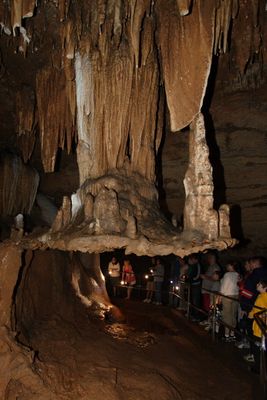
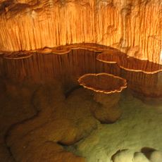
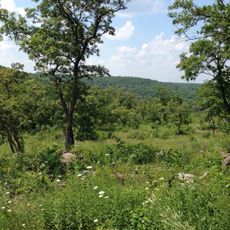
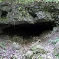
Meramec State Park is a natural area in Missouri with limestone formations, dense forests, and five developed caves running along the Meramec River. The park covers a large stretch of land with exposed rock outcrops and an underground cave network that reaches across three counties.

Missouri set this land aside as a protected park in 1927, partly to preserve cave systems that indigenous peoples and early settlers had used for shelter over many generations. The decision came at a time when the state began to recognize the value of protecting natural landscapes from development.

The name Meramec comes from a Native American language and refers to the catfish that populate the river. Walking along the riverbank, visitors can see the fish-rich water and understand why that name has stayed attached to this place for so long.

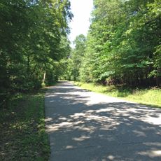
Fisher Cave can be visited on a guided tour, where lighting and safety equipment are provided, making it accessible even for those without caving experience. For those who prefer the outdoors, the park has over 13 miles (about 21 km) of hiking trails through forest and along the river.

The underground passages of the park run beneath three separate counties, which is rare for a single park property. This is easy to miss when walking the surface trails, yet the limestone beneath your feet connects landscapes that are administratively separated above ground.

The community of curious travelers

AroundUs brings together thousands of curated places, local tips, and hidden gems, enriched daily by 60,000 contributors worldwide.

Start exploring
Location
Location
Inception
1927
GPS coordinates
38.20667,-91.10250
Latest update
March 3, 2026 10:08
Around this place
Meramec Caverns
United States of America

Meramec Caverns

4 km
Onondaga Cave State Park
United States of America

Onondaga Cave State Park

19.9 km
Washington State Park
United States of America

Washington State Park

39.1 km
Shaw Nature Reserve
United States of America

Shaw Nature Reserve

39.1 km
Robertsville State Park
United States of America

Robertsville State Park

34.9 km
Meramec Conservation Area
United States of America

Meramec Conservation Area

3.8 km
Wilhelm Pelster House-Barn
United States of America

Wilhelm Pelster House-Barn

35.2 km
John B. Busch Brewery Historic District
United States of America

John B. Busch Brewery Historic District

39.3 km
Henry and Elizabeth Ernst House
United States of America

Henry and Elizabeth Ernst House

39.2 km
George B. Hamilton House
United States of America

George B. Hamilton House

30.6 km
Hotel Cuba
United States of America

Hotel Cuba

31.7 km
Cuba City Jail
United States of America

Cuba City Jail

31 km
Panhorst Feed Store
United States of America

Panhorst Feed Store

18.8 km
Cuba High School Annex
United States of America

Cuba High School Annex

31.2 km
John Manson Munro House
United States of America

John Manson Munro House

31 km
Mark O'Hara House
United States of America

Mark O'Hara House

39.1 km
Dr. H. A. May House
United States of America

Dr. H. A. May House

39.8 km
Uptown Cuba Historic District
United States of America

Uptown Cuba Historic District

31.2 km
John Meyer House
United States of America

John Meyer House

39.4 km
Cuba Lodge No. 312 A.F. and A.M.
United States of America

Cuba Lodge No. 312 A.F. and A.M.

31.1 km
Bartsch-Jasper House
United States of America

Bartsch-Jasper House

38.4 km
Henry Beins House
United States of America

Henry Beins House

39.4 km
Henry F. Beinke House
United States of America

Henry F. Beinke House

39.6 km
Henry Bartelmann House
United States of America

Henry Bartelmann House

39.6 km
John H. Broeker House
United States of America

John H. Broeker House

39.5 km
Paul Monje House
United States of America

Paul Monje House

39.5 km
Jesse James Wax Museum
United States of America

Jesse James Wax Museum

7.4 km
Wildey Cemetery
United States of America

Wildey Cemetery

38.5 km
Show the full map
Reviews
Share your experience

No review yet

Discussions
Start a discussion...

No discussion yet

« Meramec State Park - State park and cave system in Sullivan, Missouri » is provided by Around Us (aroundus.com). Images and texts are derived from Wikimedia project under a Creative Commons license. You are allowed to copy, distribute, and modify copies of this page, under the conditions set by the license, as long as this note is clearly visible.

Discover hidden gems everywhere you go!

From secret cafés to breathtaking viewpoints, skip the crowded tourist spots and find places that match your style. Our app makes it easy with voice search, smart filtering, route optimization, and insider tips from travelers worldwide. Download now for the complete mobile experience.

Around Us App Screenshot

A unique approach to discovering new places

Le Figaro

All the places worth exploring

France Info

A tailor-made excursion in just a few clicks

20 Minutes

Around Us
Travel Guide & Maps
Download

Send to your phone

QR Code
1

Open the camera app on your mobile.

2

Point at the QR code with your camera. A notification will appear.

3

Tap the notification to open the link.