See the monuments around you in AROpen chests in the app
Around Us is built for your phone — point your camera at the streets and discover the monuments and places around you in augmented reality.Around Us is built for your phone — chests unlock when you walk, explore and capture nearby places.
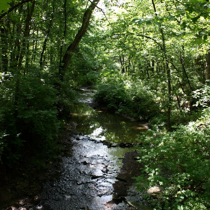
Missouri offers a mix of geological formations and historic sites that show the natural resources and industrial past of the state. The landscape includes massive granite boulders, deep limestone caves, and clear springs that bubble up from the ground. Parks and conservation areas preserve forests, creeks, and bluffs along the state's rivers. Visitors find hiking trails that wind through wooded hills, along stream beds, and to viewpoints that overlook broad valleys.
Historic sites add layers of human history. Stone mills like Bollinger Mill and Alley Mill still stand, their waterwheels and timber structures recalling a time when grinding grain and making textiles happened locally. Ha Ha Tonka State Park displays the ruins of a stone castle perched on a bluff above a lake, while Watkins Woolen Mill contains a preserved 19th-century textile factory. Caves such as Onondaga Cave and Meramec Caverns open beneath the surface, revealing stalactites, stalagmites, and underground rivers. Elephant Rocks State Park shows giant pink granite boulders scattered across hillsides, and Dogwood Canyon Nature Park offers waterfalls and forest trails. These places provide a look at Missouri's natural geology and the communities that once used it.
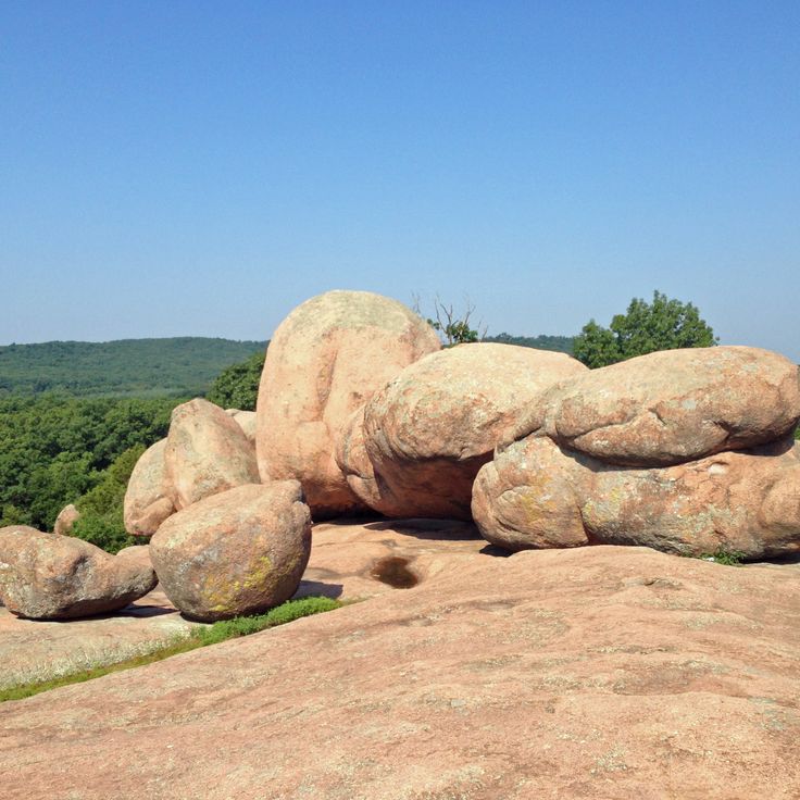
This park sits among the hills of Iron County and displays large granite boulders shaped by wind and water over millions of years. The rocks pile on top of each other and form tunnels and gaps where visitors can walk through. A paved trail leads between the smooth, rounded stone blocks that resemble the shape of elephants. The red granite shines in the sunlight and contrasts with the green forest around it. Families with children use the rocks for climbing and exploring, while photographers capture the unusual forms. The park shows how geological forces over long periods can create an extraordinary landscape.
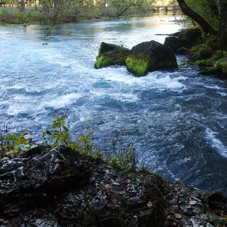
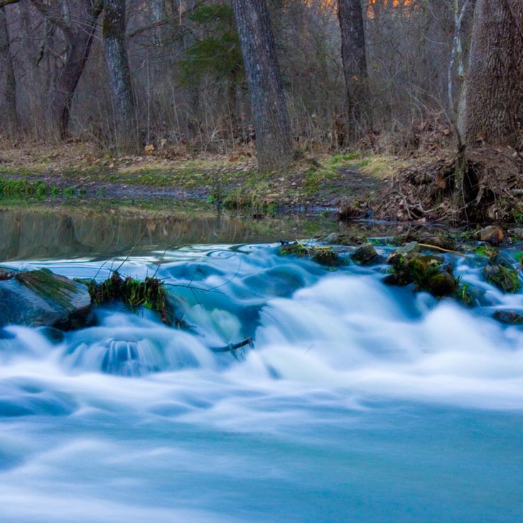
This spring lies in the Ozarks and releases about 286 million gallons of water each day. The water emerges at the base of a limestone wall and forms a clear pool before flowing into the Current River. Trees and shrubs grow around the spring, shading the banks and framing the water. Walking trails run along the rock faces and offer viewpoints over the spring basin. In summer the water stays cool and invites visitors to pause. The site ranks among the largest natural springs in North America.
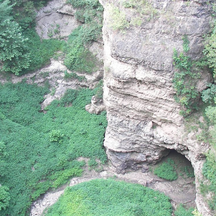
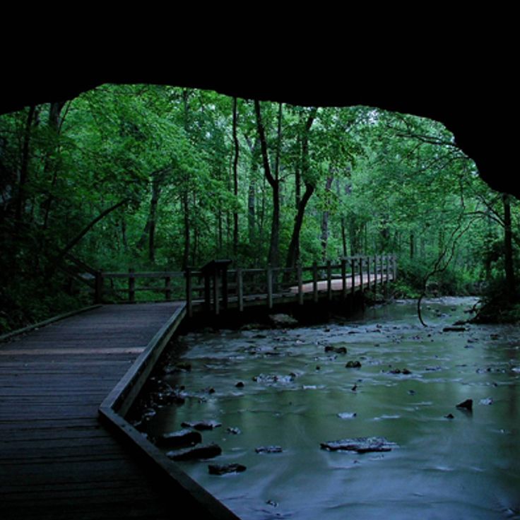
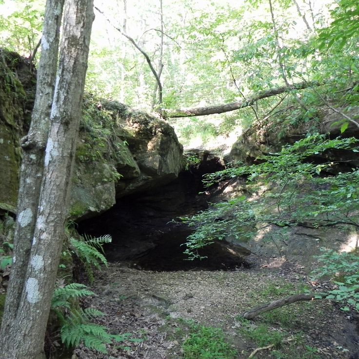
This park in Oregon County sits where a cave system collapsed and left behind a canyon with limestone walls. The opening runs about 1,300 feet (400 m) long and offers a view into underground formations exposed by erosion. Walking trails lead along the canyon rim and down to the floor, where a small stream flows through the rock formations. The walls show layers of gray and white limestone that formed over thousands of years.
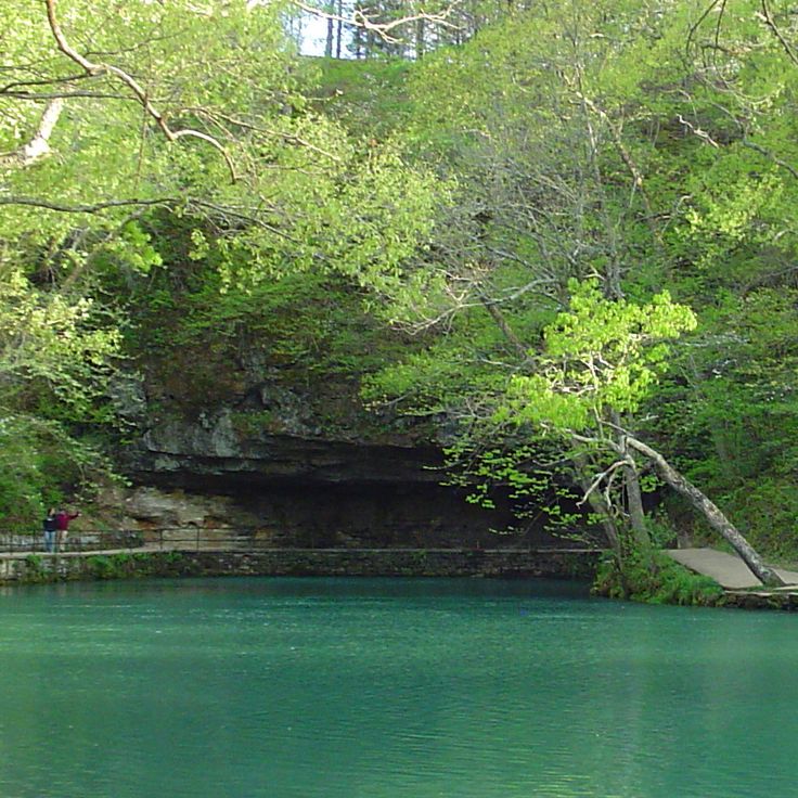
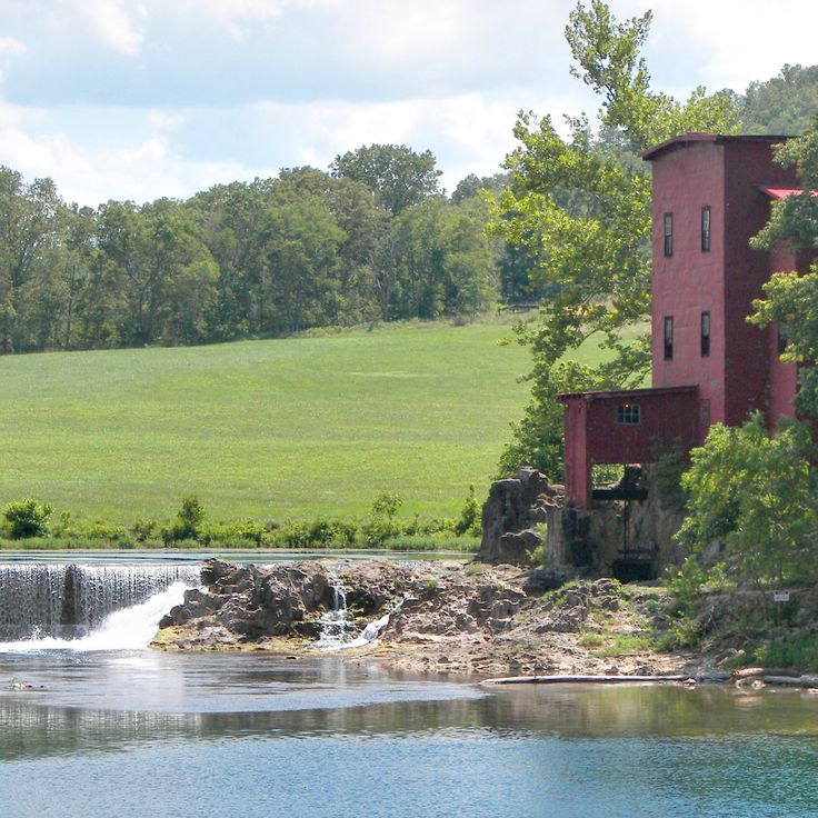
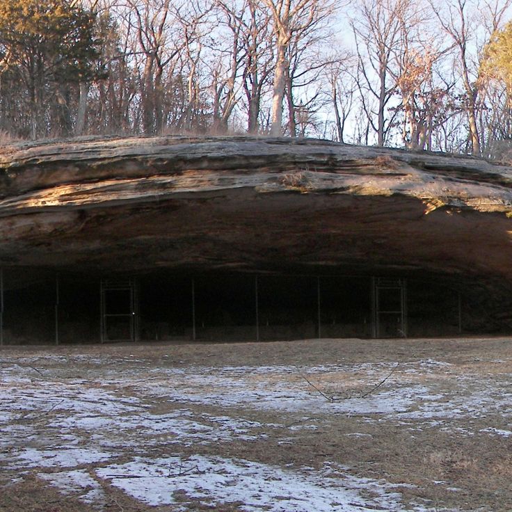
This historic park preserves a spring that produces millions of gallons of water each day, along with the remains of old ironworks. The site combines a natural water source with industrial history, showing how waterpower was once used. Walking trails follow the clear stream that flows from the spring. The ironworks ruins recall the time when iron was smelted here. The park is among the natural and historic places of Missouri, where springs and old industrial buildings shape the land.
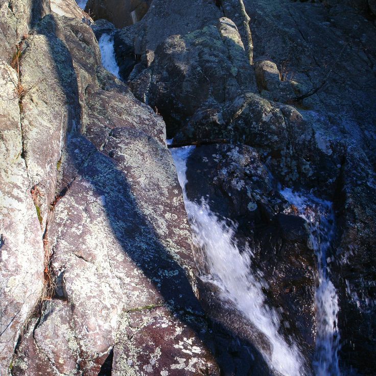
This natural area sits within dark pine forests and shows sandstone formations in warm red tones that contrast with the greenery. Water flows over rocks and forms small cascades. Trails lead between the trees, past native wildflowers that bloom in spring and summer. The rocks have been shaped by erosion over thousands of years and form ridges and overhangs. Visitors follow paths through an area that combines forests, stone structures, and waterways. The area demonstrates the geological features of Missouri, where soft sandstone layers create natural sculptures. Mosses and ferns grow in damp rock crevices.
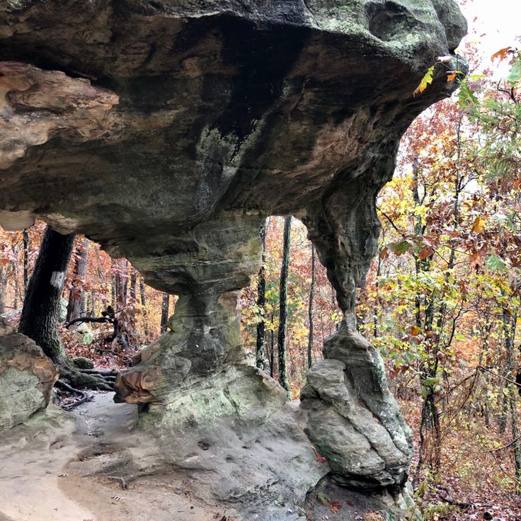
This park in northern Missouri protects an unusual limestone landscape with underground streams and caves. A natural arch spans a dry creek bed, forming a stone bridge about 17 feet high. Walking trails lead through forested areas and along bluffs where chalky rock becomes visible. Below the surface, streams flow through porous layers. Some sections open into small grottoes. The vegetation consists of hardwood forest and thick undergrowth. Visitors follow paths to the geological formations and can stand near the base of the arch. The park lies in rolling terrain typical of central Missouri.
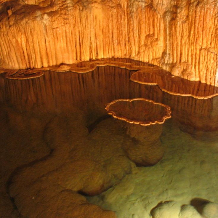
This limestone cave in Crawford County is among Missouri's natural sites, with underground lakes and mineral deposits. The cave system shows formations of calcite and aragonite that developed over thousands of years. Lighted pathways lead through several chambers with flowing water and dripstone features. Tours explain the geological processes and the history of the cave, which has been open to visitors since the 1930s. The temperature inside remains constant throughout the year at about 57 degrees Fahrenheit (14 degrees Celsius). The underground river has shaped passages and halls where stalactites and stalagmites form in different sizes.
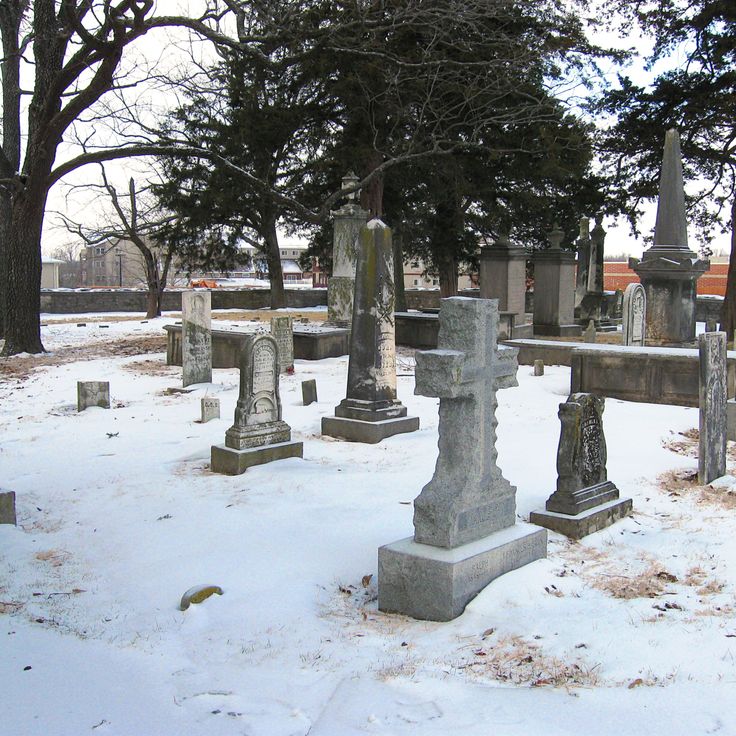
This cemetery from the 1800s holds the graves of several university presidents and early Missouri settlers. The headstones tell the stories of people who lived in the region when the state was still young. Some markers carry faded inscriptions, and a few graves belong to families who arrived here more than 150 years ago. Trees grow between the monuments, offering shade in summer months. The site sits quietly away from main roads, allowing visitors to reflect on the history preserved here. Walking among the graves, you notice the care taken to maintain this place for those who shaped the early days of the state.
This park south of the city covers 212 hectares (525 acres) along the Mississippi. The caves are among the geological attractions of Missouri and lead beneath the limestone formation. Hiking trails connect the different areas, and a visitor center provides information about the geology of the region. From several points you can see the river whose banks border the grounds. The underground passages belong to the accessible caverns in the state.
This park lies in the Ozarks and is known for its spring, which produces around 100 million gallons of water each day. The clear water draws anglers who fish for trout in the stream channels. Besides fishing zones, there are camping areas under trees and trails that follow the creek. A small museum presents exhibits on the history of the area and how the spring was used in earlier times. The landscape consists of forests, limestone rocks, and green meadows.
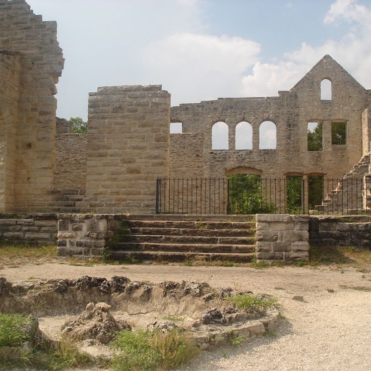
This park combines limestone formations and a large spring with the ruins of a castle built in 1905. The grounds include more than 15 caves that run through the underground rock layers. The stone ruins stand on a bluff overlooking the lake. Hiking trails lead through wooded hills to viewpoints, sinkholes, and rock walls. The spring emerges at the base of a cliff and flows down to the lake.
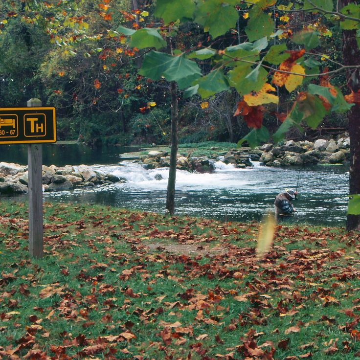
This park sits at the source of Current River and offers fishing along a two-mile stretch of the stream. A fish hatchery operates within the grounds. The area is part of Missouri's natural landscape of springs and historic sites. Trails follow the river through wooded hills.
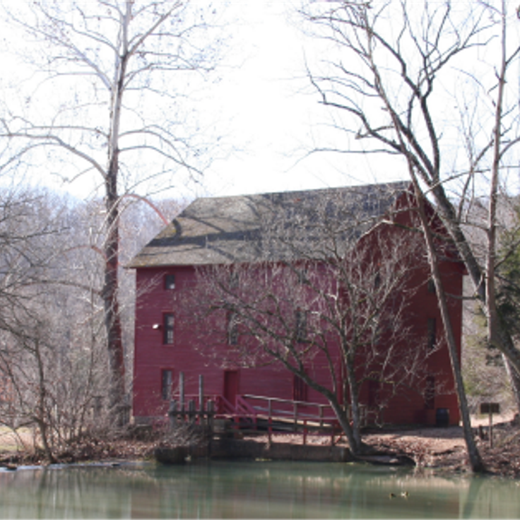
Alley Mill is a red stone watermill built in the 19th century at Alley Spring in Shannon County. Spring water powers the restored mill wheel. This mill belongs to the historic buildings that complement Missouri's natural landscape of springs, caves and geological formations. The structure stands between wooded hills and clear water, where hiking trails run and visitors can experience the connection between human work and natural resources.
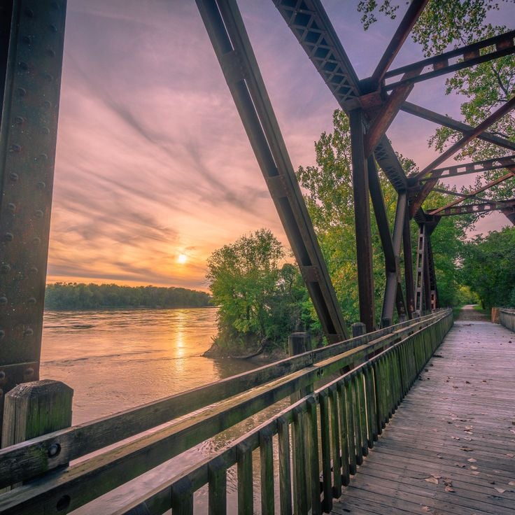
This former railroad path runs for 240 miles (386 km) through forests and fields along the Missouri River. The park uses the old rail bed for hikers and cyclists traveling between several towns across the state. The trail passes through farming regions and wooded sections where travelers see the river and the gentle hills of the surrounding land. Small communities along the route offer rest stops. The former rail line connects different landscapes of Missouri and shows how nature and past infrastructure come together today.
This park protects over 3700 acres of oak forest in western Missouri. Woodland trails lead through old tree stands and over gentle hills. The forests alternate between oak and hickory trees. Hiking paths connect clearings with denser woodland sections. In autumn, leaves turn warm colors. The park sits in a region of rolling hills and small waterways. Visitors find quiet among tall trees and can experience the original vegetation of the state.
Stoddard & Wayne Counties, Missouri, United States
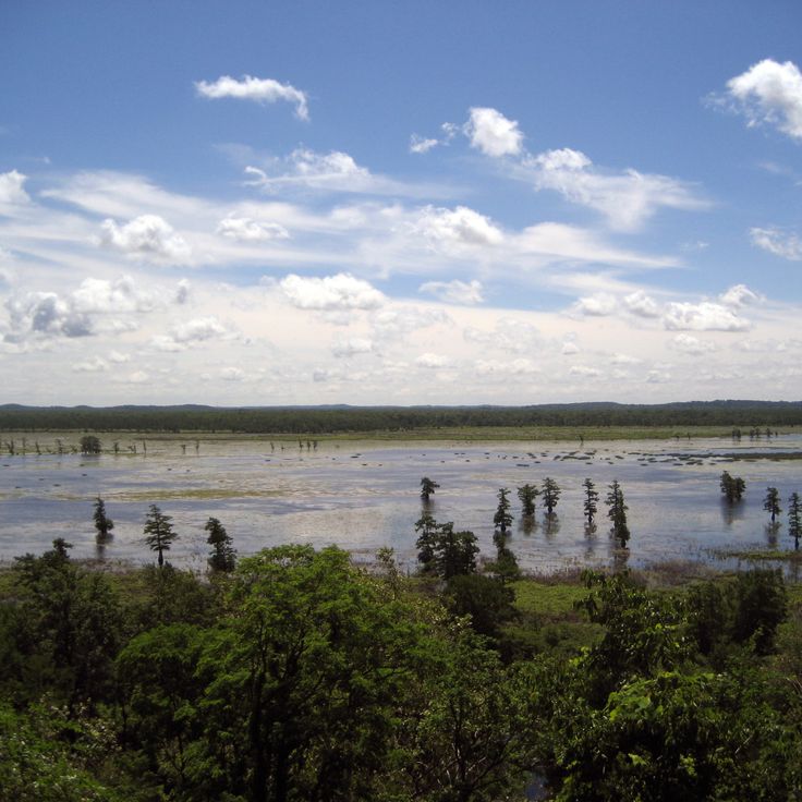
This refuge covers swampland and wetlands where waterfowl, raccoons, and bald eagles live. The landscape consists of flooded forests, shallow waters, and marshes that provide habitat for many species. Visitors can walk the trails through the area and observe birds. Mingo Wildlife Refuge is part of the natural reserves in Missouri where wetland ecosystems and their wildlife take center stage.
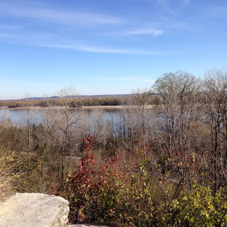
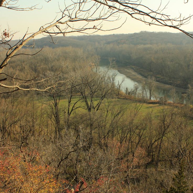
This park offers hiking trails along the Meramec River and shows remnants of historical recreation facilities from the 1920s. The paths lead through forests and rock formations, while old foundations and structures recall the earlier use as a recreation area. The river flows through deep valleys between steep limestone bluffs that reveal geological layers from millions of years ago. Visitors can choose between different routes, from short walks along the shore to longer climbs up the ridges with views over the river valley.
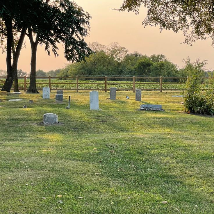
This cemetery holds the graves of the Sappington family, who shaped Missouri's trade networks during the 19th century. The site preserves a piece of early settler history and the families who took part in the state's economic development. Positioned on a hillside, the cemetery offers a sense of life and social structures from that period. The grounds remind visitors of the pioneers who influenced Missouri through their business ties and commercial routes. It stands as a quiet record of those who helped form the region's early commercial foundations.
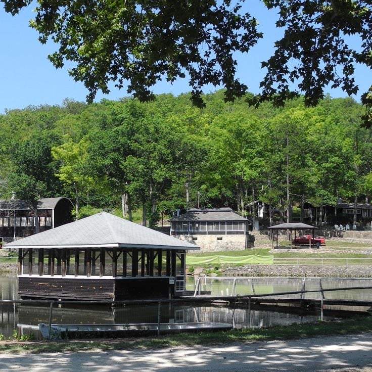
This park follows the river and offers space for canoeing and swimming in clear water. The banks are surrounded by forest, and nearby stand several buildings from the 1930s that were part of an old recreational program. Trails lead through the grounds and along the water. The river flows through Missouri and forms a quiet section for visitors who want to explore the natural setting and historic architecture of this region.
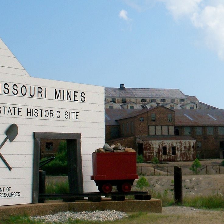
This historic site lies in the heart of St. Francois County and brings to life the world of mining during Missouri's mineral extraction peak. The exhibitions present tools, equipment, and minerals that tell the story of daily life for miners. Visitors can trace how iron and other raw materials were pulled from the ground. The buildings of this former mining complex convey a sense of the conditions on site.
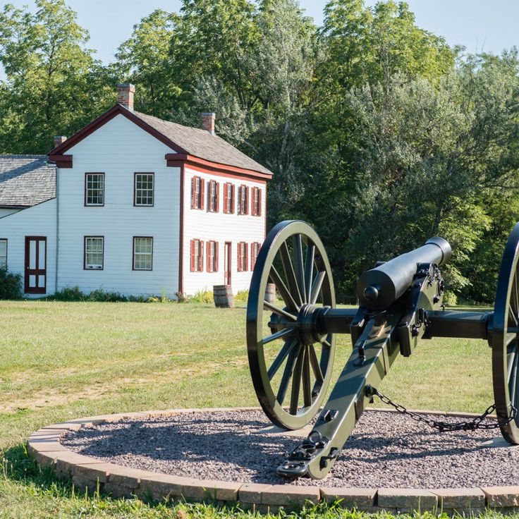
This historic site marks the 1861 military engagement between Union and Confederate forces near the Missouri-Iowa border. The place lies in rural northern Missouri and preserves the memory of an early Civil War battle. Visitors find information panels explaining the course of the fight, along with open fields that recall the events of that time. The site is one of Missouri's historic locations that, alongside natural springs and caves, makes places of human history accessible to travelers.
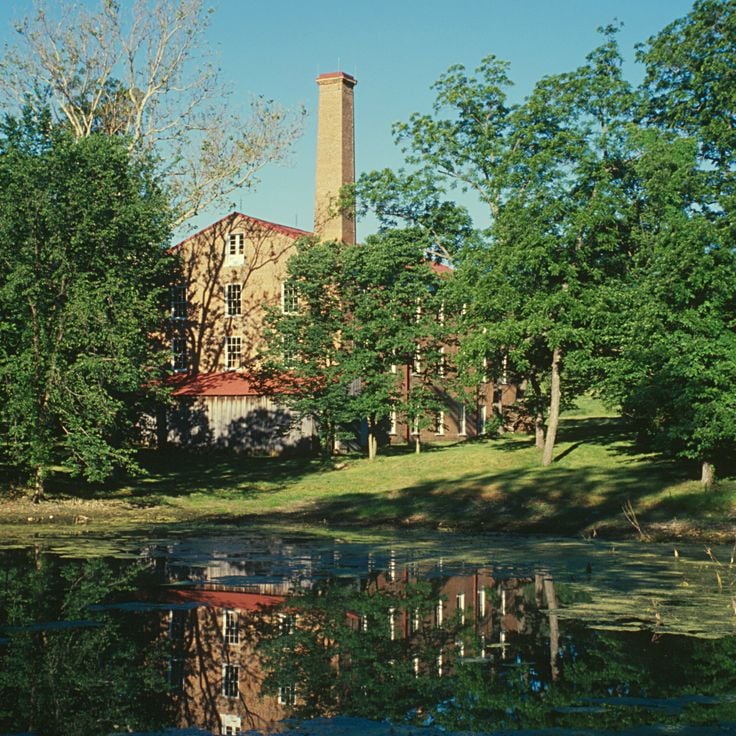
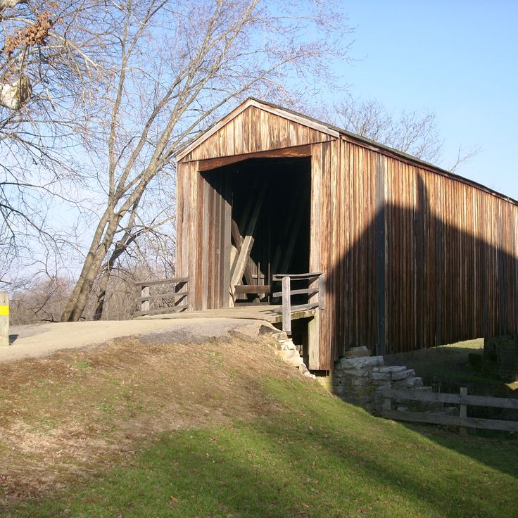
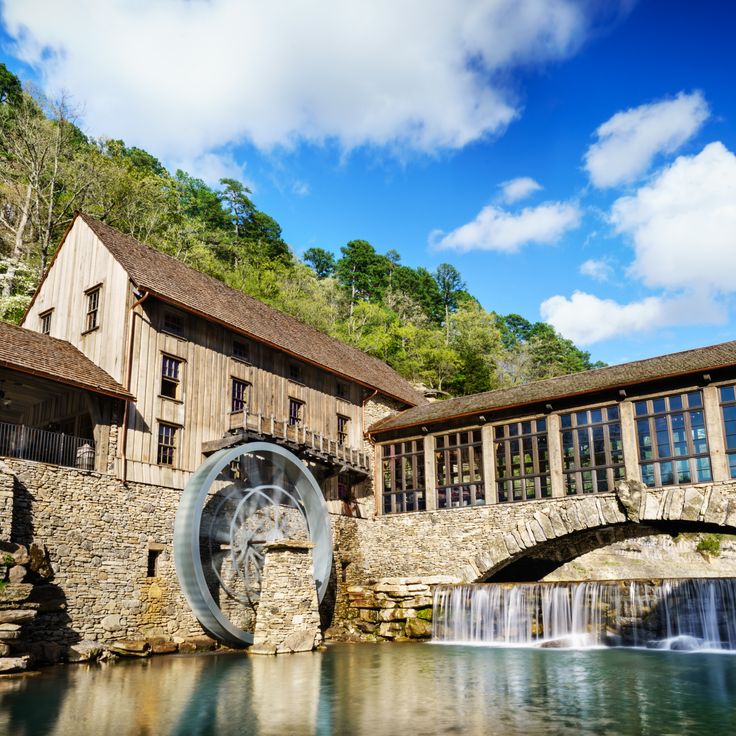
This 19th-century mill stands on the banks of the Whitewater River in Missouri. The site preserves its original grinding equipment and machinery that once processed grain into flour. A covered wooden bridge spans the river and connects directly to the mill building. The red brick structure rises several stories and reflects in the calm water below. Visitors can see the old millstones, wooden gears, and drive shafts that powered the operation. The bridge now serves as a walking path and offers views of the river and surrounding forest. The complex demonstrates how water power was harnessed to turn heavy stones and grind corn.
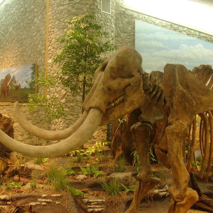
This site rests in the hills of Missouri and preserves remains of mastodons and other Ice Age animals. The grounds show excavation areas where bones and stone tools were uncovered. A museum presents skeletons and explains how humans and animals lived here thousands of years ago. Trails wind through woods and along streams where similar discoveries were made. The place connects paleontology with the natural surroundings of Missouri.
This nature park covers 4000 hectares (about 10,000 acres) of wooded land in southern Missouri. The landscape is cut through by several streams that flow down between limestone rocks and form smaller waterfalls. Marked walking trails lead through valleys with oak trees, walnuts, and flowering dogwoods that give the park its name. Stocked ponds hold trout that visitors can fish. The paths follow the waterways and provide access to meadows where bison and elk sometimes graze. The area preserves a piece of the Ozark landscape as it looked before the region was settled.
This cave extends through seven levels and contains documented limestone passages that branch beneath the Ozark Mountains. The system lies in the Ozark region and shows underground formations shaped by water over long periods. Visitors can explore parts of the passages, where stalactites, stalagmites, and other mineral deposits are visible. The cave remains cool and damp throughout the year. Guided tours follow lit pathways through different chambers. The grounds also include surface areas along the Meramec River with picnic spots and walking trails that complement Missouri's natural springs and geological structures.
This cave features underground lakes, mineral formations, and prehistoric animal bones. As one of Missouri's natural wonders, Jacob's Cave presents geological structures throughout its spacious chambers. Visitors can walk through the passages and observe the underground landscape up close. The cave preserves traces of past eras and adds to the natural variety that characterizes the state.
This mill stands along Huzzah Creek and dates to 1908. The red building preserves the original machinery used to grind grain. Visitors can follow the mechanics of the milling process and walk through rooms where flour was once produced. The creek runs right beside the complex and once powered the mill wheels. The structure shows how rural communities in Missouri processed grain in the early 20th century and how such mills operated in daily life.
This conservation area sits in the eastern Ozarks and features sandstone formations rising above wooded hills. Streams form small waterfalls among the rocks. More than eight hundred plant species grow here in forests and along creek banks. Trails lead through valleys and over ridges where visitors can observe the variety of vegetation.
Graham Cave State Park preserves a cave with stone tools and other artifacts from Native Americans dating back 8,000 years. Trails wind through the park, following the traces of early inhabitants. The cave sits protected in the rock, offering insight into life in prehistoric times. Archaeological discoveries show how people sought shelter here across thousands of years. This site adds a prehistoric dimension to Missouri's natural and historic landmarks, with its geological formations and hiking paths along wooded hillsides.
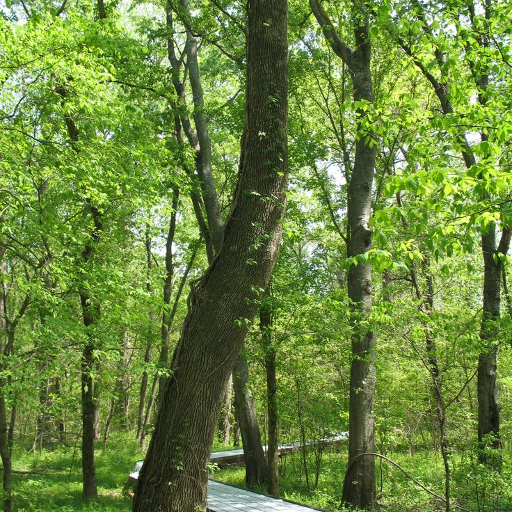
This park protects oak and hickory trees over a hundred years old in an original Mississippi Valley bottomland forest. The area shows how the forests looked before farming changed the region. Tall trees cast shade on the ground where ferns and wildflowers grow. Walking paths lead through the dense woods past old trunks and roots. In spring and summer you hear birds singing in the canopy. The forest sits in a flat landscape once flooded by the river.
This state park sits on the highest point in Missouri and offers views over the forested hills of the Saint Francois Mountains. The summit stands 1,772 feet above sea level and serves as a natural lookout for hikers. Granite rocks and old forests shape the landscape around it. The park connects with other protected areas in the region and forms part of the geological history of the state. Trails lead to the top, where visitors can see across the wooded valleys.
This textile factory from the pre-Civil War era displays wool processing machinery and equipment in their original positions. The park preserves a working 19th-century building among Missouri's historic sites. Visitors can view the mechanical looms, spinning wheels, and other devices that once powered wool production. The grounds connect industrial history with the natural surroundings of rural Missouri.
This park sits among the hills of Iron County and displays large granite boulders shaped by wind and water over millions of years. The rocks pile on top of each other and form tunnels and gaps where visitors can walk through. A paved trail leads between the smooth, rounded stone blocks that resemble the shape of elephants. The red granite shines in the sunlight and contrasts with the green forest around it. Families with children use the rocks for climbing and exploring, while photographers capture the unusual forms. The park shows how geological forces over long periods can create an extraordinary landscape.
This spring lies in the Ozarks and releases about 286 million gallons of water each day. The water emerges at the base of a limestone wall and forms a clear pool before flowing into the Current River. Trees and shrubs grow around the spring, shading the banks and framing the water. Walking trails run along the rock faces and offer viewpoints over the spring basin. In summer the water stays cool and invites visitors to pause. The site ranks among the largest natural springs in North America.
This park in Oregon County sits where a cave system collapsed and left behind a canyon with limestone walls. The opening runs about 1,300 feet (400 m) long and offers a view into underground formations exposed by erosion. Walking trails lead along the canyon rim and down to the floor, where a small stream flows through the rock formations. The walls show layers of gray and white limestone that formed over thousands of years.
This historic park preserves a spring that produces millions of gallons of water each day, along with the remains of old ironworks. The site combines a natural water source with industrial history, showing how waterpower was once used. Walking trails follow the clear stream that flows from the spring. The ironworks ruins recall the time when iron was smelted here. The park is among the natural and historic places of Missouri, where springs and old industrial buildings shape the land.
This natural area sits within dark pine forests and shows sandstone formations in warm red tones that contrast with the greenery. Water flows over rocks and forms small cascades. Trails lead between the trees, past native wildflowers that bloom in spring and summer. The rocks have been shaped by erosion over thousands of years and form ridges and overhangs. Visitors follow paths through an area that combines forests, stone structures, and waterways. The area demonstrates the geological features of Missouri, where soft sandstone layers create natural sculptures. Mosses and ferns grow in damp rock crevices.
This park in northern Missouri protects an unusual limestone landscape with underground streams and caves. A natural arch spans a dry creek bed, forming a stone bridge about 17 feet high. Walking trails lead through forested areas and along bluffs where chalky rock becomes visible. Below the surface, streams flow through porous layers. Some sections open into small grottoes. The vegetation consists of hardwood forest and thick undergrowth. Visitors follow paths to the geological formations and can stand near the base of the arch. The park lies in rolling terrain typical of central Missouri.
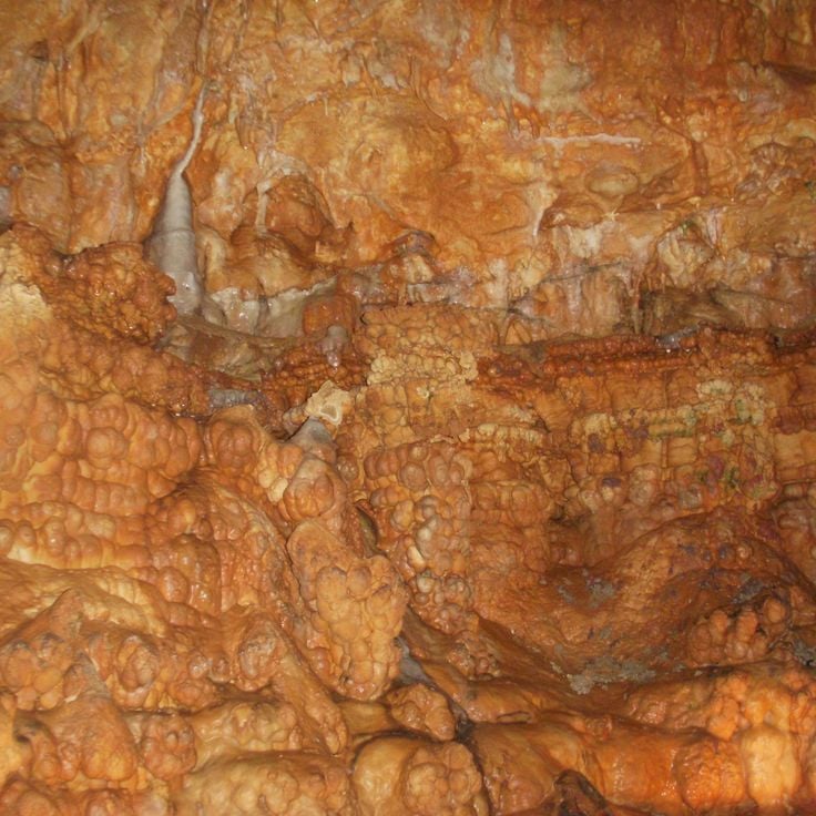
This limestone cave in Crawford County is among Missouri's natural sites, with underground lakes and mineral deposits. The cave system shows formations of calcite and aragonite that developed over thousands of years. Lighted pathways lead through several chambers with flowing water and dripstone features. Tours explain the geological processes and the history of the cave, which has been open to visitors since the 1930s. The temperature inside remains constant throughout the year at about 57 degrees Fahrenheit (14 degrees Celsius). The underground river has shaped passages and halls where stalactites and stalagmites form in different sizes.
This cemetery from the 1800s holds the graves of several university presidents and early Missouri settlers. The headstones tell the stories of people who lived in the region when the state was still young. Some markers carry faded inscriptions, and a few graves belong to families who arrived here more than 150 years ago. Trees grow between the monuments, offering shade in summer months. The site sits quietly away from main roads, allowing visitors to reflect on the history preserved here. Walking among the graves, you notice the care taken to maintain this place for those who shaped the early days of the state.
This park south of the city covers 212 hectares (525 acres) along the Mississippi. The caves are among the geological attractions of Missouri and lead beneath the limestone formation. Hiking trails connect the different areas, and a visitor center provides information about the geology of the region. From several points you can see the river whose banks border the grounds. The underground passages belong to the accessible caverns in the state.
This park lies in the Ozarks and is known for its spring, which produces around 100 million gallons of water each day. The clear water draws anglers who fish for trout in the stream channels. Besides fishing zones, there are camping areas under trees and trails that follow the creek. A small museum presents exhibits on the history of the area and how the spring was used in earlier times. The landscape consists of forests, limestone rocks, and green meadows.
This park combines limestone formations and a large spring with the ruins of a castle built in 1905. The grounds include more than 15 caves that run through the underground rock layers. The stone ruins stand on a bluff overlooking the lake. Hiking trails lead through wooded hills to viewpoints, sinkholes, and rock walls. The spring emerges at the base of a cliff and flows down to the lake.
This park sits at the source of Current River and offers fishing along a two-mile stretch of the stream. A fish hatchery operates within the grounds. The area is part of Missouri's natural landscape of springs and historic sites. Trails follow the river through wooded hills.
Alley Mill is a red stone watermill built in the 19th century at Alley Spring in Shannon County. Spring water powers the restored mill wheel. This mill belongs to the historic buildings that complement Missouri's natural landscape of springs, caves and geological formations. The structure stands between wooded hills and clear water, where hiking trails run and visitors can experience the connection between human work and natural resources.
This former railroad path runs for 240 miles (386 km) through forests and fields along the Missouri River. The park uses the old rail bed for hikers and cyclists traveling between several towns across the state. The trail passes through farming regions and wooded sections where travelers see the river and the gentle hills of the surrounding land. Small communities along the route offer rest stops. The former rail line connects different landscapes of Missouri and shows how nature and past infrastructure come together today.
This park protects over 3700 acres of oak forest in western Missouri. Woodland trails lead through old tree stands and over gentle hills. The forests alternate between oak and hickory trees. Hiking paths connect clearings with denser woodland sections. In autumn, leaves turn warm colors. The park sits in a region of rolling hills and small waterways. Visitors find quiet among tall trees and can experience the original vegetation of the state.
Stoddard & Wayne Counties, Missouri, United States
This refuge covers swampland and wetlands where waterfowl, raccoons, and bald eagles live. The landscape consists of flooded forests, shallow waters, and marshes that provide habitat for many species. Visitors can walk the trails through the area and observe birds. Mingo Wildlife Refuge is part of the natural reserves in Missouri where wetland ecosystems and their wildlife take center stage.
This park offers hiking trails along the Meramec River and shows remnants of historical recreation facilities from the 1920s. The paths lead through forests and rock formations, while old foundations and structures recall the earlier use as a recreation area. The river flows through deep valleys between steep limestone bluffs that reveal geological layers from millions of years ago. Visitors can choose between different routes, from short walks along the shore to longer climbs up the ridges with views over the river valley.
This cemetery holds the graves of the Sappington family, who shaped Missouri's trade networks during the 19th century. The site preserves a piece of early settler history and the families who took part in the state's economic development. Positioned on a hillside, the cemetery offers a sense of life and social structures from that period. The grounds remind visitors of the pioneers who influenced Missouri through their business ties and commercial routes. It stands as a quiet record of those who helped form the region's early commercial foundations.
This park follows the river and offers space for canoeing and swimming in clear water. The banks are surrounded by forest, and nearby stand several buildings from the 1930s that were part of an old recreational program. Trails lead through the grounds and along the water. The river flows through Missouri and forms a quiet section for visitors who want to explore the natural setting and historic architecture of this region.
This historic site lies in the heart of St. Francois County and brings to life the world of mining during Missouri's mineral extraction peak. The exhibitions present tools, equipment, and minerals that tell the story of daily life for miners. Visitors can trace how iron and other raw materials were pulled from the ground. The buildings of this former mining complex convey a sense of the conditions on site.
This historic site marks the 1861 military engagement between Union and Confederate forces near the Missouri-Iowa border. The place lies in rural northern Missouri and preserves the memory of an early Civil War battle. Visitors find information panels explaining the course of the fight, along with open fields that recall the events of that time. The site is one of Missouri's historic locations that, alongside natural springs and caves, makes places of human history accessible to travelers.
This 19th-century mill stands on the banks of the Whitewater River in Missouri. The site preserves its original grinding equipment and machinery that once processed grain into flour. A covered wooden bridge spans the river and connects directly to the mill building. The red brick structure rises several stories and reflects in the calm water below. Visitors can see the old millstones, wooden gears, and drive shafts that powered the operation. The bridge now serves as a walking path and offers views of the river and surrounding forest. The complex demonstrates how water power was harnessed to turn heavy stones and grind corn.
This site rests in the hills of Missouri and preserves remains of mastodons and other Ice Age animals. The grounds show excavation areas where bones and stone tools were uncovered. A museum presents skeletons and explains how humans and animals lived here thousands of years ago. Trails wind through woods and along streams where similar discoveries were made. The place connects paleontology with the natural surroundings of Missouri.
This nature park covers 4000 hectares (about 10,000 acres) of wooded land in southern Missouri. The landscape is cut through by several streams that flow down between limestone rocks and form smaller waterfalls. Marked walking trails lead through valleys with oak trees, walnuts, and flowering dogwoods that give the park its name. Stocked ponds hold trout that visitors can fish. The paths follow the waterways and provide access to meadows where bison and elk sometimes graze. The area preserves a piece of the Ozark landscape as it looked before the region was settled.
This cave extends through seven levels and contains documented limestone passages that branch beneath the Ozark Mountains. The system lies in the Ozark region and shows underground formations shaped by water over long periods. Visitors can explore parts of the passages, where stalactites, stalagmites, and other mineral deposits are visible. The cave remains cool and damp throughout the year. Guided tours follow lit pathways through different chambers. The grounds also include surface areas along the Meramec River with picnic spots and walking trails that complement Missouri's natural springs and geological structures.
This cave features underground lakes, mineral formations, and prehistoric animal bones. As one of Missouri's natural wonders, Jacob's Cave presents geological structures throughout its spacious chambers. Visitors can walk through the passages and observe the underground landscape up close. The cave preserves traces of past eras and adds to the natural variety that characterizes the state.
This mill stands along Huzzah Creek and dates to 1908. The red building preserves the original machinery used to grind grain. Visitors can follow the mechanics of the milling process and walk through rooms where flour was once produced. The creek runs right beside the complex and once powered the mill wheels. The structure shows how rural communities in Missouri processed grain in the early 20th century and how such mills operated in daily life.
This conservation area sits in the eastern Ozarks and features sandstone formations rising above wooded hills. Streams form small waterfalls among the rocks. More than eight hundred plant species grow here in forests and along creek banks. Trails lead through valleys and over ridges where visitors can observe the variety of vegetation.
Graham Cave State Park preserves a cave with stone tools and other artifacts from Native Americans dating back 8,000 years. Trails wind through the park, following the traces of early inhabitants. The cave sits protected in the rock, offering insight into life in prehistoric times. Archaeological discoveries show how people sought shelter here across thousands of years. This site adds a prehistoric dimension to Missouri's natural and historic landmarks, with its geological formations and hiking paths along wooded hillsides.
This park protects oak and hickory trees over a hundred years old in an original Mississippi Valley bottomland forest. The area shows how the forests looked before farming changed the region. Tall trees cast shade on the ground where ferns and wildflowers grow. Walking paths lead through the dense woods past old trunks and roots. In spring and summer you hear birds singing in the canopy. The forest sits in a flat landscape once flooded by the river.
This state park sits on the highest point in Missouri and offers views over the forested hills of the Saint Francois Mountains. The summit stands 1,772 feet above sea level and serves as a natural lookout for hikers. Granite rocks and old forests shape the landscape around it. The park connects with other protected areas in the region and forms part of the geological history of the state. Trails lead to the top, where visitors can see across the wooded valleys.
This textile factory from the pre-Civil War era displays wool processing machinery and equipment in their original positions. The park preserves a working 19th-century building among Missouri's historic sites. Visitors can view the mechanical looms, spinning wheels, and other devices that once powered wool production. The grounds connect industrial history with the natural surroundings of rural Missouri.
This park sits among the hills of Iron County and displays large granite boulders shaped by wind and water over millions of years. The rocks pile on top of each other and form tunnels and gaps where visitors can walk through. A paved trail leads between the smooth, rounded stone blocks that resemble the shape of elephants. The red granite shines in the sunlight and contrasts with the green forest around it. Families with children use the rocks for climbing and exploring, while photographers capture the unusual forms. The park shows how geological forces over long periods can create an extraordinary landscape.
This spring lies in the Ozarks and releases about 286 million gallons of water each day. The water emerges at the base of a limestone wall and forms a clear pool before flowing into the Current River. Trees and shrubs grow around the spring, shading the banks and framing the water. Walking trails run along the rock faces and offer viewpoints over the spring basin. In summer the water stays cool and invites visitors to pause. The site ranks among the largest natural springs in North America.
This park in Oregon County sits where a cave system collapsed and left behind a canyon with limestone walls. The opening runs about 1,300 feet (400 m) long and offers a view into underground formations exposed by erosion. Walking trails lead along the canyon rim and down to the floor, where a small stream flows through the rock formations. The walls show layers of gray and white limestone that formed over thousands of years.
This historic park preserves a spring that produces millions of gallons of water each day, along with the remains of old ironworks. The site combines a natural water source with industrial history, showing how waterpower was once used. Walking trails follow the clear stream that flows from the spring. The ironworks ruins recall the time when iron was smelted here. The park is among the natural and historic places of Missouri, where springs and old industrial buildings shape the land.
This natural area sits within dark pine forests and shows sandstone formations in warm red tones that contrast with the greenery. Water flows over rocks and forms small cascades. Trails lead between the trees, past native wildflowers that bloom in spring and summer. The rocks have been shaped by erosion over thousands of years and form ridges and overhangs. Visitors follow paths through an area that combines forests, stone structures, and waterways. The area demonstrates the geological features of Missouri, where soft sandstone layers create natural sculptures. Mosses and ferns grow in damp rock crevices.
This park in northern Missouri protects an unusual limestone landscape with underground streams and caves. A natural arch spans a dry creek bed, forming a stone bridge about 17 feet high. Walking trails lead through forested areas and along bluffs where chalky rock becomes visible. Below the surface, streams flow through porous layers. Some sections open into small grottoes. The vegetation consists of hardwood forest and thick undergrowth. Visitors follow paths to the geological formations and can stand near the base of the arch. The park lies in rolling terrain typical of central Missouri.
This limestone cave in Crawford County is among Missouri's natural sites, with underground lakes and mineral deposits. The cave system shows formations of calcite and aragonite that developed over thousands of years. Lighted pathways lead through several chambers with flowing water and dripstone features. Tours explain the geological processes and the history of the cave, which has been open to visitors since the 1930s. The temperature inside remains constant throughout the year at about 57 degrees Fahrenheit (14 degrees Celsius). The underground river has shaped passages and halls where stalactites and stalagmites form in different sizes.
This cemetery from the 1800s holds the graves of several university presidents and early Missouri settlers. The headstones tell the stories of people who lived in the region when the state was still young. Some markers carry faded inscriptions, and a few graves belong to families who arrived here more than 150 years ago. Trees grow between the monuments, offering shade in summer months. The site sits quietly away from main roads, allowing visitors to reflect on the history preserved here. Walking among the graves, you notice the care taken to maintain this place for those who shaped the early days of the state.
This park south of the city covers 212 hectares (525 acres) along the Mississippi. The caves are among the geological attractions of Missouri and lead beneath the limestone formation. Hiking trails connect the different areas, and a visitor center provides information about the geology of the region. From several points you can see the river whose banks border the grounds. The underground passages belong to the accessible caverns in the state.
This park lies in the Ozarks and is known for its spring, which produces around 100 million gallons of water each day. The clear water draws anglers who fish for trout in the stream channels. Besides fishing zones, there are camping areas under trees and trails that follow the creek. A small museum presents exhibits on the history of the area and how the spring was used in earlier times. The landscape consists of forests, limestone rocks, and green meadows.
This park combines limestone formations and a large spring with the ruins of a castle built in 1905. The grounds include more than 15 caves that run through the underground rock layers. The stone ruins stand on a bluff overlooking the lake. Hiking trails lead through wooded hills to viewpoints, sinkholes, and rock walls. The spring emerges at the base of a cliff and flows down to the lake.
This park sits at the source of Current River and offers fishing along a two-mile stretch of the stream. A fish hatchery operates within the grounds. The area is part of Missouri's natural landscape of springs and historic sites. Trails follow the river through wooded hills.
Alley Mill is a red stone watermill built in the 19th century at Alley Spring in Shannon County. Spring water powers the restored mill wheel. This mill belongs to the historic buildings that complement Missouri's natural landscape of springs, caves and geological formations. The structure stands between wooded hills and clear water, where hiking trails run and visitors can experience the connection between human work and natural resources.
This former railroad path runs for 240 miles (386 km) through forests and fields along the Missouri River. The park uses the old rail bed for hikers and cyclists traveling between several towns across the state. The trail passes through farming regions and wooded sections where travelers see the river and the gentle hills of the surrounding land. Small communities along the route offer rest stops. The former rail line connects different landscapes of Missouri and shows how nature and past infrastructure come together today.
This park protects over 3700 acres of oak forest in western Missouri. Woodland trails lead through old tree stands and over gentle hills. The forests alternate between oak and hickory trees. Hiking paths connect clearings with denser woodland sections. In autumn, leaves turn warm colors. The park sits in a region of rolling hills and small waterways. Visitors find quiet among tall trees and can experience the original vegetation of the state.
Stoddard & Wayne Counties, Missouri, United States
This refuge covers swampland and wetlands where waterfowl, raccoons, and bald eagles live. The landscape consists of flooded forests, shallow waters, and marshes that provide habitat for many species. Visitors can walk the trails through the area and observe birds. Mingo Wildlife Refuge is part of the natural reserves in Missouri where wetland ecosystems and their wildlife take center stage.
This park offers hiking trails along the Meramec River and shows remnants of historical recreation facilities from the 1920s. The paths lead through forests and rock formations, while old foundations and structures recall the earlier use as a recreation area. The river flows through deep valleys between steep limestone bluffs that reveal geological layers from millions of years ago. Visitors can choose between different routes, from short walks along the shore to longer climbs up the ridges with views over the river valley.
This cemetery holds the graves of the Sappington family, who shaped Missouri's trade networks during the 19th century. The site preserves a piece of early settler history and the families who took part in the state's economic development. Positioned on a hillside, the cemetery offers a sense of life and social structures from that period. The grounds remind visitors of the pioneers who influenced Missouri through their business ties and commercial routes. It stands as a quiet record of those who helped form the region's early commercial foundations.
This park follows the river and offers space for canoeing and swimming in clear water. The banks are surrounded by forest, and nearby stand several buildings from the 1930s that were part of an old recreational program. Trails lead through the grounds and along the water. The river flows through Missouri and forms a quiet section for visitors who want to explore the natural setting and historic architecture of this region.
This historic site lies in the heart of St. Francois County and brings to life the world of mining during Missouri's mineral extraction peak. The exhibitions present tools, equipment, and minerals that tell the story of daily life for miners. Visitors can trace how iron and other raw materials were pulled from the ground. The buildings of this former mining complex convey a sense of the conditions on site.
This historic site marks the 1861 military engagement between Union and Confederate forces near the Missouri-Iowa border. The place lies in rural northern Missouri and preserves the memory of an early Civil War battle. Visitors find information panels explaining the course of the fight, along with open fields that recall the events of that time. The site is one of Missouri's historic locations that, alongside natural springs and caves, makes places of human history accessible to travelers.
This 19th-century mill stands on the banks of the Whitewater River in Missouri. The site preserves its original grinding equipment and machinery that once processed grain into flour. A covered wooden bridge spans the river and connects directly to the mill building. The red brick structure rises several stories and reflects in the calm water below. Visitors can see the old millstones, wooden gears, and drive shafts that powered the operation. The bridge now serves as a walking path and offers views of the river and surrounding forest. The complex demonstrates how water power was harnessed to turn heavy stones and grind corn.
This site rests in the hills of Missouri and preserves remains of mastodons and other Ice Age animals. The grounds show excavation areas where bones and stone tools were uncovered. A museum presents skeletons and explains how humans and animals lived here thousands of years ago. Trails wind through woods and along streams where similar discoveries were made. The place connects paleontology with the natural surroundings of Missouri.
This nature park covers 4000 hectares (about 10,000 acres) of wooded land in southern Missouri. The landscape is cut through by several streams that flow down between limestone rocks and form smaller waterfalls. Marked walking trails lead through valleys with oak trees, walnuts, and flowering dogwoods that give the park its name. Stocked ponds hold trout that visitors can fish. The paths follow the waterways and provide access to meadows where bison and elk sometimes graze. The area preserves a piece of the Ozark landscape as it looked before the region was settled.
This cave extends through seven levels and contains documented limestone passages that branch beneath the Ozark Mountains. The system lies in the Ozark region and shows underground formations shaped by water over long periods. Visitors can explore parts of the passages, where stalactites, stalagmites, and other mineral deposits are visible. The cave remains cool and damp throughout the year. Guided tours follow lit pathways through different chambers. The grounds also include surface areas along the Meramec River with picnic spots and walking trails that complement Missouri's natural springs and geological structures.
This cave features underground lakes, mineral formations, and prehistoric animal bones. As one of Missouri's natural wonders, Jacob's Cave presents geological structures throughout its spacious chambers. Visitors can walk through the passages and observe the underground landscape up close. The cave preserves traces of past eras and adds to the natural variety that characterizes the state.
This mill stands along Huzzah Creek and dates to 1908. The red building preserves the original machinery used to grind grain. Visitors can follow the mechanics of the milling process and walk through rooms where flour was once produced. The creek runs right beside the complex and once powered the mill wheels. The structure shows how rural communities in Missouri processed grain in the early 20th century and how such mills operated in daily life.
This conservation area sits in the eastern Ozarks and features sandstone formations rising above wooded hills. Streams form small waterfalls among the rocks. More than eight hundred plant species grow here in forests and along creek banks. Trails lead through valleys and over ridges where visitors can observe the variety of vegetation.
Graham Cave State Park preserves a cave with stone tools and other artifacts from Native Americans dating back 8,000 years. Trails wind through the park, following the traces of early inhabitants. The cave sits protected in the rock, offering insight into life in prehistoric times. Archaeological discoveries show how people sought shelter here across thousands of years. This site adds a prehistoric dimension to Missouri's natural and historic landmarks, with its geological formations and hiking paths along wooded hillsides.
This park protects oak and hickory trees over a hundred years old in an original Mississippi Valley bottomland forest. The area shows how the forests looked before farming changed the region. Tall trees cast shade on the ground where ferns and wildflowers grow. Walking paths lead through the dense woods past old trunks and roots. In spring and summer you hear birds singing in the canopy. The forest sits in a flat landscape once flooded by the river.
This state park sits on the highest point in Missouri and offers views over the forested hills of the Saint Francois Mountains. The summit stands 1,772 feet above sea level and serves as a natural lookout for hikers. Granite rocks and old forests shape the landscape around it. The park connects with other protected areas in the region and forms part of the geological history of the state. Trails lead to the top, where visitors can see across the wooded valleys.
This textile factory from the pre-Civil War era displays wool processing machinery and equipment in their original positions. The park preserves a working 19th-century building among Missouri's historic sites. Visitors can view the mechanical looms, spinning wheels, and other devices that once powered wool production. The grounds connect industrial history with the natural surroundings of rural Missouri.