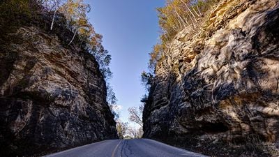
Enable Location

We need your location to show you interesting places around you

Discover nearby places

Find interesting locations and hidden gems around you

Precise directions

Get accurate directions and distances to places

Your location is never shared with other users. It's only used when you tap the location button.

Mindoro Cut

Log in to your account

Start exploring — it's free

Trusted by 62,422 travelers worldwide

Continue with Google
Continue with Apple
or

We will send you a code to connect

By continuing, you accept our Terms and Conditions and our Privacy Policy

Check your inbox

We've sent a pincode in your inbox. Please enter the code below.

Mindoro Cut

Mindoro Cut is a carved passage through dolomite rock along State Highway 108 in Wisconsin, where the road cuts approximately 75 feet deep and extends about 86 feet in length with a width of 25 feet. The passage creates a distinctive sunken roadway that guides travelers through what was once an impassable steep ridge.

The cut was carved between 1907 and 1908 primarily by hand labor using simple tools and dynamite to pierce through an otherwise impassable ridge. This effort helped establish better connections between Mindoro and nearby towns like West Salem, transforming local transportation and commerce during the early automotive age.

The cut represents a turning point when local communities invested in better transportation to serve farmers and traders. It stands today as a testament to how people came together to reshape the land for practical progress.

The site is accessible by car along State Highway 108, and visitors can pull over to view the cut up close from the roadside or walk around the surrounding area to appreciate its scale. The site is open year-round with no restrictions, though visiting during clear weather provides better visibility of the carved rock walls.

Mindoro Cut ranks as the second-deepest hand-dug rock cut in the western United States, a distinction that reflects the remarkable engineering effort required. Workers balanced wheelbarrows on narrow planks suspended over the slope while removing rock and earth, a perilous task that tested their skill and courage during the excavation.

The community of curious travelers

AroundUs brings together thousands of curated places, local tips, and hidden gems, enriched daily by 60,000 contributors worldwide.

Start exploring
Location
GPS coordinates
43.97390,-91.09510
Latest update
February 9, 2026 08:23
Around this place
I-90 Mississippi River Bridge
United States of America

I-90 Mississippi River Bridge

20.9 km
United States of America

La Crosse Fairgrounds Speedway

7.8 km
Lock and Dam No. 7
United States of America

Lock and Dam No. 7

20.8 km
Mississippi River Bridge
United States of America

Mississippi River Bridge

22.6 km
St. Rose of Viterbo Convent
United States of America

St. Rose of Viterbo Convent

22.4 km
La Crosse Rail Bridge
United States of America

La Crosse Rail Bridge

20.5 km
Statue of Hiawatha
United States of America

Statue of Hiawatha

21.6 km
United States of America

Riverside Park

21.9 km
Hamlin Garland House
United States of America

Hamlin Garland House

8.4 km
Freight House
United States of America

Freight House

21.7 km
La Crosse West Channel Bridge
United States of America

La Crosse West Channel Bridge

22.4 km
Mons Anderson House
United States of America

Mons Anderson House

22.3 km
Christ Episcopal Church
United States of America

Christ Episcopal Church

21.7 km
Gideon C. Hixon House
United States of America

Gideon C. Hixon House

21.4 km
Our Lady of Sorrows Chapel
United States of America

Our Lady of Sorrows Chapel

21.3 km
Bridge No. 4
United States of America

Bridge No. 4

18.9 km
La Crosse Commercial Historic District
United States of America

La Crosse Commercial Historic District

22 km
Palmer Brothers Octagons
United States of America

Palmer Brothers Octagons

8.1 km
Wittich Hall
United States of America

Wittich Hall

20.8 km
10th and Cass Streets Neighborhood Historic District
United States of America

10th and Cass Streets Neighborhood Historic District

21.5 km
Pla-mor
United States of America

Pla-mor

22.6 km
Frank Eugene Nichols House
United States of America

Frank Eugene Nichols House

14.9 km
John L. Callahan House
United States of America

John L. Callahan House

19.5 km
23rd and 24th Streets Historic District
United States of America

23rd and 24th Streets Historic District

20.4 km
Wegner Grotto
United States of America

Wegner Grotto

20.6 km
Rivoli Theatre
United States of America

Rivoli Theatre

21.9 km
LaCrosse State Teachers College Training School Building
United States of America

LaCrosse State Teachers College Training School Building

21 km
Van Loon Wildlife Area
United States of America

Van Loon Wildlife Area

19.1 km
Show the full map
« Mindoro Cut » is provided by Around Us (aroundus.com). Images and texts are derived from Wikimedia project under a Creative Commons license. You are allowed to copy, distribute, and modify copies of this page, under the conditions set by the license, as long as this note is clearly visible.

Discover hidden gems everywhere you go!

From secret cafés to breathtaking viewpoints, skip the crowded tourist spots and find places that match your style. Our app makes it easy with voice search, smart filtering, route optimization, and insider tips from travelers worldwide. Download now for the complete mobile experience.

Around Us App Screenshot

A unique approach to discovering new places

Le Figaro

All the places worth exploring

France Info

A tailor-made excursion in just a few clicks

20 Minutes

Around Us
Travel Guide & Maps
Download

Send to your phone

QR Code
1

Open the camera app on your mobile.

2

Point at the QR code with your camera. A notification will appear.

3

Tap the notification to open the link.