Enable Location

We need your location to show you interesting places around you

Discover nearby places

Find interesting locations and hidden gems around you

Precise directions

Get accurate directions and distances to places

Your location is never shared with other users. It's only used when you tap the location button.

Milford Battlefield

Log in to your account

Start exploring — it's free

Trusted by 63,134 travelers worldwide

Continue with Google
Continue with Apple
or

We will send you a code to connect

By continuing, you accept our Terms and Conditions and our Privacy Policy

Check your inbox

We've sent a pincode in your inbox. Please enter the code below.

Discussion Reviews 1 Photos
1.5k Popularity

Milford Battlefield, Civil War battlefield in Overall, Virginia

Milford Battlefield is a site spanning 700 acres of hilly terrain positioned between the Shenandoah River and the Blue Ridge Mountains. The landscape contains preserved trenches and rifle pits that remain visible from the 1864 engagement.

The site witnessed multiple military engagements spanning from June 1862 through October 1864. The most significant action took place on September 22, 1864, when Confederate forces stopped a Union flanking attempt during operations in the Shenandoah Valley.

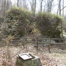
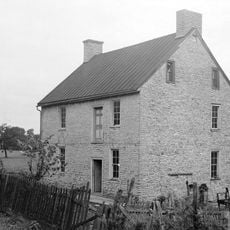
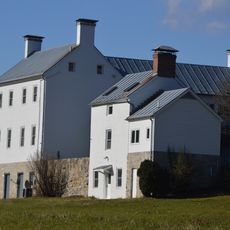
The site preserves physical traces of different periods through the Overall House ruins, a historic cemetery, and a nineteenth-century bridge foundation. These remnants show how the location mattered to people living here across generations.

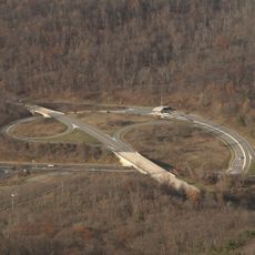
The site sits along U.S. Route 340 and is mostly private property, so visitors should observe the terrain from designated public viewing areas. These accessible spots offer good vantage points for seeing the preserved fortifications and landscape features.

The valley narrows at this location into a natural bottleneck that shaped military movements across multiple seasons. This geographic constraint meant armies repeatedly contested the same ground over several months of campaigning.

The community of curious travelers

AroundUs brings together thousands of curated places, local tips, and hidden gems, enriched daily by 60,000 contributors worldwide.

Start exploring
Location
GPS coordinates
38.80611,-78.34250
Latest update
December 14, 2025 14:45
Around this place
Elizabeth Furnace
United States of America

Elizabeth Furnace

14 km
Thornton Gap
United States of America

Thornton Gap

16.3 km
Shenandoah River Raymond R. "Andy" Guest Jr. State Park
United States of America

Shenandoah River Raymond R. "Andy" Guest Jr. State Park

6.5 km
Seven Bends State Park
United States of America

Seven Bends State Park

13.9 km
Signal Knob
United States of America

Signal Knob

17.3 km
Marys Rock Tunnel
United States of America

Marys Rock Tunnel

17.2 km
Short Mountain
United States of America

Short Mountain

17.5 km
Pignut Mountain
United States of America

Pignut Mountain

11.9 km
Front Royal Historic District
United States of America

Front Royal Historic District

17.9 km
Neighbor Mountain
United States of America

Neighbor Mountain

12.4 km
Warren County Courthouse
United States of America

Warren County Courthouse

17.9 km
Daniel Munch House
United States of America

Daniel Munch House

7.4 km
Stover House
United States of America

Stover House

13.4 km
Shenandoah County Farm
United States of America

Shenandoah County Farm

16.8 km
Abraham Beydler House
United States of America

Abraham Beydler House

13.8 km
Shenandoah County Courthouse
United States of America

Shenandoah County Courthouse

16.5 km
Toms Brook School
United States of America

Toms Brook School

17.7 km
Sunnyside
United States of America

Sunnyside

17.2 km
Bauserman Farm
United States of America

Bauserman Farm

13.8 km
Lantz Hall
United States of America

Lantz Hall

16.5 km
Heiston-Strickler House
United States of America

Heiston-Strickler House

17.9 km
Page County Bridge No. 1990
United States of America

Page County Bridge No. 1990

578 m
Woodstock Historic District
United States of America

Woodstock Historic District

16.4 km
Elkwallow Wayside
United States of America

Elkwallow Wayside

8.1 km
Dickey Ridge Visitor Center
United States of America

Dickey Ridge Visitor Center

14 km
Knob Mountain
United States of America

Knob Mountain

8.6 km
Redwell-Isabella Furnace Historic District
United States of America

Redwell-Isabella Furnace Historic District

17.2 km
Gooney Run Overlook
United States of America

Gooney Run Overlook

12.4 km
Show the full map
Reviews
Share your experience

No review yet

Discussions
Start a discussion...

No discussion yet

« Milford Battlefield - Civil War battlefield in Overall, Virginia » is provided by Around Us (aroundus.com). Images and texts are derived from Wikimedia project under a Creative Commons license. You are allowed to copy, distribute, and modify copies of this page, under the conditions set by the license, as long as this note is clearly visible.

Discover hidden gems everywhere you go!

From secret cafés to breathtaking viewpoints, skip the crowded tourist spots and find places that match your style. Our app makes it easy with voice search, smart filtering, route optimization, and insider tips from travelers worldwide. Download now for the complete mobile experience.

Around Us App Screenshot

A unique approach to discovering new places

Le Figaro

All the places worth exploring

France Info

A tailor-made excursion in just a few clicks

20 Minutes

Around Us
Travel Guide & Maps
Download

Send to your phone

QR Code
1

Open the camera app on your mobile.

2

Point at the QR code with your camera. A notification will appear.

3

Tap the notification to open the link.