Enable Location

We need your location to show you interesting places around you

Discover nearby places

Find interesting locations and hidden gems around you

Precise directions

Get accurate directions and distances to places

Your location is never shared with other users. It's only used when you tap the location button.

Log in to your account

Start exploring — it's free

Trusted by 63,045 travelers worldwide

Continue with Google
Continue with Apple
or

We will send you a code to connect

By continuing, you accept our Terms and Conditions and our Privacy Policy

Check your inbox

We've sent a pincode in your inbox. Please enter the code below.

Minnie Island State Park
Discussion Reviews Photo
1.5k Popularity

Minnie Island State Park, island in the United States of America

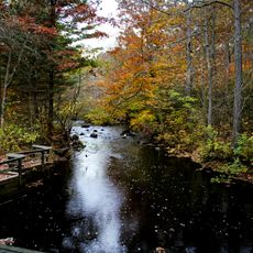
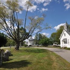
Minnie Island State Park is a tiny island in the middle of Gardner Lake covering less than one acre and accessible only by boat. The ground has simple walking paths and some open spaces to sit, but there are no large buildings or extensive facilities on the land.

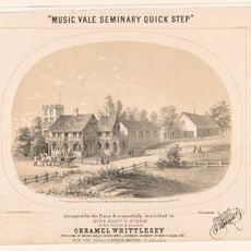
The island entered the state system in 1925 and was named after the niece of Orramel Whittelsey, who owned it during the 1800s. Over time the property changed hands several times before becoming public land.

The island takes its name from a girl who was the niece of Orramel Whittelsey, a former owner in the 1800s. Locals and visitors use the spot today much as people did in the past, gathering on the water to escape daily routines and enjoy quiet moments together.

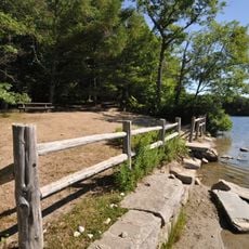
Visitors reach the island by boat from the Gardner Lake State Park launch. Bring everything you need for your stay since there are no shops, restrooms, or services on the island itself.

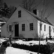
During colder months the island can be reached on foot across frozen water, creating a rare winter experience. This seasonal shift in how the place is accessed shows how the park transforms throughout the year.

The community of curious travelers

AroundUs brings together thousands of curated places, local tips, and hidden gems, enriched daily by 60,000 contributors worldwide.

Start exploring
Location
Inception
1925
Elevation above the sea
117 m
GPS coordinates
41.50583,-72.22194
Latest update
February 9, 2026 08:19
Around this place
Mohegan Sun
United States of America

Mohegan Sun

11 km
Devil's Hopyard State Park
United States of America

Devil's Hopyard State Park

10.8 km
The Earth Tower
United States of America

The Earth Tower

11 km
Nehantic State Forest
United States of America

Nehantic State Forest

10.2 km
The Dinosaur Place at Nature's Art Village
United States of America

The Dinosaur Place at Nature's Art Village

8.2 km
Bean Hill Historic District
United States of America

Bean Hill Historic District

10.9 km
Joseph Carpenter Silversmith Shop
United States of America

Joseph Carpenter Silversmith Shop

11.6 km
Bozrah Congregational Church and Parsonage
United States of America

Bozrah Congregational Church and Parsonage

7.4 km
Dr. Philip Turner House
United States of America

Dr. Philip Turner House

11.3 km
Raymond-Bradford Homestead
United States of America

Raymond-Bradford Homestead

5.6 km
Yantic Falls Historic District
United States of America

Yantic Falls Historic District

11.5 km
Historic Bridges of Devil's Hopyard State Park
United States of America

Historic Bridges of Devil's Hopyard State Park

10.6 km
Music Vale Seminary
United States of America

Music Vale Seminary

5 km
Samson Occom Bridge
United States of America

Samson Occom Bridge

11.6 km
Capt. Richard Charlton House
United States of America

Capt. Richard Charlton House

11.3 km
Salem Historic District
United States of America

Salem Historic District

4.8 km
Abel H. Fish House
United States of America

Abel H. Fish House

3.5 km
Simon Tiffany House
United States of America

Simon Tiffany House

9.8 km
New England Hebrew Farmers of the Emanuel Society Synagogue and Creamery Site
United States of America

New England Hebrew Farmers of the Emanuel Society Synagogue and Creamery Site

8.7 km
Norwich Bowling and Entertainment Center
United States of America

Norwich Bowling and Entertainment Center

10.9 km
Bridge No. 1603
United States of America

Bridge No. 1603

10.6 km
Discovery Depot at Nature's Art Village
United States of America

Discovery Depot at Nature's Art Village

8.3 km
Bridge No. 1605
United States of America

Bridge No. 1605

10.6 km
Bridge No. 1604
United States of America

Bridge No. 1604

10.6 km
Chapman Falls
United States of America

Chapman Falls

10.3 km
Yantic Falls Bridge
United States of America

Yantic Falls Bridge

11.4 km
Sunnyside Street Bridge
United States of America

Sunnyside Street Bridge

10.2 km
Yantic Falls Footbridge
United States of America

Yantic Falls Footbridge

11.4 km
Show the full map
Reviews
Share your experience

No review yet

Discussions
Start a discussion...

No discussion yet

« Minnie Island State Park - island in the United States of America » is provided by Around Us (aroundus.com). Images and texts are derived from Wikimedia project under a Creative Commons license. You are allowed to copy, distribute, and modify copies of this page, under the conditions set by the license, as long as this note is clearly visible.

Discover hidden gems everywhere you go!

From secret cafés to breathtaking viewpoints, skip the crowded tourist spots and find places that match your style. Our app makes it easy with voice search, smart filtering, route optimization, and insider tips from travelers worldwide. Download now for the complete mobile experience.

Around Us App Screenshot

A unique approach to discovering new places

Le Figaro

All the places worth exploring

France Info

A tailor-made excursion in just a few clicks

20 Minutes

Around Us
Travel Guide & Maps
Download

Send to your phone

QR Code
1

Open the camera app on your mobile.

2

Point at the QR code with your camera. A notification will appear.

3

Tap the notification to open the link.