Natchaug State Forest

Log in to your account

AroundUs is a community-driven map of interesting places, built by curious explorers like you. It grows with every review, story, and photo you share.
Connect to save your favorite spots, contribute locations, and create personalized routes.
Continue with Google
Continue with Apple
Continue with X
Continue with Facebook
Continue with email
By continuing, you accept our Terms and Conditions and our Privacy Policy
Create an account
Add to collection
Map
Suggest a change
Share

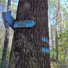
Natchaug State Forest, State forest in Ashford, Connecticut, US

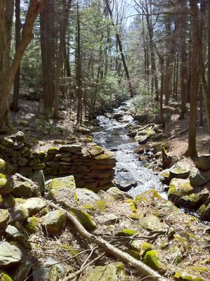
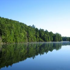
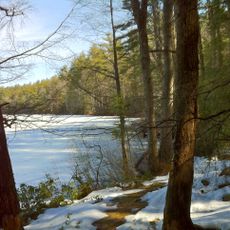
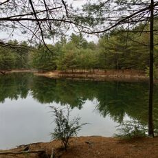
Natchaug State Forest is a large wooded area in Connecticut spanning over 13,000 acres with an extensive network of trails throughout. The Natchaug River forms the western boundary of the property and creates a natural corridor through the landscape.

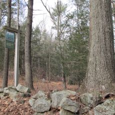
The forest was established in 1917 and has been managed by the Connecticut Department of Energy and Environmental Protection since its creation. This long-term stewardship has preserved the land's natural character throughout the decades.

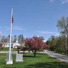
A small state park within the forest marks the birthplace of Civil War general Nathaniel Lyon, linking visitors to an important chapter of American military history. This memorial allows you to connect with the region's role in the nation's past.

The forest offers year-round activities including hiking, horseback riding, mountain biking, cross-country skiing, and fishing. The best time to visit depends on your interests, with spring and fall ideal for hiking and winter suitable for skiing.

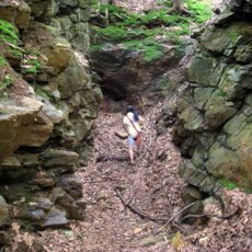
The forest holds numerous stone structures scattered throughout the property, remnants from earlier times. At a special location, the Bigelow River and Still River converge to form the Natchaug River, creating a distinctive geographic feature.

Location: Connecticut

Elevation above the sea: 181 m

GPS coordinates: 41.99900,-72.13200

Latest update: December 14, 2025 09:45

Photos
Around this place
Tantiusques
United States of America

Tantiusques

6.5 km
Bigelow Hollow State Park
United States of America

Bigelow Hollow State Park

635 m
Quinebaug Woods
United States of America

Quinebaug Woods

8.1 km
Nipmuck State Forest
United States of America

Nipmuck State Forest

0 m
George B. and Ruth D. Wells House
United States of America

George B. and Ruth D. Wells House

9.7 km
Ammidown-Harding Farmhouse
United States of America

Ammidown-Harding Farmhouse

10.5 km
Stephen Richard House
United States of America

Stephen Richard House

11 km
Union Green Historic District
United States of America

Union Green Historic District

2.5 km
Leadmine Wildlife Management Area
United States of America

Leadmine Wildlife Management Area

7.8 km
Judson–Litchfield House
United States of America

Judson–Litchfield House

10.9 km
Albert H. Wheeler House
United States of America

Albert H. Wheeler House

11.1 km
Sylvester Dresser House
United States of America

Sylvester Dresser House

11.4 km
H. Morse House
United States of America

H. Morse House

11.1 km
William Hodgson Two-Family House
United States of America

William Hodgson Two-Family House

11.4 km
Eugene Tapin House
United States of America

Eugene Tapin House

10.1 km
Glover Street Historic District
United States of America

Glover Street Historic District

11 km
Dennison School House
United States of America

Dennison School House

9 km
Henry E. Durfee Farmhouse
United States of America

Henry E. Durfee Farmhouse

10.3 km
Lorenzo R. Stone House
United States of America

Lorenzo R. Stone House

11.1 km
Upper Chapin Street Historic District
United States of America

Upper Chapin Street Historic District

11.3 km
Simon Plimpton Farmhouse
United States of America

Simon Plimpton Farmhouse

10.6 km
Bacon–Morse Historic District
United States of America

Bacon–Morse Historic District

10.6 km
High-School Streets Historic District
United States of America

High-School Streets Historic District

11.3 km
Clarke-Glover Farmhouse
United States of America

Clarke-Glover Farmhouse

11.2 km
Smith-Lyon Farmhouse
United States of America

Smith-Lyon Farmhouse

11.4 km
Natchaug Trail
United States of America

Natchaug Trail

0 m
Napoleon LaRochelle Two-Family House
United States of America

Napoleon LaRochelle Two-Family House

11.4 km
John M. Wells House
United States of America

John M. Wells House

9.6 km
Show the full map
Reviews

Visited this place? Tap the stars to rate it and share your experience / photos with the community! Try now! You can cancel it anytime.

« Natchaug State Forest - State forest in Ashford, Connecticut, US » is provided by Around Us (aroundus.com). Images and texts are derived from Wikimedia project under a Creative Commons license. You are allowed to copy, distribute, and modify copies of this page, under the conditions set by the license, as long as this note is clearly visible.

Discover hidden gems everywhere you go!

From secret cafés to breathtaking viewpoints, skip the crowded tourist spots and find places that match your style. Our app makes it easy with voice search, smart filtering, route optimization, and insider tips from travelers worldwide. Download now for the complete mobile experience.

Around Us App Screenshot

A unique approach to discovering new places

Le Figaro

All the places worth exploring

France Info

A tailor-made excursion in just a few clicks

20 Minutes