Enable Location

We need your location to show you interesting places around you

Discover nearby places

Find interesting locations and hidden gems around you

Precise directions

Get accurate directions and distances to places

Your location is never shared with other users. It's only used when you tap the location button.

Nipmuck State Forest

Log in to your account

Start exploring — it's free

Trusted by 62,492 travelers worldwide

Continue with Google
Continue with Apple
or

We will send you a code to connect

By continuing, you accept our Terms and Conditions and our Privacy Policy

Check your inbox

We've sent a pincode in your inbox. Please enter the code below.

Nipmuck State Forest

Nipmuck State Forest, State forest in Union, Connecticut, US.

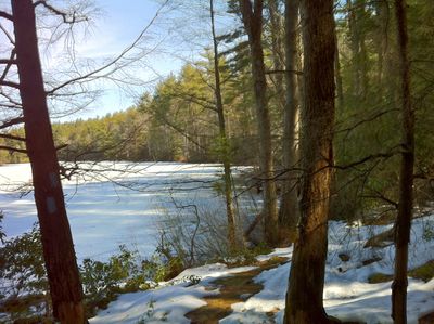
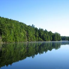
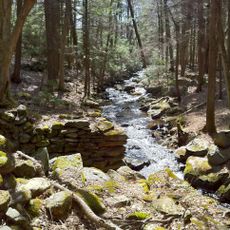
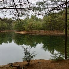
Nipmuck State Forest is a 9000-acre wooded area in Connecticut with varied terrain, mountain laurel groves, streams, and ponds connected by a network of trails. The landscape changes as you move through different sections of the forest.

The forest was established in 1905 and is managed by the Connecticut Department of Energy and Environmental Protection. It was created to protect the natural landscape for future generations.

The name comes from the Nipmuc people who lived here long before Europeans arrived. Their heritage remains woven into how locals and visitors understand this land.

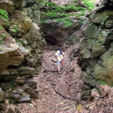
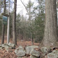
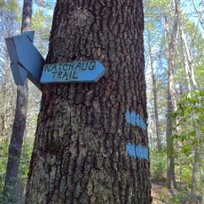
The forest offers more than 48 kilometers of marked trails with parking near the main access points. Sturdy footwear is important since the ground can be uneven and wet in places.

Snow Hill contains a special area where mountain laurel plants grow unusually tall, reaching up to 20 feet and creating a distinctive woodland setting found nowhere else nearby. This spot draws visitors interested in seeing these shrubs in their best form.

The community of curious travelers

AroundUs brings together thousands of curated places, local tips, and hidden gems, enriched daily by 60,000 contributors worldwide.

Start exploring
Elevation above the sea
288 m
GPS coordinates
41.99900,-72.13200
Latest update
December 13, 2025 12:20
Around this place
Tantiusques
United States of America

Tantiusques

6.5 km
Bigelow Hollow State Park
United States of America

Bigelow Hollow State Park

635 m
Quinebaug Woods
United States of America

Quinebaug Woods

8.1 km
Natchaug State Forest
United States of America

Natchaug State Forest

0 m
George B. and Ruth D. Wells House
United States of America

George B. and Ruth D. Wells House

9.7 km
Ammidown-Harding Farmhouse
United States of America

Ammidown-Harding Farmhouse

10.5 km
Stephen Richard House
United States of America

Stephen Richard House

11 km
Union Green Historic District
United States of America

Union Green Historic District

2.5 km
Leadmine Wildlife Management Area
United States of America

Leadmine Wildlife Management Area

7.8 km
Judson–Litchfield House
United States of America

Judson–Litchfield House

10.9 km
Albert H. Wheeler House
United States of America

Albert H. Wheeler House

11.1 km
Sylvester Dresser House
United States of America

Sylvester Dresser House

11.4 km
H. Morse House
United States of America

H. Morse House

11.1 km
William Hodgson Two-Family House
United States of America

William Hodgson Two-Family House

11.4 km
Eugene Tapin House
United States of America

Eugene Tapin House

10.1 km
Glover Street Historic District
United States of America

Glover Street Historic District

11 km
Dennison School House
United States of America

Dennison School House

9 km
Henry E. Durfee Farmhouse
United States of America

Henry E. Durfee Farmhouse

10.3 km
Lorenzo R. Stone House
United States of America

Lorenzo R. Stone House

11.1 km
Upper Chapin Street Historic District
United States of America

Upper Chapin Street Historic District

11.3 km
Simon Plimpton Farmhouse
United States of America

Simon Plimpton Farmhouse

10.6 km
Bacon–Morse Historic District
United States of America

Bacon–Morse Historic District

10.6 km
High-School Streets Historic District
United States of America

High-School Streets Historic District

11.3 km
Clarke-Glover Farmhouse
United States of America

Clarke-Glover Farmhouse

11.2 km
Smith-Lyon Farmhouse
United States of America

Smith-Lyon Farmhouse

11.4 km
Natchaug Trail
United States of America

Natchaug Trail

0 m
Napoleon LaRochelle Two-Family House
United States of America

Napoleon LaRochelle Two-Family House

11.4 km
John M. Wells House
United States of America

John M. Wells House

9.6 km
Show the full map
« Nipmuck State Forest - State forest in Union, Connecticut, US » is provided by Around Us (aroundus.com). Images and texts are derived from Wikimedia project under a Creative Commons license. You are allowed to copy, distribute, and modify copies of this page, under the conditions set by the license, as long as this note is clearly visible.

Discover hidden gems everywhere you go!

From secret cafés to breathtaking viewpoints, skip the crowded tourist spots and find places that match your style. Our app makes it easy with voice search, smart filtering, route optimization, and insider tips from travelers worldwide. Download now for the complete mobile experience.

Around Us App Screenshot

A unique approach to discovering new places

Le Figaro

All the places worth exploring

France Info

A tailor-made excursion in just a few clicks

20 Minutes

Around Us
Travel Guide & Maps
Download

Send to your phone

QR Code
1

Open the camera app on your mobile.

2

Point at the QR code with your camera. A notification will appear.

3

Tap the notification to open the link.