Enable Location

We need your location to show you interesting places around you

Discover nearby places

Find interesting locations and hidden gems around you

Precise directions

Get accurate directions and distances to places

Your location is never shared with other users. It's only used when you tap the location button.

National Weather Service Caribou, Maine

Log in to your account

Start exploring — it's free

Trusted by 62,834 travelers worldwide

Continue with Google
Continue with Apple
or

We will send you a code to connect

By continuing, you accept our Terms and Conditions and our Privacy Policy

Check your inbox

We've sent a pincode in your inbox. Please enter the code below.

National Weather Service Caribou, Maine

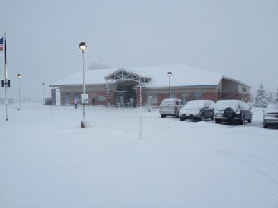
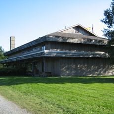
National Weather Service Caribou, Maine, Weather forecast office in Caribou, United States.

The National Weather Service office in Caribou is a meteorology station that monitors weather conditions and storms across northern Maine. The facility uses modern equipment to gather data and issue forecasts for the surrounding region.

The weather station in Caribou was established to document and understand the long, harsh winters of northern Maine. Over decades, it has collected important climate data that helps meteorologists analyze regional weather patterns.

Local communities in northern Maine have integrated weather forecasts from the Caribou office into their daily planning and agricultural activities.

Visitors and residents can access real-time weather alerts and forecasts through multiple online platforms available to the public. The services provide specific information for different activities such as agriculture and road conditions.

The station sits at a geographic location where weather patterns from Canada and the Atlantic Ocean can be observed and tracked. This makes it valuable for monitoring storm systems that approach from multiple directions into the region.

The community of curious travelers

AroundUs brings together thousands of curated places, local tips, and hidden gems, enriched daily by 60,000 contributors worldwide.

Start exploring
Location
GPS coordinates
46.86841,-68.01348
Latest update
December 14, 2025 11:20
Around this place
Double Eagle II
United States of America

Double Eagle II

26.9 km
Aroostook Valley Country Club
Canada

Aroostook Valley Country Club

18.7 km
Mars Hill
United States of America

Mars Hill

41.5 km
Fort Kent
United States of America

Fort Kent

61.2 km
United States of America

Loring Commerce Centre

11.7 km
Aroostook National Wildlife Refuge
United States of America

Aroostook National Wildlife Refuge

14.2 km
New Brunswick Botanical Garden
Canada

New Brunswick Botanical Garden

70.3 km
Loring Air Force Base Double Cantilever Hangar
United States of America

Loring Air Force Base Double Cantilever Hangar

12 km
Loring Air Force Base Arch Hangar
United States of America

Loring Air Force Base Arch Hangar

12.2 km
Fort Fairfield - Andover Border Crossing
United States of America

Fort Fairfield - Andover Border Crossing

20.6 km
Mark and Emily Turner Memorial Library
United States of America

Mark and Emily Turner Memorial Library

21 km
Florenceville Bridge
Canada

Florenceville Bridge

56.2 km
Acadian Landing Site
United States of America

Acadian Landing Site

57.4 km
Gustaf Adolph Lutheran Church
United States of America

Gustaf Adolph Lutheran Church

11.3 km
Musée Culturel du Mont-Carmel
United States of America

Musée Culturel du Mont-Carmel

46.3 km
Mont Farlagne
Canada

Mont Farlagne

65.9 km
Gray Memorial United Methodist Church and Parsonage
United States of America

Gray Memorial United Methodist Church and Parsonage

949 m
Acadian Village
United States of America

Acadian Village

37.5 km
Fort Fairfield Public Library
United States of America

Fort Fairfield Public Library

17.3 km
Philo Reed House
United States of America

Philo Reed House

18.5 km
Governor Brann School
United States of America

Governor Brann School

28.5 km
De la République Provincial Park
Canada

De la République Provincial Park

69.6 km
P'tit Sault Blockhouse
Canada

P'tit Sault Blockhouse

59.9 km
Cathédrale de l'Immaculée-Conception d'Edmundston
Canada

Cathédrale de l'Immaculée-Conception d'Edmundston

60.1 km
Potato World
Canada

Potato World

55.1 km
Mont Farlagne
Canada

Mont Farlagne

65.9 km
Isaie and Scholastique Martin House
United States of America

Isaie and Scholastique Martin House

59.5 km
Simon-Larouche Pavilion
Canada

Simon-Larouche Pavilion

60.4 km
Show the full map
« National Weather Service Caribou, Maine - Weather forecast office in Caribou, United States » is provided by Around Us (aroundus.com). Images and texts are derived from Wikimedia project under a Creative Commons license. You are allowed to copy, distribute, and modify copies of this page, under the conditions set by the license, as long as this note is clearly visible.

Discover hidden gems everywhere you go!

From secret cafés to breathtaking viewpoints, skip the crowded tourist spots and find places that match your style. Our app makes it easy with voice search, smart filtering, route optimization, and insider tips from travelers worldwide. Download now for the complete mobile experience.

Around Us App Screenshot

A unique approach to discovering new places

Le Figaro

All the places worth exploring

France Info

A tailor-made excursion in just a few clicks

20 Minutes

Around Us
Travel Guide & Maps
Download

Send to your phone

QR Code
1

Open the camera app on your mobile.

2

Point at the QR code with your camera. A notification will appear.

3

Tap the notification to open the link.