Old Blenheim Bridge

Log in to your account

AroundUs is a community-driven map of interesting places, built by curious explorers like you. It grows with every review, story, and photo you share.
Connect to save your favorite spots, contribute locations, and create personalized routes.
Continue with Google
Continue with Apple
Continue with X
Continue with Facebook
Continue with email
By continuing, you accept our Terms and Conditions and our Privacy Policy
Create an account
Add to collection
Map
Suggest a change
Share

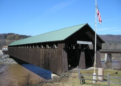
Old Blenheim Bridge, Covered bridge in North Blenheim, New York.

The Old Blenheim Bridge is a covered wooden structure crossing Schoharie Creek with two separate traffic lanes housed under a single roof. The double-barreled design allows vehicles to pass in both directions within distinct sections of the same enclosed framework.

The structure was built in 1855 by Nicholas Montgomery Powers and served the region for more than 150 years. A major flood destroyed the original in 2011, leading to its reconstruction in 2018 at a higher elevation using salvaged pieces from the previous crossing.

The bridge holds meaning for locals as a symbol of 19th-century craftsmanship and engineering. Visitors today come to experience how communities once moved across rivers and relied on wooden structures as vital connections.

The bridge is open to visitors who can walk across and examine the wooden framework up close. Plan to spend time exploring both the interior and exterior to fully appreciate the craftsmanship and how water flows beneath the structure.

The structure uses three separate trusses in its design: a main arch spanning the center and two smaller supports positioned on the sides. This unusual arrangement allowed it to handle traffic effectively while remaining more stable than many similar bridges from that era.

Location: New York

Official opening: 1855

GPS coordinates: 42.47253,-74.44127

Latest update: December 8, 2025 13:44

Photos
Around this place
Schoharie Reservoir
United States of America

Schoharie Reservoir

8.9 km
Pratt Rock
United States of America

Pratt Rock

18.1 km
Max V. Shaul State Park
United States of America

Max V. Shaul State Park

8.8 km
Lansing Manor House
United States of America

Lansing Manor House

3.1 km
Dr. Christopher S. Best House and Office
United States of America

Dr. Christopher S. Best House and Office

16.4 km
Main Street Historic District
United States of America

Main Street Historic District

22.7 km
Parker 13-Sided Barn
United States of America

Parker 13-Sided Barn

13.5 km
Union Chapel
United States of America

Union Chapel

20.9 km
Zadock Pratt House
United States of America

Zadock Pratt House

17.6 km
St. Mark's Evangelical Lutheran Church
United States of America

St. Mark's Evangelical Lutheran Church

16.5 km
Allan Teator Road Stone Arch Bridge
United States of America

Allan Teator Road Stone Arch Bridge

19.6 km
Brand Hollow Road Stone Arch Bridge
United States of America

Brand Hollow Road Stone Arch Bridge

18.3 km
Hardenburgh Falls
United States of America

Hardenburgh Falls

15 km
West Settlement Methodist Church
United States of America

West Settlement Methodist Church

16.6 km
Bute-Warner-Truax Farm
United States of America

Bute-Warner-Truax Farm

21 km
Livingstonville Community Church
United States of America

Livingstonville Community Church

14.3 km
Bellinger-Dutton House
United States of America

Bellinger-Dutton House

17 km
West Fulton Methodist Church
United States of America

West Fulton Methodist Church

10.3 km
Richmondville United Methodist Church
United States of America

Richmondville United Methodist Church

20.5 km
Breakabeen Historic District
United States of America

Breakabeen Historic District

7.4 km
North Settlement Methodist Church
United States of America

North Settlement Methodist Church

19.2 km
Elijah Strong House
United States of America

Elijah Strong House

20.5 km
North Blenheim Historic District
United States of America

North Blenheim Historic District

821 m
Mine Kill State Park
United States of America

Mine Kill State Park

4.4 km
New York Power Authority Blenheim-Gilboa Visitors Center
United States of America

New York Power Authority Blenheim-Gilboa Visitors Center

3.2 km
Lansing Manor House
United States of America

Lansing Manor House

3.2 km
Old Episcopal Manse
United States of America

Old Episcopal Manse

17.6 km
Morss Homestead/Federal City Homestead
United States of America

Morss Homestead/Federal City Homestead

18.5 km
Show the full map
Reviews

Visited this place? Tap the stars to rate it and share your experience / photos with the community! Try now! You can cancel it anytime.

« Old Blenheim Bridge - Covered bridge in North Blenheim, New York » is provided by Around Us (aroundus.com). Images and texts are derived from Wikimedia project under a Creative Commons license. You are allowed to copy, distribute, and modify copies of this page, under the conditions set by the license, as long as this note is clearly visible.

Discover hidden gems everywhere you go!

From secret cafés to breathtaking viewpoints, skip the crowded tourist spots and find places that match your style. Our app makes it easy with voice search, smart filtering, route optimization, and insider tips from travelers worldwide. Download now for the complete mobile experience.

Around Us App Screenshot

A unique approach to discovering new places

Le Figaro

All the places worth exploring

France Info

A tailor-made excursion in just a few clicks

20 Minutes