Enable Location

We need your location to show you interesting places around you

Discover nearby places

Find interesting locations and hidden gems around you

Precise directions

Get accurate directions and distances to places

Your location is never shared with other users. It's only used when you tap the location button.

Old Clark Bridge

Log in to your account

Start exploring — it's free

Trusted by 66,091 travelers worldwide

Continue with Google
Continue with Apple
or

We will send you a code to connect

By continuing, you accept our Terms and Conditions and our Privacy Policy

Check your inbox

We've sent a pincode in your inbox. Please enter the code below.

Old Clark Bridge
Discussion Reviews 1 Photos
3.8k Popularity

Old Clark Bridge, Truss bridge between West Alton and Alton, United States

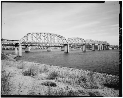
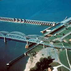
The Old Clark Bridge was a steel truss bridge that crossed the Mississippi River between West Alton, Missouri and Alton, Illinois. It carried two lanes of traffic as part of U.S. Route 67, connecting the two states at this section of the river.

The bridge was completed in 1928 and served as a main crossing between Missouri and Illinois for several decades. A new bridge opened nearby in 1994, after which the old span was demolished.

For decades, this crossing was the only direct link between Missouri and Illinois at this point along the river. Locals on both banks depended on it for everyday life, from work to family visits.

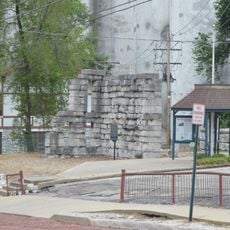
The bridge no longer stands, so there is nothing to walk across or enter. The site is best seen from the riverbanks near Alton, Illinois or West Alton, Missouri, where the new crossing now stands in its place.

Despite two major repairs in 1959 and 1975, the bridge was ultimately brought down by controlled explosives in 1994. Crowds gathered along the riverbanks to watch the demolition, treating it as a local event worth remembering.

The community of curious travelers

AroundUs brings together thousands of curated places, local tips, and hidden gems, enriched daily by 60,000 contributors worldwide.

Start exploring
Location
Inception
1928
Official opening
1928
GPS coordinates
38.88360,-90.18250
Latest update
March 3, 2026 14:02
Around this place
Piasa
United States of America

Piasa

2.1 km
Alton Museum of History and Art
United States of America

Alton Museum of History and Art

3.9 km
Clark Bridge
United States of America

Clark Bridge

349 m
Alton Military Prison
United States of America

Alton Military Prison

1.1 km
Melvin Price Locks and Dam
United States of America

Melvin Price Locks and Dam

3 km
Jones-Confluence Point State Park
United States of America

Jones-Confluence Point State Park

9.2 km
Fort Belle Fontaine
United States of America

Fort Belle Fontaine

6.9 km
Elijah P. Lovejoy Monument
United States of America

Elijah P. Lovejoy Monument

1.6 km
Lock and Dam No. 26
United States of America

Lock and Dam No. 26

283 m
Confluence Tower
United States of America

Confluence Tower

10.8 km
Fort Belle Fontaine County Park
United States of America

Fort Belle Fontaine County Park

7.3 km
Alton Bridge
United States of America

Alton Bridge

190 m
Lewis Bridge
United States of America

Lewis Bridge

6.3 km
Lyman Trumbull House
United States of America

Lyman Trumbull House

1.6 km
Bellefontaine Bridge
United States of America

Bellefontaine Bridge

6.5 km
Haskell Playhouse
United States of America

Haskell Playhouse

1.8 km
Christian Hill Historic District
United States of America

Christian Hill Historic District

1.5 km
Guertler House
United States of America

Guertler House

1.9 km
Benjamin Godfrey Memorial Chapel
United States of America

Benjamin Godfrey Memorial Chapel

7.5 km
Middletown Historic District (Alton, Illinois)
United States of America

Middletown Historic District (Alton, Illinois)

1.4 km
Upper Alton Historic District
United States of America

Upper Alton Historic District

4.2 km
Post House
United States of America

Post House

2.7 km
Salem Baptist Church
United States of America

Salem Baptist Church

10.6 km
Alton Chapter House
United States of America

Alton Chapter House

1.5 km
Yakel House and Union Brewery
United States of America

Yakel House and Union Brewery

1.9 km
Lewis & Clark Interpretive Center
United States of America

Lewis & Clark Interpretive Center

11.4 km
McPike Mansion
United States of America

McPike Mansion

2.5 km
Jamestown 14
United States of America

Jamestown 14

9.1 km
Show the full map
Reviews
Share your experience

No review yet

Discussions
Start a discussion...

No discussion yet

« Old Clark Bridge - Truss bridge between West Alton and Alton, United States » is provided by Around Us (aroundus.com). Images and texts are derived from Wikimedia project under a Creative Commons license. You are allowed to copy, distribute, and modify copies of this page, under the conditions set by the license, as long as this note is clearly visible.

Discover hidden gems everywhere you go!

From secret cafés to breathtaking viewpoints, skip the crowded tourist spots and find places that match your style. Our app makes it easy with voice search, smart filtering, route optimization, and insider tips from travelers worldwide. Download now for the complete mobile experience.

Around Us App Screenshot

A unique approach to discovering new places

Le Figaro

All the places worth exploring

France Info

A tailor-made excursion in just a few clicks

20 Minutes

Around Us
Travel Guide & Maps
Download

Send to your phone

QR Code
1

Open the camera app on your mobile.

2

Point at the QR code with your camera. A notification will appear.

3

Tap the notification to open the link.