Enable Location

We need your location to show you interesting places around you

Discover nearby places

Find interesting locations and hidden gems around you

Precise directions

Get accurate directions and distances to places

Your location is never shared with other users. It's only used when you tap the location button.

Opekiska Lock and Dam

Log in to your account

Start exploring — it's free

Trusted by 61,334 travelers worldwide

Continue with Google
Continue with Apple
or

We will send you a code to connect

By continuing, you accept our Terms and Conditions and our Privacy Policy

Check your inbox

We've sent a pincode in your inbox. Please enter the code below.

Opekiska Lock and Dam

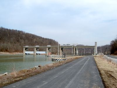
Opekiska Lock and Dam, Navigation lock and dam in Monongalia County, United States

Description

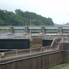
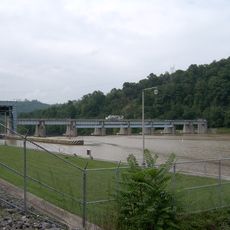
Opekiska Lock and Dam is a navigation structure spanning the Monongahela River that maintains adequate water depth for commercial and recreational vessels traveling between Fairmont and Pittsburgh. The facility features a single-chamber lock design that allows boats and barges to navigate elevation changes in the river.

History

The lock and dam were constructed between 1961 and 1964, replacing two earlier timber structures that dated to 1903. This modernization effort was part of a larger initiative to improve navigation capabilities along the Monongahela River system during the mid-20th century.

Culture

The lock and dam system represents the engineering achievements of the mid-20th century, demonstrating the importance of water management in American infrastructure development.

Practical

The Army Corps of Engineers operates the facility according to seasonal guidelines for commercial and recreational traffic. Conditions can change based on weather and water levels, so checking current operational status beforehand helps with planning.

Did you know?

The reservoir created behind this structure extends upstream for several miles and affects water levels in tributary streams beyond what many visitors might expect. The influence of this engineering project spreads through the larger river system in ways that shape the hydrology across multiple waterways.

GPS coordinates
39.56330,-80.04970
Latest update
December 14, 2025 09:47

AroundUs brings together thousands of curated places, local tips, and hidden gems, enriched daily by 60,000 contributors worldwide. Discover all places nearby (Monongalia County).

Around this place
Prickett's Fort State Park
United States of America

Prickett's Fort State Park

6.8 km
Earl L. Core Arboretum
United States of America

Earl L. Core Arboretum

11.1 km
United States of America

Old Stone House

10.9 km
Downtown Morgantown Historic District
United States of America

Downtown Morgantown Historic District

10.8 km
Monongalia County Courthouse
United States of America

Monongalia County Courthouse

10.8 km
Warner Theatre
United States of America

Warner Theatre

10.8 km
Morgantown Lock and Dam
United States of America

Morgantown Lock and Dam

9.4 km
Alexander Wade House
United States of America

Alexander Wade House

10.4 km
Dents Run Covered Bridge
United States of America

Dents Run Covered Bridge

6.8 km
Monongalia Arts Center
United States of America

Monongalia Arts Center

10.7 km
South Park Historic District
United States of America

South Park Historic District

10.6 km
Kern's Fort
United States of America

Kern's Fort

11 km
Waitman T. Willey House
United States of America

Waitman T. Willey House

10.4 km
Greenmont Historic District
United States of America

Greenmont Historic District

11 km
Hackney House
United States of America

Hackney House

11 km
Dering Building
United States of America

Dering Building

10.9 km
Harmony Grove Meeting House
United States of America

Harmony Grove Meeting House

6.8 km
George Pinkney Morgan House
United States of America

George Pinkney Morgan House

5.1 km
Chancery Hill Historic District
United States of America

Chancery Hill Historic District

10 km
Brown Building
United States of America

Brown Building

10.9 km
Old Watson Homestead House
United States of America

Old Watson Homestead House

3.8 km
Women's Christian Temperance Union Community Building
United States of America

Women's Christian Temperance Union Community Building

11 km
Jacob Prickett, Jr. Log House
United States of America

Jacob Prickett, Jr. Log House

6.6 km
Ford House
United States of America

Ford House

9.9 km
Judge Frank Cox House
United States of America

Judge Frank Cox House

10.5 km
Metropolitan Theatre
United States of America

Metropolitan Theatre

11 km
Kincaid and Arnett Feed and Flour Building
United States of America

Kincaid and Arnett Feed and Flour Building

10.1 km
Hildebrand Lock and Dam
United States of America

Hildebrand Lock and Dam

4 km
Show the full map
« Opekiska Lock and Dam - Navigation lock and dam in Monongalia County, United States » is provided by Around Us (aroundus.com). Images and texts are derived from Wikimedia project under a Creative Commons license. You are allowed to copy, distribute, and modify copies of this page, under the conditions set by the license, as long as this note is clearly visible.

Discover hidden gems everywhere you go!

From secret cafés to breathtaking viewpoints, skip the crowded tourist spots and find places that match your style. Our app makes it easy with voice search, smart filtering, route optimization, and insider tips from travelers worldwide. Download now for the complete mobile experience.

Around Us App Screenshot

A unique approach to discovering new places

Le Figaro

All the places worth exploring

France Info

A tailor-made excursion in just a few clicks

20 Minutes

Around Us
Travel Guide & Maps
Download

Send to your phone

QR Code
1

Open the camera app on your mobile.

2

Point at the QR code with your camera. A notification will appear.

3

Tap the notification to open the link.