Enable Location

We need your location to show you interesting places around you

Discover nearby places

Find interesting locations and hidden gems around you

Precise directions

Get accurate directions and distances to places

Your location is never shared with other users. It's only used when you tap the location button.

Dents Run Covered Bridge

Log in to your account

Start exploring — it's free

Trusted by 62,283 travelers worldwide

Continue with Google
Continue with Apple
or

We will send you a code to connect

By continuing, you accept our Terms and Conditions and our Privacy Policy

Check your inbox

We've sent a pincode in your inbox. Please enter the code below.

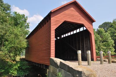
Dents Run Covered Bridge, Historic covered bridge in Monongalia County, United States.

Dents Run Covered Bridge is a wooden bridge with a roof that crosses the Dents Run creek in West Virginia, built using a traditional Kingpost design. The structure connects two roads and displays typical features of this historical building method from the late 1800s.

This bridge was built in 1889 with stone supports and a wooden framework designed by local craftsmen. It remains one of the few structures of its time that has survived to this day in the county.

The bridge shows how wooden structures were built in the 1800s and what craftsmanship techniques were used in the area. Visitors can see today how people created river crossings and which building methods proved durable.

The bridge sits at the intersection of two country roads and is easy to reach. Visitors should wear good shoes since the area is rural and access is on foot.

This is the last covered structure of its kind in the entire Monongalia County. Many other similar bridges were torn down or destroyed over time.

The community of curious travelers

AroundUs brings together thousands of curated places, local tips, and hidden gems, enriched daily by 60,000 contributors worldwide.

Start exploring
Inception
1889
GPS coordinates
39.62390,-80.04000
Latest update
December 14, 2025 14:43
Around this place
United States of America

Mountaineer Field

7.4 km
Woodburn Circle
United States of America

Woodburn Circle

7 km
Earl L. Core Arboretum
United States of America

Earl L. Core Arboretum

5.9 km
United States of America

Old Stone House

7.1 km
Opekiska Lock and Dam
United States of America

Opekiska Lock and Dam

6.8 km
Downtown Morgantown Historic District
United States of America

Downtown Morgantown Historic District

7.1 km
Monongalia County Courthouse
United States of America

Monongalia County Courthouse

7.1 km
Stewart Hall
United States of America

Stewart Hall

7.4 km
Warner Theatre
United States of America

Warner Theatre

7.1 km
Morgantown Lock and Dam
United States of America

Morgantown Lock and Dam

6.2 km
Elizabeth Moore Hall
United States of America

Elizabeth Moore Hall

7.3 km
Walters House
United States of America

Walters House

7.5 km
Alexander Wade House
United States of America

Alexander Wade House

7 km
Monongalia Arts Center
United States of America

Monongalia Arts Center

7 km
Star City Bridge
United States of America

Star City Bridge

5.6 km
Purinton House
United States of America

Purinton House

7.3 km
Waitman T. Willey House
United States of America

Waitman T. Willey House

6.9 km
Dering Building
United States of America

Dering Building

7.2 km
Harmony Grove Meeting House
United States of America

Harmony Grove Meeting House

4.8 km
Chancery Hill Historic District
United States of America

Chancery Hill Historic District

6.7 km
Brown Building
United States of America

Brown Building

7.2 km
Women's Christian Temperance Union Community Building
United States of America

Women's Christian Temperance Union Community Building

7.2 km
D.I.B. Anderson Farm
United States of America

D.I.B. Anderson Farm

6.9 km
Ford House
United States of America

Ford House

6.7 km
Judge Frank Cox House
United States of America

Judge Frank Cox House

7.2 km
Metropolitan Theatre
United States of America

Metropolitan Theatre

7.3 km
Hildebrand Lock and Dam
United States of America

Hildebrand Lock and Dam

5.2 km
Kincaid and Arnett Feed and Flour Building
United States of America

Kincaid and Arnett Feed and Flour Building

6.5 km
Show the full map
« Dents Run Covered Bridge - Historic covered bridge in Monongalia County, United States » is provided by Around Us (aroundus.com). Images and texts are derived from Wikimedia project under a Creative Commons license. You are allowed to copy, distribute, and modify copies of this page, under the conditions set by the license, as long as this note is clearly visible.

Discover hidden gems everywhere you go!

From secret cafés to breathtaking viewpoints, skip the crowded tourist spots and find places that match your style. Our app makes it easy with voice search, smart filtering, route optimization, and insider tips from travelers worldwide. Download now for the complete mobile experience.

Around Us App Screenshot

A unique approach to discovering new places

Le Figaro

All the places worth exploring

France Info

A tailor-made excursion in just a few clicks

20 Minutes

Around Us
Travel Guide & Maps
Download

Send to your phone

QR Code
1

Open the camera app on your mobile.

2

Point at the QR code with your camera. A notification will appear.

3

Tap the notification to open the link.