Enable Location

We need your location to show you interesting places around you

Discover nearby places

Find interesting locations and hidden gems around you

Precise directions

Get accurate directions and distances to places

Your location is never shared with other users. It's only used when you tap the location button.

Pooles Island Light

Log in to your account

Start exploring — it's free

Trusted by 65,173 travelers worldwide

Continue with Google
Continue with Apple
or

We will send you a code to connect

By continuing, you accept our Terms and Conditions and our Privacy Policy

Check your inbox

We've sent a pincode in your inbox. Please enter the code below.

Discussion Reviews 1 Photos
4.5k Popularity

Pooles Island Light, Lighthouse in Harford County, Maryland, US

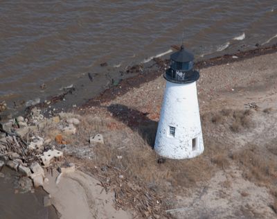
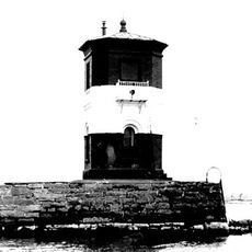
Pooles Island Light is a granite lighthouse tower in the Chesapeake Bay, Harford County, Maryland, rising about 38 feet (11.5 m) tall. It stands on a small, isolated island and is fitted with a fourth-order Fresnel lens, making it visible from the water even though the island itself is closed to the public.

The lighthouse was completed in 1825 after Congress approved its construction the previous year, and it ranks among the earliest built on the Chesapeake Bay. After decades out of service, it was eventually reactivated and is now listed on the National Register of Historic Places.

The tower is one of the oldest surviving lighthouses on the Chesapeake Bay and is recognized as a landmark by boaters passing through the area. Its name comes from Pooles Island, the small landmass on which it stands, named after an early colonial settler.

The island is closed to visitors because of unexploded ordnance left from its past use as a military training ground, so the lighthouse can only be seen from the water. A boat tour of the Chesapeake Bay offers a good vantage point for viewing the tower from a safe distance.

After sitting dark for nearly 72 years, the tower was briefly relit as part of a military anniversary celebration, making it one of the rare lighthouses to be temporarily reactivated for a ceremonial reason. The event drew attention to the structure at a time when most people had long forgotten it was still standing.

The community of curious travelers

AroundUs brings together thousands of curated places, local tips, and hidden gems, enriched daily by 60,000 contributors worldwide.

Start exploring
Location
Inception
1825
Height
11.5 m
GPS coordinates
39.29055,-76.26644
Latest update
March 3, 2026 08:12
Around this place
Fort Howard
United States of America

Fort Howard

18.4 km
Hart-Miller Island State Park, Maryland
United States of America

Hart-Miller Island State Park, Maryland

10.5 km
Glenn L. Martin Maryland Aviation Museum
United States of America

Glenn L. Martin Maryland Aviation Museum

14 km
Craighill Channel Lower Range Front Light
United States of America

Craighill Channel Lower Range Front Light

15.8 km
Bengie's Drive-In Theatre
United States of America

Bengie's Drive-In Theatre

12.9 km
Todd Farmhouse
United States of America

Todd Farmhouse

17.1 km
Craighill Channel Lower Range Rear Light
United States of America

Craighill Channel Lower Range Rear Light

13 km
Chestertown Historic District
United States of America

Chestertown Historic District

19.1 km
Ballestone Mansion
United States of America

Ballestone Mansion

13.7 km
Gunpowder Meetinghouse
United States of America

Gunpowder Meetinghouse

13.1 km
Craighill Channel Upper Range Front Light
United States of America

Craighill Channel Upper Range Front Light

18.8 km
Craighill Channel Upper Range Rear Light
United States of America

Craighill Channel Upper Range Rear Light

18.8 km
Fairlee Manor Camp House
United States of America

Fairlee Manor Camp House

7.6 km
Airy Hill
United States of America

Airy Hill

18.5 km
Carvill Hall
United States of America

Carvill Hall

6.6 km
Hinchingham
United States of America

Hinchingham

10.8 km
Radcliffe Mill
United States of America

Radcliffe Mill

17.9 km
Gobbler Hill
United States of America

Gobbler Hill

7.6 km
Brampton
United States of America

Brampton

17.1 km
Nelson-Reardon-Kennard House
United States of America

Nelson-Reardon-Kennard House

19.4 km
Hopeful Unity
United States of America

Hopeful Unity

16.5 km
Reward-Tilden's Farm
United States of America

Reward-Tilden's Farm

18.7 km
North Point State Park
United States of America

North Point State Park

16.6 km
Marshy Point Nature Center
United States of America

Marshy Point Nature Center

11.8 km
Lauretum
United States of America

Lauretum

17.5 km
Gunpowder River Bridge
United States of America

Gunpowder River Bridge

12.8 km
Bush River Bridge
United States of America

Bush River Bridge

16.4 km
Middle, East and West Halls
United States of America

Middle, East and West Halls

18.9 km
Show the full map
Reviews
Share your experience

No review yet

Discussions
Start a discussion...

No discussion yet

« Pooles Island Light - Lighthouse in Harford County, Maryland, US » is provided by Around Us (aroundus.com). Images and texts are derived from Wikimedia project under a Creative Commons license. You are allowed to copy, distribute, and modify copies of this page, under the conditions set by the license, as long as this note is clearly visible.

Discover hidden gems everywhere you go!

From secret cafés to breathtaking viewpoints, skip the crowded tourist spots and find places that match your style. Our app makes it easy with voice search, smart filtering, route optimization, and insider tips from travelers worldwide. Download now for the complete mobile experience.

Around Us App Screenshot

A unique approach to discovering new places

Le Figaro

All the places worth exploring

France Info

A tailor-made excursion in just a few clicks

20 Minutes

Around Us
Travel Guide & Maps
Download

Send to your phone

QR Code
1

Open the camera app on your mobile.

2

Point at the QR code with your camera. A notification will appear.

3

Tap the notification to open the link.