Craighill Channel Lower Range Rear Light

Log in to your account

AroundUs is a community-driven map of interesting places, built by curious explorers like you. It grows with every review, story, and photo you share.
Connect to save your favorite spots, contribute locations, and create personalized routes.
Continue with Google
Continue with Apple
Continue with X
Continue with Facebook
Continue with email
By continuing, you accept our Terms and Conditions and our Privacy Policy
Create an account
Add to collection
Map
Suggest a change
Share

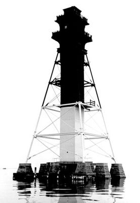
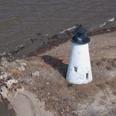
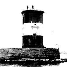
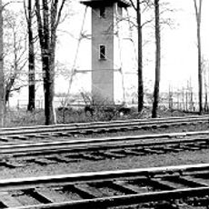
Craighill Channel Lower Range Rear Light, Maritime navigation structure in Baltimore County, United States.

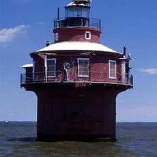
Craighill Channel Lower Range Rear Light is a navigation structure in Baltimore County standing 105 feet tall with an iron skeleton framework. The central wooden shaft is reinforced with iron plating, and the entire tower rests on a carefully engineered foundation system.

The lighthouse was built in 1873 and required nine stone piers to support its weight. Major repairs came in 1884 when wooden braces were replaced with stronger metal reinforcements.

The lighthouse takes its name from William Price Craighill, an engineer who shaped shipping routes in the bay. It serves as a visual marker for captains entering Baltimore Harbor and finding their way through busy water passages.

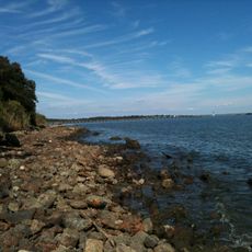
The lighthouse sits near Ramona Beach and Edgemere and is best viewed from the water or from a distance along the coast. As a working aid for maritime navigation, it remains a notable landmark when traveling through or around Baltimore Harbor.

This is the tallest lighthouse in Maryland, and its caisson design proved especially able to withstand damage from ice floes in Chesapeake Bay. The iron reinforced structure could better resist impacts from drifting ice than traditional construction methods.

Location: Baltimore County

GPS coordinates: 39.22903,-76.39440

Latest update: December 14, 2025 11:20

Photos
Around this place
Fort McHenry
United States of America

Fort McHenry

16.4 km
NS Savannah
United States of America

NS Savannah

14.3 km
Francis Scott Key Bridge
United States of America

Francis Scott Key Bridge

11.6 km
SS John W. Brown
United States of America

SS John W. Brown

15.7 km
Fort Carroll
United States of America

Fort Carroll

10.9 km
National Brewing Company
United States of America

National Brewing Company

15.8 km
United States Coast Guard Yard
United States of America

United States Coast Guard Yard

15.3 km
Fort Howard
United States of America

Fort Howard

5.4 km
Greater Grace World Outreach
United States of America

Greater Grace World Outreach

16 km
Fort Smallwood Park
United States of America

Fort Smallwood Park

10.1 km
Pooles Island Light
United States of America

Pooles Island Light

13 km
Hart-Miller Island State Park, Maryland
United States of America

Hart-Miller Island State Park, Maryland

2.9 km
Glenn L. Martin Maryland Aviation Museum
United States of America

Glenn L. Martin Maryland Aviation Museum

11.2 km
Craighill Channel Lower Range Front Light
United States of America

Craighill Channel Lower Range Front Light

4.5 km
Fort Carroll Light
United States of America

Fort Carroll Light

10.9 km
Todd Farmhouse
United States of America

Todd Farmhouse

4.2 km
Hancock's Resolution
United States of America

Hancock's Resolution

11.4 km
Ballestone Mansion
United States of America

Ballestone Mansion

3.3 km
Lazaretto Point Light
United States of America

Lazaretto Point Light

15.7 km
Bodkin Island Light
United States of America

Bodkin Island Light

10.9 km
Craighill Channel Upper Range Front Light
United States of America

Craighill Channel Upper Range Front Light

5.8 km
Craighill Channel Upper Range Rear Light
United States of America

Craighill Channel Upper Range Rear Light

6.1 km
Fairlee Manor Camp House
United States of America

Fairlee Manor Camp House

16.5 km
Hinchingham
United States of America

Hinchingham

13.1 km
Marley Neck Rosenwald School
United States of America

Marley Neck Rosenwald School

16.4 km
North Point State Park
United States of America

North Point State Park

3.6 km
Marshy Point Nature Center
United States of America

Marshy Point Nature Center

13.6 km
Wilson Point Mens' Club; Stansbury Beach Club
United States of America

Wilson Point Mens' Club; Stansbury Beach Club

10 km
Show the full map
Reviews

Visited this place? Tap the stars to rate it and share your experience / photos with the community! Try now! You can cancel it anytime.

« Craighill Channel Lower Range Rear Light - Maritime navigation structure in Baltimore County, United States » is provided by Around Us (aroundus.com). Images and texts are derived from Wikimedia project under a Creative Commons license. You are allowed to copy, distribute, and modify copies of this page, under the conditions set by the license, as long as this note is clearly visible.

Discover hidden gems everywhere you go!

From secret cafés to breathtaking viewpoints, skip the crowded tourist spots and find places that match your style. Our app makes it easy with voice search, smart filtering, route optimization, and insider tips from travelers worldwide. Download now for the complete mobile experience.

Around Us App Screenshot

A unique approach to discovering new places

Le Figaro

All the places worth exploring

France Info

A tailor-made excursion in just a few clicks

20 Minutes