Enable Location

We need your location to show you interesting places around you

Discover nearby places

Find interesting locations and hidden gems around you

Precise directions

Get accurate directions and distances to places

Your location is never shared with other users. It's only used when you tap the location button.

Platte Mound M

Log in to your account

Start exploring — it's free

Trusted by 62,404 travelers worldwide

Continue with Google
Continue with Apple
or

We will send you a code to connect

By continuing, you accept our Terms and Conditions and our Privacy Policy

Check your inbox

We've sent a pincode in your inbox. Please enter the code below.

Platte Mound M

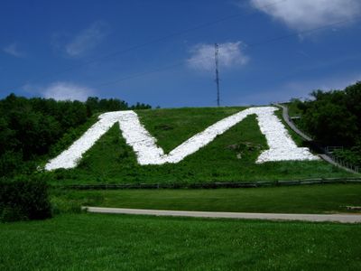
Platte Mound M, Hillside letter on Platte Mound near Platteville, Wisconsin.

Platte Mound M is a large stone letter positioned on a hillside near Platteville in Wisconsin. The formation spans across the slope and creates a bold visual mark that stands out prominently from many vantage points in the surrounding area.

The letter was conceived in 1937 by two university students who drew inspiration from a similar formation at a Colorado mine site. This vision resulted in a permanent stone monument that visibly connected the place to the region's mining past.

The letter represents the mining tradition rooted in the town's past and remains an emblem that students and locals maintain together. This landmark expresses community pride and connects people to the industrial heritage that shaped the area.

To view the letter up close, visitors need to climb stairs that lead to the top of the mound. The effort rewrites with a panoramic outlook over the university grounds and the surrounding landscape.

Before the permanent stone letter was built, the students first marked the design using snow in winter 1936 to visualize their idea. This temporary version disappeared quickly but led to the lasting construction that remains today.

The community of curious travelers

AroundUs brings together thousands of curated places, local tips, and hidden gems, enriched daily by 60,000 contributors worldwide.

Start exploring
Location
Inception
1937
GPS coordinates
42.76354,-90.40677
Latest update
December 8, 2025 19:42
Around this place
Potosi Brewery
United States of America

Potosi Brewery

27.8 km
Dickeyville Grotto
United States of America

Dickeyville Grotto

21.6 km
Pendarvis
United States of America

Pendarvis

22.1 km
First Capitol Historic Site
United States of America

First Capitol Historic Site

3.8 km
Patrick and Margaret Kinney House
United States of America

Patrick and Margaret Kinney House

27.4 km
Belmont Mound State Park
United States of America

Belmont Mound State Park

4.7 km
United States of America

Fort Union

29.1 km
Saint Augustine Church
United States of America

Saint Augustine Church

26.3 km
Grant County Courthouse
United States of America

Grant County Courthouse

26.5 km
Saint Patrick's Church
United States of America

Saint Patrick's Church

21.9 km
Benton Stone Water Tower
United States of America

Benton Stone Water Tower

21.6 km
Mitchell-Rountree House
United States of America

Mitchell-Rountree House

6.7 km
Hazel Green Town Hall
United States of America

Hazel Green Town Hall

25.7 km
First Congregational Church
United States of America

First Congregational Church

6.6 km
J. H. Rountree Mansion
United States of America

J. H. Rountree Mansion

6.8 km
Potosi Badger Huts Site
United States of America

Potosi Badger Huts Site

26.4 km
Beebe House
United States of America

Beebe House

6.6 km
Gratiot House
United States of America

Gratiot House

27.5 km
Jonathan H. Evans House
United States of America

Jonathan H. Evans House

6.7 km
Beach @ Black Hawk Lake Recreation Area
United States of America

Beach @ Black Hawk Lake Recreation Area

30.8 km
Water Street Commercial Historic District
United States of America

Water Street Commercial Historic District

25 km
Ullrich Hall
United States of America

Ullrich Hall

7.3 km
L. J. Arthur House
United States of America

L. J. Arthur House

26.6 km
Division Street Historic District
United States of America

Division Street Historic District

7 km
Main Street Historic District
United States of America

Main Street Historic District

25.4 km
Main Street Commercial Historic District
United States of America

Main Street Commercial Historic District

6.7 km
Spensley Farm
United States of America

Spensley Farm

20.5 km
The Mining and Rollo Jamison Museum
United States of America

The Mining and Rollo Jamison Museum

6.4 km
Show the full map
« Platte Mound M - Hillside letter on Platte Mound near Platteville, Wisconsin » is provided by Around Us (aroundus.com). Images and texts are derived from Wikimedia project under a Creative Commons license. You are allowed to copy, distribute, and modify copies of this page, under the conditions set by the license, as long as this note is clearly visible.

Discover hidden gems everywhere you go!

From secret cafés to breathtaking viewpoints, skip the crowded tourist spots and find places that match your style. Our app makes it easy with voice search, smart filtering, route optimization, and insider tips from travelers worldwide. Download now for the complete mobile experience.

Around Us App Screenshot

A unique approach to discovering new places

Le Figaro

All the places worth exploring

France Info

A tailor-made excursion in just a few clicks

20 Minutes

Around Us
Travel Guide & Maps
Download

Send to your phone

QR Code
1

Open the camera app on your mobile.

2

Point at the QR code with your camera. A notification will appear.

3

Tap the notification to open the link.